James Spann: Severe storms possible in Alabama Saturday
COOLER DAY: Yesterday at this time, temperatures were soaring into the mid to upper 80s across Alabama, but today the northern half of the state is considerably cooler, with readings mostly in the 60s. The light rain we had on radar this morning has moved into Georgia, and things are quiet at mid-afternoon. Tonight will be fair and cool, with a low between 48 and 52 degrees for most communities.
TOMORROW/FRIDAY: For now both days look pretty tranquil, with a mix of sun and clouds; we have removed the small risk of a shower tomorrow. The high tomorrow afternoon will be in the upper 60s, followed by mid 70s Friday.
To the west, severe storms are possible Friday over the eastern half of Texas and Oklahoma, into Arkansas and Louisiana as a potent weather system moves out of the Rockies.
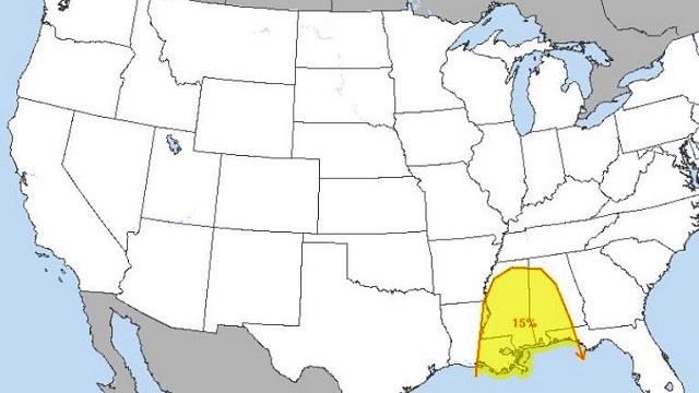
STORMY DAY SATURDAY: That same weather system will bring the risk of severe storms to Alabama Saturday. A broad surface low with good upper support will be over Missouri, and an unstable airmass will be in place, with surface-based CAPE values rising to more than 1,500 j/kg over the western half of our state. Forecast soundings show a favorable atmospheric setup for strong to severe storms, and the Storm Prediction Center has a decent part of the state in a severe weather risk.

TIMING: For now the main 12-hour window for severe storms will come from noon through midnight Saturday.
PLACEMENT: The highest severe weather risk will be over the western half of the state, generally from I-65 westward, where the best combination of instability, shear and lift will be present.
THREATS: Looks like all modes of severe weather will be possible, including large hail, damaging winds and a few tornados.
RAIN: Rain amounts will be around 1 inch, not enough for flooding issues.
Remember, this event is still four days away, and this could easily change, so keep up with the latest posts for potential revisions.
A few lingering showers are possible Sunday morning; there’s a decent chance Sunday afternoon will be dry. Highs over the weekend will be in the 70s.
NEXT WEEK: A moist, unstable airmass will hold in place through the week. There will be some risk of showers and storms Monday and Tuesday; Wednesday looks relatively quiet for now. A stronger system could impact Alabama late in the week.

STORM SPOTTER TRAINING: We will be on the road through early April offering free storm spotter classes. We need more trained spotters in Alabama. By attending, you can make the severe weather warning process better. No need to register; just come with a curious mind. And there is no age limit; kids who love weather will enjoy it. You will never look at a storm the same again. The next class will be Thursday evening at the Gardendale Civic Center at 6:30.
WEATHER BRAINS: You can listen to our weekly 90-minute netcast anytime on the web, or on iTunes. This is the show all about weather featuring many familiar voices, including meteorologists at ABC 33/40.
CONNECT: You can find me on all of the major social networks:
Facebook
Twitter
Google Plus
Instagram
Pinterest
Snapchat: spannwx
For more weather news and information, visit AlabamaWX.


