James Spann: Tomorrow brings potential for tornadoes, damaging winds to Alabama
WARM SPRING AFTERNOON: Temperatures are mostly in the 80- to 84-degree range across north and central Alabama this afternoon with a good supply of sunshine; no showers are on radar. The sky will stay mostly fair tonight, but strong to severe storms will fire up west of Alabama across much of Louisiana and Arkansas in coming hours.
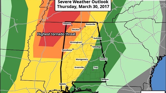
SEVERE WEATHER SETUP: The Storm Prediction Center maintains a “moderate” severe weather risk for the northwest corner of Alabama late tomorrow and tomorrow night, with an “enhanced” risk along and west of a line from Huntsville to Carbon Hill to Gordo. Places like Birmingham, Tuscaloosa, Anniston and Gadsden are in the standard “slight risk” area. There is a “marginal” risk for east and southeast Alabama.

The large-scale, synoptic pattern certainly favors severe weather, with a surface low near St. Louis supported by an upper trough with strong wind fields.
The big question involves the possibility of morning convection. If a mass of morning storms moves through Alabama, it could stabilize the atmosphere and mitigate the risk of severe storms later in the day and tomorrow night. However, the latest high-resolution North American Mesoscale run shows no morning storms, and a strong setup for severe weather over northwest Alabama by late afternoon.
THREATS: The highest risk of tornadoes will be in the “moderate” and “enhanced” risk areas of west and northwest Alabama. A strong, long-track tornado is possible in this zone. As you get into the “slight” risk area, the main issue will become strong straight-line winds and hail, although an isolated tornado is still possible.
TIMING: The risk begins around 5 tomorrow afternoon over far northwest and west Alabama, with storms moving eastward tomorrow night. The event should wind down by 1 a.m. Friday.
RAIN: Rain amounts of around 1 inch are likely; no flooding is expected.
CALL TO ACTION: Be sure you have a way of getting warnings; a NOAA Weather Radio is the baseline, and a good smartphone app is the other tier. Identify the safe place in your home and be sure everyone knows where it is. In that safe place, have helmets for everyone, along with hard-sole shoes and preferably a portable airhorn in case you need help.
FRIDAY AND THE WEEKEND: Friday and Saturday will feature ample sunshine; the high Friday will be in the 70s, and temperatures will peak at or just over 80 degrees on Saturday. Sunday will be partly sunny with a high again close to 80 degrees. A few showers and storms could creep into the state Sunday night ahead of the next storm system in the active wave train pattern.
NEXT WEEK: We will have another setup for strong to severe storms Monday across the state, and potentially another one later in the week. It’s way too early to be specific.

SPOTTER TRAINING IN JASPER POSTPONED: Because of the threat of severe storms (somewhat ironic), the spotter training planned for tomorrow evening in Jasper will be rescheduled; the next session is Tuesday at Shelton State Community College in Tuscaloosa. The big event is April 8 at the BJCC in Birmingham, when the basic and the advanced class will be offered; that will run from 9 a.m. until 2 p.m. It will be in North Meeting Rooms C-I. Attendees will go up the elevator to the second floor.
Click here to see the Beach Forecast Center page.
WEATHER BRAINS: You can listen to our weekly 90-minute netcast anytime on the web, or on iTunes. This is the show all about weather featuring many familiar voices, including meteorologists at ABC 33/40.
CONNECT: You can find me on all of the major social networks:
Facebook
Twitter
Google Plus
Instagram
Pinterest
Snapchat: spannwx
For more weather news and information, visit AlabamaWX.


