James Spann: Showers widely spaced over Alabama this afternoon
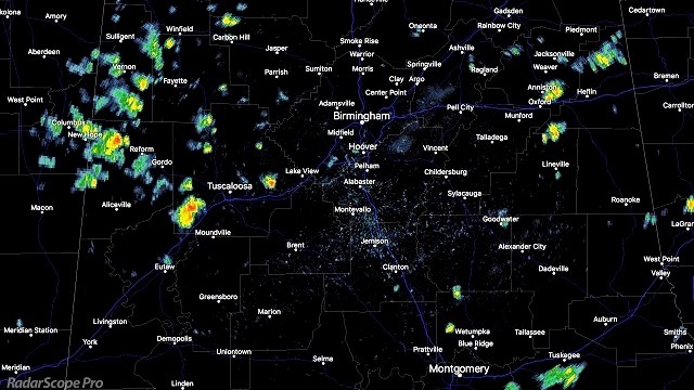
RADAR CHECK: As expected, we have a few random, widely spaced showers and storms across the southern two-thirds of Alabama this afternoon south of a surface front; the showers are drifting to the southwest.

Away from the showers, we have a mix of sun and clouds with temperatures in the upper 70s and lows 80s. Showers will end once the sun goes down.
TOMORROW THROUGH THE EASTER WEEKEND: The surface front over far North Alabama will dissipate, and with the upper ridge holding strong, the weather looks warm and mostly dry on these four days — partly to mostly sunny days and fair, pleasant nights. Highs will be in the 81- to 85-degree range, with early morning lows between 58 and 62. There will be a slow moisture increase over the weekend, but warm air aloft associated with the ridge means only a tiny risk of any one spot seeing a shower.
NEXT WEEK: A surface front will drift down toward the Alabama/Tennessee border, and we will mention the chance of scattered showers Monday and Tuesday, but rain amounts won’t be especially heavy. The rest of the week looks warm and dry as the benign pattern continues.

BARONS HOME OPENER: The first pitch is tonight at 7:05 p.m. at Regions Field in Birmingham, as the Barons host the Montgomery Biscuits. Just a small risk of a shower during the first few innings of the game; otherwise mostly fair and very pleasant, with temperatures falling through the 70s.
Click here to see the Beach Forecast Center page.
WEATHER BRAINS: You can listen to our weekly 90-minute netcast anytime on the web, or on iTunes. This is the show all about weather featuring many familiar voices, including meteorologists at ABC 33/40.
CONNECT: You can find me on all of the major social networks:
Facebook
Twitter
Google Plus
Instagram
Pinterest
Snapchat: spannwx
For more weather news and information, visit AlabamaWX.


