James Spann: Warm April days are here, will linger a while in Alabama
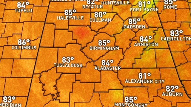
SUNNY, WARM APRIL AFTERNOON: Temperatures have reached the mid 80s across North/Central Alabama this afternoon — about 10 degrees above average, right at record levels. Birmingham’s record high today is 86, set in 1981; there’s a decent chance we tie or even break it before the day is over.

We will continue to flirt with record highs through the Easter weekend as an upper ridge holds across Alabama and the Deep South. We project partly to mostly sunny, warm days, and fair, pleasant nights through Sunday. Highs 81-85, lows 58-62.
Here are the record highs for Birmingham through the weekend:
- April 14 (Friday) — 89 (1981)
- April 15 (Saturday) — 88 (1936)
- April 16 (Sunday) — 89 (1977)
NEXT WEEK: A cold front will sag southward through Tennessee and will bring the chance of showers to the northern half of Alabama, but with the upper ridge rain amounts should be light.
That front will move back northward as a warm front Tuesday, and any showers over North Alabama will be few and far between. The rest of the week looks warm and mostly dry; seems like we will have some risk of rain the following weekend (April 22-23) as the ridge weakens.

DROUGHT MONITOR: Drought conditions continue to improve across Alabama, based on the new Drought Monitor released this morning. But keep in mind with the current dry pattern there is a chance conditions will begin to deteriorate next week.

Click here to see the Beach Forecast Center page.
WEATHER BRAINS: You can listen to our weekly 90-minute netcast anytime on the web, or on iTunes. This is the show all about weather featuring many familiar voices, including meteorologists at ABC 33/40.
CONNECT: You can find me on all of the major social networks:
Facebook
Twitter
Google Plus
Instagram
Pinterest
Snapchat: spannwx
For more weather news and information, visit AlabamaWX.


