James Spann: Big warm-up today for Alabama; storms Thursday
James Spann: After a cool start, Alabama temperatures will near 80 today from Alabama NewsCenter on Vimeo.
REFRESHING MORNING: Many communities were in the 40s early this morning. Here are some of the cooler spots at daybreak:
- Cullman — 46
- Cottondale — 46
- Haleyville — 46
- Russellville — 46
- Coker — 47
- Black Creek — 47
- Gadsden — 48
- Alexander City — 48
We have patches of dense fog, and a dense fog advisory is in effect for the Tennessee Valley of far North Alabama. The fog dissipates by mid morning, and the day will be sunny with a big warm-up; the high will be very close to 80 degrees.
Tomorrow will be another warm, dry day with ample sunshine and a high up in the mid 80s. To the west, strong to severe storms will form tomorrow afternoon over Arkansas, Louisiana and adjacent states as an upper trough lifts out of the western states.
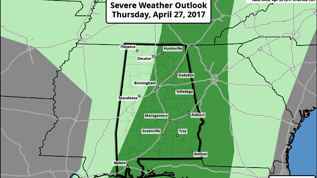
STORMY START TO THURSDAY: That batch of storms is expected to push into Alabama very early Thursday morning, during the pre-dawn hours. The latest high-resolution North American Mesoscale model suggests the line of storms will be passing through the Birmingham metro area around 5 a.m., and then moving into East Alabama by 7 a.m. These storms could produce strong straight-line winds and some hail, and the Storm Prediction Center has the eastern two-thirds of Alabama in a “marginal risk” of severe weather Thursday.

The early-morning timing for the storms hopefully will mitigate the overall severe weather threat. There’s some chance a few new storms could fire over far East Alabama by afternoon as the air heats up and becomes unstable. But, for now, it looks like the main window for storms Thursday in Alabama will come from 2 a.m. until 10 a.m.
FRIDAY/SATURDAY: These two days will be very warm and mostly dry. But the air will also be very unstable, and I think we need to mention the risk of a few isolated afternoon storms both days out of respect for the very high forecast CAPE values. The high Friday will be in the mid 80s, followed by upper 80s Saturday.
MORE STORMS ARRIVE SUNDAY: A significant severe weather event will unfold west of Alabama Friday into Saturday, and these storms will likely push into Alabama Sunday. SPC has the western part of the state in a severe weather risk on its outlook for Sunday, but it is simply too early to determine the timing and magnitude of the severe weather threat. We need to get past Thursday’s event before we focus too much on Sunday. At the moment is looks like the main window for the heavier storms will come from noon until midnight.
NEXT WEEK: Cooler, drier air returns to Alabama Monday, and the first half of the week looks nice, with pleasant days and cool nights. The next round of storms is set to arrive late in the week.

Click here to see the Beach Forecast Center page.
WEATHER BRAINS: You can listen to our weekly 90-minute netcast anytime on the web, or on iTunes. This is the show all about weather featuring many familiar voices, including meteorologists at ABC 33/40.
CONNECT: You can find me on all of the major social networks:
Facebook
Twitter
Google Plus
Instagram
Pinterest
Snapchat: spannwx
For more weather news and information, visit AlabamaWX.


