James Spann: Strong storms move into Alabama late tonight
James Spann: Warm, dry day before the storms in Alabama from Alabama NewsCenter on Vimeo.
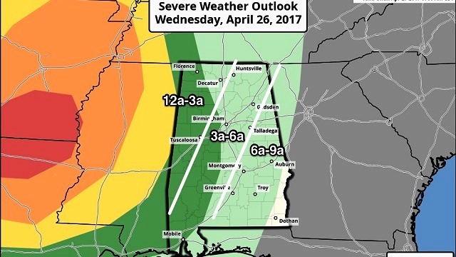
WARM, DRY DAY AHEAD: We expect a good supply of sunshine across Alabama today with a high up in the mid 80s this afternoon. But, to the west, severe thunderstorms will form, and the Storm Prediction Center has defined a “moderate risk” of severe storms for parts of North Louisiana and South Arkansas. Those storms will enter far West Alabama around midnight tonight, and we have a “marginal risk” defined for the western counties of our state in the “Day 1” outlook that runs through 7 a.m. tomorrow.

In the SPC “Day 2” outlook for tomorrow that begins at 7 a.m., there is a “marginal risk” defined for roughly the eastern half of the state.

The primary limiting factors for severe weather in Alabama will be the lack of instability, and that the main upper support will be passing to the north of the state. But there will be a significant amount of shear, and strong to severe storms are possible.
TIMING: The window for strong to severe storms will come from midnight tonight through 9 a.m. tomorrow. The line enters far West Alabama around midnight, and it pushes out of the state by midmorning. The storms should be in the Birmingham metro sometime between 3 and 6 a.m.
THREATS: Heavier storms could produce small hail and strong straight-line winds. An isolated small tornado can’t be ruled out.
RAIN: Rain amounts of around one-half inch are likely; no flooding issues.
The sky becomes partly to mostly sunny tomorrow afternoon as drier air returns; the high will be between 77 and 80 degrees.
FRIDAY/SATURDAY: These days will be almost summer-like, with afternoon highs between 87 and 90 degrees. The sky will be partly sunny, and we will mention only isolated afternoon and evening thunderstorms. Most communities will be dry.
To the west, a significant severe weather event will unfold on these two days.
STORMY SUNDAY: The storm system to the west will push strong to severe thunderstorms into Alabama at some point Sunday. For now it looks like the main event will come between noon and midnight. It is simply too early to know the magnitude of the threat or the modes of severe weather to expect. Once we get the storms out of here tomorrow morning, we will get focused on the Sunday event.
It does look like beneficial rain will fall Sunday, with amounts at least in the 1- to 2-inch range.
NEXT WEEK: Monday and Tuesday look dry and pleasant, with highs in the 70s and lows in the 50s; colder pockets should be in the 40s early Tuesday morning. The next chance of showers and storms will come later in the week, most likely on Thursday.

Click here to see the Beach Forecast Center page.
WEATHER BRAINS: You can listen to our weekly 90-minute netcast anytime on the web, or on iTunes. This is the show all about weather featuring many familiar voices, including meteorologists at ABC 33/40.
CONNECT: You can find me on all of the major social networks:
Facebook
Twitter
Google Plus
Instagram
Pinterest
Snapchat: spannwx
For more weather news and information, visit AlabamaWX.