James Spann: Clearing, windy, cooler today in Alabama
James Spann: Storms moving out, cooler air moving into Alabama today from Alabama NewsCenter on Vimeo.
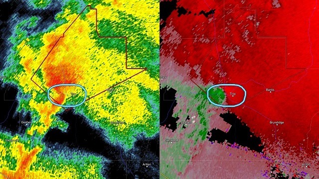
RADAR CHECK: We still have lingering showers and a few thunderstorms over the eastern half of Alabama early this morning; even a few severe storms over southeast Alabama. A tornado warning was issued for Pike County around 6:15.

Rain will exit the state by midmorning, and the sky becomes partly to mostly sunny by afternoon as cooler, drier air flows into the state. There is a tight surface pressure gradient in place, meaning strong west winds in the 15 to 30 mph range, with gusts to 40 mph in spots. The National Weather Service had a wind advisory in effect for much of Alabama today. Hang on to your hat.
Tonight will be clear and cool with diminishing wind; cooler spots will visit the 40s early tomorrow morning. Then, during the day tomorrow, expect sunshine in full supply with an afternoon high in the 77- to 80-degree range.
MORE RAIN LATER THIS WEEK: The day Wednesday looks dry and warm, with a mix of sun and clouds and a high in the low 80s. Then, clouds return quickly Wednesday evening, and we will mention periods of rain with a few thunderstorms Wednesday night and Thursday. A deepening surface low will pass north of Alabama with decent upper support, which is usually a favorable setup for severe storms in early May. But there is very little instability, and accordingly the Storm Prediction Center for now does not have a severe weather risk defined for Thursday.
Rain amounts of 1 inch are likely with this event; some spots could see more. The rain should end Thursday night as the system lifts northeast.
FRIDAY AND THE WEEKEND: Friday looks like a windy, cool day with slow clearing; a very good chance we won’t get out of the 60s. Saturday morning looks downright chilly as the weekend begins; the Global Forecast System is hinting at low 40s for Birmingham, meaning colder spots across north and central Alabama could actually drop into the upper 30s. The rest of the weekend looks delightful, with sunny days; the high Saturday will be close to 70, followed by 80-degree warmth Sunday afternoon.
NEXT WEEK: A blocked upper air pattern over the nation should bring fairly tranquil weather to Alabama for much of the week, with temperatures at, or maybe a bit below, seasonal averages.

Click here to see the Beach Forecast Center page.
WEATHER BRAINS: You can listen to our weekly 90-minute netcast anytime on the web, or on iTunes. This is the show all about weather featuring many familiar voices, including meteorologists at ABC 33/40. We will produce this week’s show tonight at 8:30. You can watch it live here.
CONNECT: You can find me on all of the major social networks:
Facebook
Twitter
Google Plus
Instagram
Pinterest
Snapchat: spannwx
For more weather news and information, visit AlabamaWX.


