James Spann: Scattered showers/storms stay in the forecast for Alabama
RADAR CHECK: Most of the showers and thunderstorms on radar this afternoon are south of I-20. Heavy downpours are concentrated along the U.S. 80 corridor, Demopolis to Selma to Montgomery.

Away from the storms, we have a mix of sun and clouds with temperatures mostly in the low to mid 80s. Scattered showers and storms will fade away once the sun goes down.
TOMORROW/THURSDAY: Not much change. Moist air covers Alabama, and we will deal with random, scattered showers and thunderstorms most days. There will be some good intervals of sunshine, and afternoon highs will be mostly in the mid 80s, right at seasonal averages for early June.
THE WEEKEND: The weather just won’t change much. Mixed sun and clouds Saturday and Sunday, with highs in the mid 80s, and scattered showers and thunderstorms. There’s no way of knowing exactly when and where storms will pop up; the chance of any one spot getting wet is about 1 in 3 Saturday and 50/50 Sunday. Humidity levels stay high.
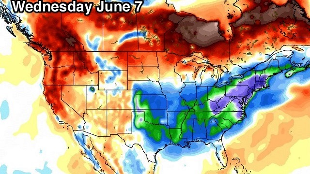
NEXT WEEK: Showers and storms are likely Monday as a surface front approaches Alabama from the west, and global models continue to suggest we will get into drier continental air Tuesday through Thursday. This means no rain on these three days, with lower humidity levels and cooler nights.

BEACH FORECAST: Click here to see the AlabamaWx Beach Forecast Center page.
WEATHER BRAINS: You can listen to our weekly 90-minute netcast anytime on the web, or on iTunes. This is the show all about weather featuring many familiar voices, including meteorologists at ABC 33/40.
CONNECT: You can find me on all of the major social networks:
Facebook
Twitter
Google Plus
Instagram
Pinterest
Snapchat: spannwx
For more weather news and information, visit AlabamaWx.


