James Spann: Alabama gets tropical rain, heavy at times, through Thursday
WHAT DROUGHT? Not that long ago we were in the midst of an exceptional drought across much of Alabama, but that is a distant memory today as the concern shifts to flooding. On radar this afternoon, widespread rain covers the southern half of Alabama, with scattered showers to the north along the I-20 corridor.
A stalled surface front just north of I-20 will drift northward, and much of Alabama will be in an airmass with copious amounts of deep tropical moisture in coming days, setting the stage for a big June rain event.
CINDY IS ON THE BOARD: The disturbance in the Gulf was upgraded to Tropical Storm Cindy this morning, but there is no change in the expected impact to the coastal region and the Deep South. Cindy has sustained winds of 45 mph, and little additional strengthening is expected because of strong shear across the Gulf; most of the storms are well east of the exposed center on visible satellite images this afternoon. The center should reach the coast near the Sabine Pass (the Texas/Louisiana border) Thursday morning.
But, as discussed here often, do not focus on the track of the low pressure center. The heaviest rain will be well to the east; in fact, flooding is possible out to 600 miles east of the storm center over the next few days. Flash flood watches are up for much of Louisiana, south Mississippi, south Alabama, the Florida Panhandle and southwest Georgia. A flash flood watch is also up for north Georgia; flash flooding is in progress in part of the Atlanta metro area this afternoon as moisture from Cindy combines with a stalled surface front.

IMPACT ON NORTH/CENTRAL ALABAMA: We expect periods of rain, and possibly a few thunderstorms, tonight through Thursday. The rain will be heavy at times, and flooding is very possible. I would not be surprised if a flash flood watch is issued at some point tonight or tomorrow. Rain amounts of 3 to 4 inches are likely, with isolated amounts to 5 inches.
We should mention a few isolated tornadoes are possible across north and central Alabama Thursday as Cindy moves inland; the tornadoes associated with a tropical system like this tend to be fairly small and short-lived, but they are still dangerous.
Scattered to numerous showers and storms are still possible on Friday.
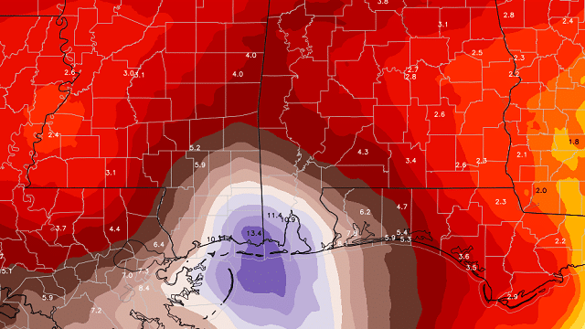
IMPACT ON THE GULF COAST: Rain amounts of 10 to 15 inches are possible on the Alabama Gulf Coast as a deep fetch of tropical moisture is pointed right at Mobile Bay, on the east side of Cindy. Very significant flooding issues will likely develop between now and Thursday, so TURN AROUND, DON’T DROWN. Do not drive through any flooded roadway; this is a potentially dangerous situation.

The flood threat extends from southeast Louisiana all the way over to near Apalachicola. Most coastal cities will see at least 5 inches of rain.
Also, a few waterspouts and tornadoes are possible. A waterspout moved inland near St. George Island, Florida, this morning as a tornado; I have not heard of any damage.
The surf is extremely rough, and rip currents continue. Double flags are flying on the Alabama coast; the water is closed. Don’t even think about going in the Gulf water through Thursday night.
Weather conditions improve Friday, with showers becoming more scattered in nature, and returning sunshine. We expect fairly routine summer weather Saturday and Sunday on the central Gulf Coast, with a partly sunny sky both days and the usual risk of scattered storms.
BRET: Tropical Storm Bret, now in the southern Caribbean, is expected to dissipate later this week in the open water of the western Caribbean because of shear. The rest of the Atlantic basin is quiet.
NEXT WEEK: The weather will be much drier as continental air drops in from the north; for now, it looks like most communities across north and central Alabama will be shower-free Monday through Wednesday. Moist air begins to return late in the week.
SOLSTICE TONIGHT: With all the tropical weather, the summer solstice occurring at 11:24 p.m. tonight has been lost in the shuffle. But summer officially begins at that moment.
BEACH FORECAST: Click here to see the AlabamaWx Beach Forecast Center page.
WEATHER BRAINS: You can listen to our weekly 90-minute netcast anytime on the web, or on iTunes. This is the show all about weather featuring many familiar voices, including meteorologists at ABC 33/40.
CONNECT: You can find me on all of the major social networks:
Facebook
Twitter
Google Plus
Instagram
Pinterest
Snapchat: spannwx
For more weather news and information, visit AlabamaWx.