Brian Peters: Showers more numerous for Alabama the next couple of days
Brian Peters: More showers on the way for Alabama from Alabama NewsCenter on Vimeo.
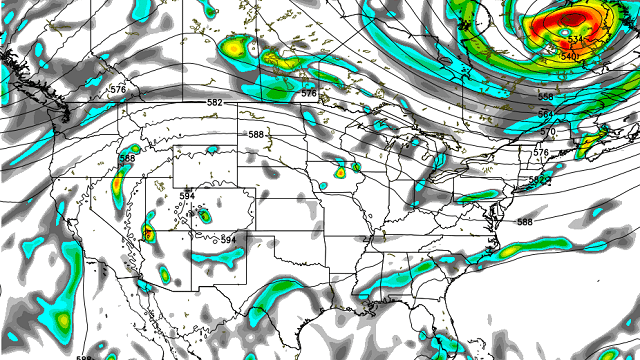
TODAY: Much of Alabama is waking up to clear skies, with some patchy fog reducing visibilities to around 1 mile. Three very small showers were occurring this morning in Tuscaloosa County. There is not much change to the overall upper air pattern today, with a trough over the eastern half of the country and a ridge over the western U.S. Precipitable water values increase somewhat across the western sections of Alabama. The southern half is likely to remain mainly shower free, while isolated showers occur across the northern third. Highs in central Alabama should again reach the lower 90s.
THURSDAY AND FRIDAY: While showers are expected to remain isolated today, a weak frontal boundary currently north of Alabama will settle into our area Thursday and Friday. Earlier in the week I was optimistic that the front might bring some drier air to our region, but that is looking much less likely now. I do believe the frontal boundary will sag into north and central Alabama on Thursday and Friday. I think the presence of this boundary, along with increased precipitable water values, will lead to more numerous showers and thunderstorms for those days. The frontal boundary begins to wash out into the weekend.
TROPICS: In the Atlantic, we’re still keeping a close eye on the area of disturbed weather in the south central Atlantic. There is a window for this system to become better organized, but after a couple of days, it will enter a region where conditions are less conducive, so if it is going to do something, it needs to be in the next couple of days. In the eastern North Pacific, there are three areas with the potential for development, but fortunately all of these are moving away from land.
 THE WEEKEND AND NEXT WEEK: We maintain the troughiness over the eastern part of the country over the weekend, but the strength of the trough begins to wane some by Monday. Tuesday and Wednesday, the strong upper ridge to the west will nose into the Middle Mississippi River Valley. This will have little impact on the weather for central Alabama, with highs continuing to dance around the 90-degree mark and daily chances for showers and thunderstorms. Precipitable water values will be fairly high starting the first of next week, so we’ll have to be aware of the potential for heavy downpours that could result in localized flash flood issues.
BEACH FORECAST: The weather at the beach will include the possibility of a passing shower just about every day for the next seven days, with highs in the upper 80s. There is no indication of any all-day rain situation, so you should be able to enjoy the beach with only short interruptions for a passing shower. Please heed those showers and don’t become a lightning statistic. The rip current threat is low for the next couple of days. Click here to see the AlabamaWx Beach Forecast Center page.
ONE A DAY: Just a quick reminder for regular readers — we will be on a one-a-day posting schedule until Monday, July 10, when James Spann returns from vacation. Enjoy your day and Godspeed.
For more weather news and information, visit AlabamaWx.


