James Spann: Muggy air coats Alabama, with scattered showers, storms
James Spann: Another day of showers and storms for parts of Alabama from Alabama NewsCenter on Vimeo.
RADAR CHECK: We have showers on radar early this morning over parts of east Alabama; heavier ones are over Tallapoosa and Chambers counties at daybreak. Expect a mix of sun and clouds again today, with more showers and storms firing up during the peak of the daytime heating process this afternoon and this evening. Deeper moisture will be over the southern two-thirds of the state, so the most numerous thunderstorms should be along and south of I-20. Showers to the north will be more widely spaced. We expect a high today between 88 and 91 degrees.
Like yesterday, storms that form won’t move much and some spots could see heavy rain. The official rain total yesterday in Birmingham (based on data at the airport) was 3.64 inches, making it the wettest day since Christmas Day 2015. But just down the road at the Shelby County Airport between Alabaster and Calera, the total was 0.00 inches. So it goes with storms on summer afternoons in Alabama.
TOMORROW: The air aloft should be a little warmer, and the air a bit more stable. So we will forecast a decent amount of summer sunshine with only isolated storms; afternoon temperatures could very well creep up into the mid 90s.
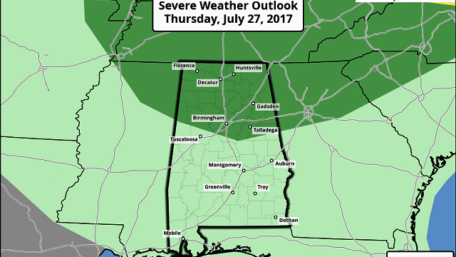
THURSDAY/FRIDAY: A surface front will slowly approach from the north, and the coverage of scattered showers and thunderstorms should increase on these two days. We note the Storm Prediction Center has roughly the northern half of Alabama in a marginal risk of severe storms on Thursday.

Some of the heavier storms could produce strong, gusty winds, torrential rain and lots of lightning. The high Thursday will be in the 92- to 95-degree range, but by Friday maximum temperatures will slip into the upper 80s.
THE ALABAMA WEEKEND: The front will continue to drift southward; the best chance of showers and storms Saturday should be along and south of I-20; drier air will filter into the northern third of the state. Then, on Sunday, a relatively dry airmass will cover much of north and central Alabama with only isolated showers around. Highs both days will be in the 87- to 90-degree range, which is below average for late July in Alabama.
NEXT WEEK: Moist air returns Monday, and the week looks fairly routine for early August; partly sunny days with scattered, mostly afternoon and evening showers and thunderstorms. Temperatures should remain a little below average, however, with highs in the upper 80s most days. The Climate Prediction Center continues to suggest below-average temps Aug. 1-7.

TROPICS: The Atlantic basin is very quiet, and tropical storm formation is not expected over the next five days.
BEACH FORECAST: Click here to see the AlabamaWx Beach Forecast Center page.
WEATHER BRAINS: You can listen to our weekly 90-minute netcast anytime on the web, or on iTunes. This is the show all about weather featuring many familiar voices, including meteorologists at ABC 33/40.
CONNECT: You can find me on all of the major social networks:
Facebook
Twitter
Google Plus
Instagram
Pinterest
Snapchat: spannwx
For more weather news and information, visit AlabamaWx.


