James Spann: Drier air arrives in Alabama over the weekend
RADAR CHECK: So far this afternoon, showers have been few and far between across Alabama, but we will maintain the chance of scattered storms through tonight as a moist air mass hangs over the state and a surface front approaches from the north. Temperatures are mostly in the 88- to 91-degree range.
TOMORROW: That front could very well push showers and storms in here tomorrow morning; we will lean in that direction in our forecast. It won’t rain everywhere, but some spots could see a decent shower before noon. Then, drier air and lower dew points ease in here from the north during the afternoon. The high tomorrow will be close to 90 degrees.
THE ALABAMA WEEKEND: For now, it looks like a generally rain-free weekend for the northern two-thirds of the state. The chance of a shower isn’t zero, but it is clearly less than 10 percent both Saturday and Sunday. Humidity values will be a bit lower, but afternoon heat levels will be a little higher as the dry air will heat more effectively. Highs over the weekend will be in the 92- to 95-degree range, as we finally get a touch of the August heat we expect this time of the year.
ECLIPSE MONDAY: It sure looks like the air will remain relatively dry for August, meaning good conditions for eclipse viewing. The sky will be partly to mostly sunny with a field of cumulus clouds, and only a small risk of a few isolated showers from noon until 3 p.m. But please remember you can’t look at the eclipse with the naked eye; have the right eyewear, or watch our coverage on ABC 33/40.
REST OF NEXT WEEK: We will bring back the chance of scattered showers and thunderstorms Tuesday and Wednesday, but the Global Forecast System is suggesting another shot of drier air will arrive Thursday and Friday. Highs will be pretty close to 90 through much of the week.
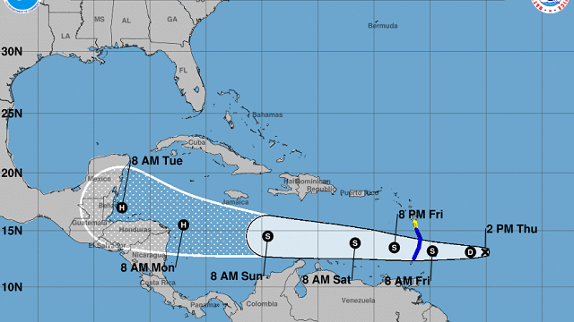
TROPICS: “Potential Tropical Cyclone Nine” should become Tropical Storm Harvey over the next 24 hours; it will pass through the Windward Islands tomorrow and move through the Caribbean. The National Hurricane Center hints this could become a hurricane in the far western Caribbean early next week.
“Invest 92L” trails TC 9 and could become a tropical depression or storm within the next two days (the name will be “Irma” if it happens). This one is expected to approach the Bahamas in five days, staying north of the Caribbean. Most models suggest weakening or dissipation then because of harsh environmental conditions. It’s just too early to know if this will be an issue for the U.S.
One more wave is in the eastern Atlantic and should be classified as “Invest 93L” soon. Any development in the short term with this feature will be slow.
BEACH FORECAST: Click here to see the AlabamaWx Beach Forecast Center page.
WEATHER BRAINS: You can listen to our weekly 90-minute netcast anytime on the web, or on iTunes. This is the show all about weather featuring many familiar voices, including meteorologists at ABC 33/40.
CONNECT: You can find me on all of the major social networks:
Facebook
Twitter
Google Plus
Instagram
Pinterest
Snapchat: spannwx
For more weather news and information, visit AlabamaWx.


