James Spann: Alabama moisture levels rise; Harvey headed for Texas
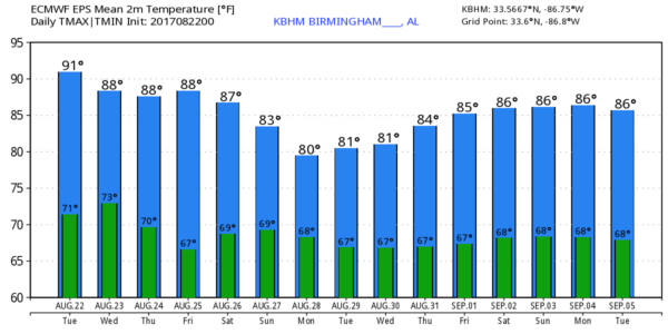
MOISTURE LEVELS SLOWLY RISING: As expected, we had a great day yesterday for solar eclipse viewing across the northern two-thirds of Alabama, but moisture levels begin to rise today, and a few spots could see a passing shower or thunderstorm this afternoon. Otherwise, today will be partly sunny with a high in the low 90s.
Showers and storms will increase tomorrow as a surface front approaches from the north. The sky will be occasionally cloudy, and the high should drop back into the upper 80s.
THURSDAY/FRIDAY: Models are now in good agreement that drier air will slip down into the northern half of the state, with most of the showers and storms over the southern counties. For places like Birmingham, Tuscaloosa, Anniston and Gadsden, it looks generally dry both days with a good supply of sunshine and highs in the upper 80s.
THE ALABAMA WEEKEND: We will bring back some risk of scattered showers and storms on Saturday, and beyond that the weather will all depend on the tropical situation. The remnant circulation of Tropical Storm Harvey is expected to move northeast toward Alabama, and the Global Forecast System hints that we could very well see a wet day on Sunday, with fairly widespread rain and possibly a few thunderstorms. We need to mention there is great uncertainty, needless to say, since Harvey at this point is a disorganized tropical wave over the Yucatan Peninsula. But we will lean toward a much higher chance of rain statewide on Sunday.
A tropical rain event will likely continue into Monday, followed by cooler, drier air. Global models suggest we could very well see a nice preview of fall after the passage of the tropical system.
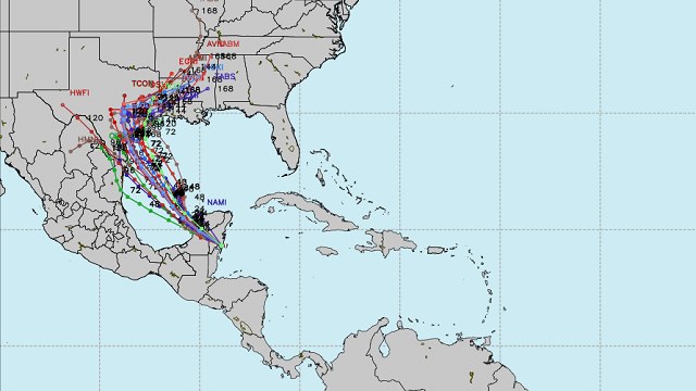
HARVEY COMES BACK: The remnant circulation, formerly Tropical Storm Harvey, is over Yucatan this morning, but it is expected to organize quickly over the Bay of Campeche tonight and tomorrow. Models now bring the system toward the Texas Gulf Coast with potential landfall Friday as a tropical storm or maybe even a category one hurricane. The main issue for the Texas coast, most likely, will come from heavy rain and flooding. It’s too early to specify a landfall point; there is still some model disagreement. The European model brings Harvey up toward South Padre Island, while the GFS and North American Mesoscale (NAM) have a higher-latitude system.
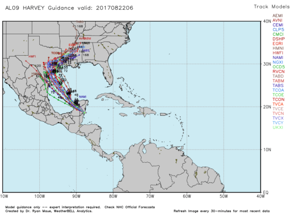
After landfall, Harvey will curve northeast and bring lots of rain to Louisiana and Mississippi, and perhaps Alabama by Sunday and Monday.
INVEST 92L: A broad tropical low is close to the Bahamas this morning; there could be some slow development in coming days as it meanders around. The main impact will be rain for parts of the Florida Peninsula; ultimately this one will head out to sea in five to seven days as a deep upper trough forms over the eastern United States.
The rest of the Atlantic basin is fairly quiet.
BEACH FORECAST: Click here to see the AlabamaWx Beach Forecast Center page.
WEATHER BRAINS: You can listen to our weekly 90-minute netcast anytime on the web, or on iTunes. This is the show all about weather featuring many familiar voices, including meteorologists at ABC 33/40.
CONNECT: You can find me on all of the major social networks:
Facebook
Twitter
Google Plus
Instagram
Pinterest
Snapchat: spannwx
For more weather news and information, visit AlabamaWx.


