James Spann: Another chilly night ahead for Alabama
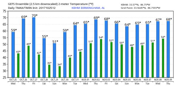
GOLDEN DAYS OF FALL: It doesn’t get much better — a cobalt blue sky, excellent visibility, low humidity and a fresh northwest wind across Alabama today. Temperatures are more than 10 degrees below average in most places with readings around 60 degrees at mid-afternoon. Tonight will be clear and cold, with lows between 38 and 44 for most places.
TOMORROW/FRIDAY: Tomorrow will be sunny and warmer with a high in the low 70s. Dry conditions continue during the day Friday with a partly sunny sky; Friday’s high will be in the 71- to 75-degree range. Clouds will increase late in the day ahead of a cold front.
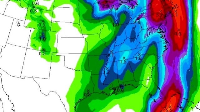
Looks like showers could form over the western half of Alabama in the 6 to 9 p.m. time frame Friday, but the most widespread rain associated with the cold front will arrive after 10 p.m. Some thunder is possible overnight Friday night into early Saturday morning, but severe weather is not expected. Rain amounts of one-half to 1 inch look likely.
THE ALABAMA WEEKEND: The coldest air so far this season rolls into the state Saturday. It will be a cloudy, windy, cold, blustery and damp day. Rain will end from west to east during the midday hours, but clouds linger through the afternoon. It looks like we will hold in the 47- to 51-degree range throughout the day, with lower wind chill values. We drop into the mid 30s early Sunday with a clearing sky; widespread frost isn’t especially likely Sunday morning because of northwest winds of 10 to 15 mph.
During the day Sunday, the sky will be sunny with a high in the upper 50s, about 10 to 15 degrees below average for late October in Alabama.
MONDAY MORNING FROST/FREEZE: The wind calms down Sunday night, and Monday morning will feature a low between 28 and 34 degrees for most communities, with widespread frost likely. Growers beware. Colder pockets will see a freeze, with temperatures in the mid to upper 20s.
FOOTBALL WEATHER: For the high school games across north and central Alabama Friday night, we will need to mention the risk of showers over the western half of the state. Stadiums east of I-65 should be dry, with the bulk of the rain holding off until late night. The sky will be cloudy with temperatures falling from the upper 60s at kickoff to near 60 by the final whistle.
The annual Magic City Classic (Alabama State vs Alabama A&M) kicks off Saturday at 2:30 at Legion Field. It will be cloudy, windy and cold, with temperatures hovering in the upper 40s during the game. Most of the rain should end by kickoff, but some drizzle could linger at times during the game.
UAB plays Southern Mississippi at Hattiesburg Saturday (6 p.m. kickoff). The weather will be breezy and cold, with temperatures falling from 55 at kickoff into the upper 40s by the fourth quarter. Rain over South Mississippi should end well before kickoff.
Jacksonville State will host Southeast Missouri State Saturday (3 p.m. kickoff). Some rain is likely during the first half; otherwise, it will be cloudy, windy and cold, with temperatures in the upper 40s and wind chill index values close to 40 degrees. Bundle up.
REST OF NEXT WEEK: Tuesday will be dry with a high in the 60s; Some rain could return late Wednesday and Wednesday night ahead of another surface boundary.
TROPICS: A disturbance in the western Caribbean, near the coast of Central America, has a medium chance of becoming a tropical depression within five days. This tropical low should ride up the cold front near the U.S. East Coast this weekend, enhancing rain totals there. The rest of the Atlantic basin is quiet.
BEACH FORECAST: Click here to see the AlabamaWx Beach Forecast Center page
WEATHER BRAINS: You can listen to our weekly 90-minute netcast anytime on the web, or on iTunes. This is the show all about weather featuring many familiar voices, including meteorologists at ABC 33/40.
CONNECT: You can find me on all of the major social networks:
Facebook
Twitter
Google Plus
Instagram
Pinterest
Snapchat: spannwx
For more weather news and information from James Spann and his team, visit AlabamaWx.


