James Spann: Warmer days ahead for Alabama
Weather for October 30, 2017
James Spann: Cold morning, then a warmup for Alabama from Alabama NewsCenter on Vimeo.
FRIGID MORNING: Many north and central Alabama communities are experiencing their first freeze of the season this morning. Some temperatures just before daybreak:
- Black Creek — 26 (Vic has been below freezing for nine hours so far)
- Valley Head — 27
- Fort Payne — 28
- Gadsden — 30
- Russellville — 30
- Pell City — 30
- Cottondale — 30
- Concord — 31
- Cullman — 31
- Haleyville — 31
- Heflin — 31
- Alexander City — 31
- Chelsea — 32
- Anniston — 32
- Sylacauga — 32
- Albertville — 32
Frost is reported down in deep south Alabama, with 30s as far south as parts of Mobile and Baldwin counties.
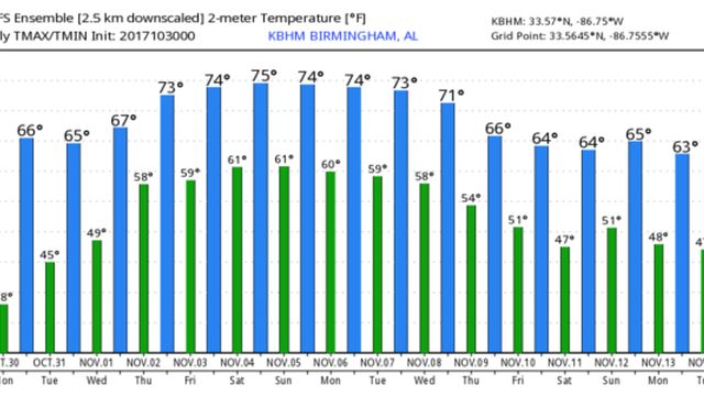
We rise into the mid to upper 60s later today with ample sunshine, still below the average high of 71 for Oct. 30 (for Birmingham). Tonight will be clear and not as cold as recent nights; most places will see a low in the 40s early tomorrow, with upper 30s for colder spots.
HALLOWEEN: Looking good; the day tomorrow will be partly sunny with a high between 65 and 68. For trick or treaters, the sky will be mostly fair tomorrow evening with temperatures falling from near 59 at 6 to 55 at 10. Pleasantly cool, and dry.
WEDNESDAY THROUGH FRIDAY: The moisture level will increase, and we will bring in the chance of showers on these three days, primarily from Birmingham north and west — nothing too heavy or widespread, and communities south and east of Birmingham, most likely, will stay dry. The sky will be occasionally cloudy and afternoon temperatures rise into the 70s.
THE ALABAMA WEEKEND: Not much change Saturday; we will maintain the chance of showers over about the northern half of the state with cloudy periods, along with a high in the 70s. Then, on Sunday, just the chance of a few isolated showers with a mix of sun and clouds. Temperatures peak in the mid 70s Sunday afternoon.
NEXT WEEK: The pattern, generally speaking, looks pretty quiet, with a ridge over the Gulf of Mexico; highs will be mostly in the 70s with no significant rain at least for the first half of the week. The good news is that we see no risk of severe weather into mid-November; our late fall tornado season kicks off Wednesday.
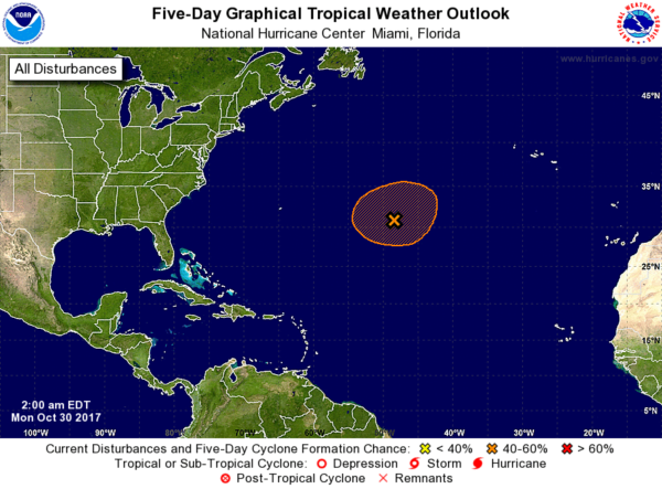
TROPICS: Over the weekend Tropical Storm Philippe underperformed and dissipated east of Florida. This morning the National Hurricane Center is watching a disturbance over the central Atlantic with a medium chance of becoming a tropical or subtropical storm this week, but if anything forms there it will remain well east of the United States.
BEACH FORECAST: Click here to see the AlabamaWx Beach Forecast Center page.
WEATHER BRAINS: You can listen to our weekly 90-minute netcast anytime on the web, or on iTunes. This is the show all about weather featuring many familiar voices, including meteorologists at ABC 33/40. We will produce this week’s show tonight at 8:30. You can watch it live here.
CONNECT: You can find me on all of the major social networks:
Facebook
Twitter
Google Plus
Instagram
Pinterest
Snapchat: spannwx
For more weather news and information from James Spann and his team, visit AlabamaWx.


