James Spann: Much cooler air arrives in Alabama Wednesday
James Spann from Alabama NewsCenter on Vimeo.
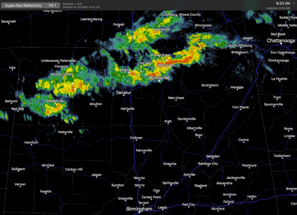
RADAR CHECK: A band of showers and a few thunderstorms is over far north Alabama early this morning; these showers are expected to dissipate over the next few hours as they move east/southeast..
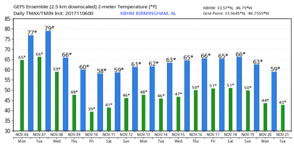
Today will be another mild November day with more clouds than sun; the high will be in the mid 70s for most communities. The average high for Nov. 6 (for Birmingham) is 69. Showers this afternoon and tonight should be few and far between.
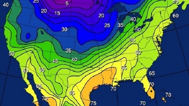
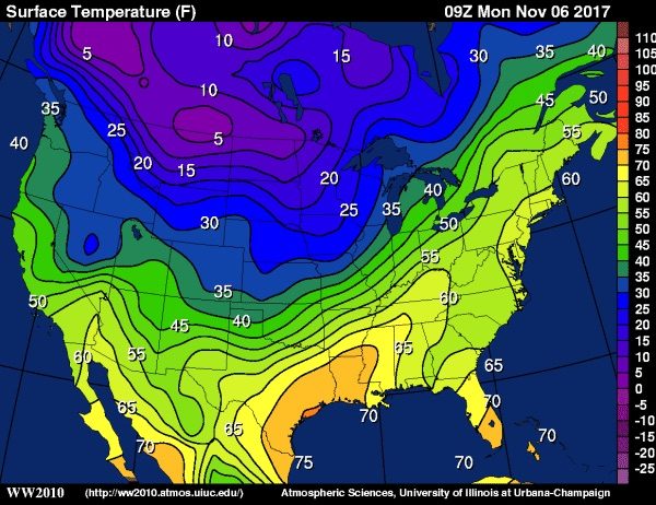
HUGE CONTRAST: Quite the thermal contrast across the nation this morning — Lewiston, Montana, reported 5 degrees at 5 a.m. Central; Houston, Texas, at the same time reported 75.
A cold front, representing the leading edge of that colder air over the northern half of the U.S., will approach tomorrow, and bring showers and a few thunderstorms by afternoon and tomorrow night. No severe weather is expected. The weather stays mild with a high in the mid 70s.
MUCH COOLER WEDNESDAY: Looks like temperatures will hold in the 50s most of the day Wednesday with clouds and periods of rain as a wave of low pressure moves along the front over south Alabama. Rain is also a good possibility Wednesday night; rain amounts of 1 to 2 inches are expected over the northern half of the state.
THURSDAY/FRIDAY: Rain ends very early Thursday morning; the sky becomes partly to mostly sunny with a high at or just over 60 degrees. Friday looks like a delightful fall day with ample sunshine; we begin the day in the 38- to 42-degree range, followed by a high in the mid 60s.
THE ALABAMA WEEKEND: Saturday will be sunny with a high in the 60s; some clouds will creep into the state from the east Sunday, but for now the day looks dry with highs holding in the 60s.
NEXT WEEK: Cool, dry weather should continue for at least the first half of the week. We see no sign of any severe weather issues across the Deep South for the next 10 days.
TROPICS: Tropical Depression 19 has formed over the central Atlantic; it should become Tropical Storm Rina later today. No threat to land.
BEACH FORECAST: Click here to see the AlabamaWx Beach Forecast Center page.
WEATHER BRAINS: You can listen to our weekly 90-minute netcast anytime on the web, or on iTunes. This is the show all about weather featuring many familiar voices, including meteorologists at ABC 33/40. We will produce this week’s show tonight at 8:30. You can watch it live here.
CONNECT: You can find me on all of the major social networks:
Facebook
Twitter
Google Plus
Instagram
Pinterest
Snapchat: spannwx
For more weather news from James Spann and his team, visit AlabamaWx.


