Brian Peters: Cold Christmas Day in Alabama

Brian Peters: Cold Christmas Day in Alabama from Alabama NewsCenter on Vimeo.
Merry Christmas from all of us at AlabamaWx.com.
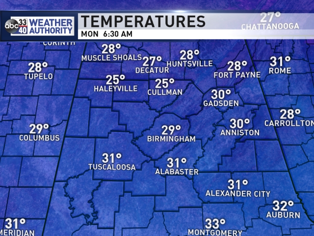
The sky cleared out overnight, but with a very fast flow aloft, more clouds streamed into the northern half of Alabama by early morning. With solid cold air advection occurring, temperatures dropped into the upper 20s by sunrise over Central and North Alabama with many locations dipping into the middle 20s. Those clouds that moved in around 4 am provided some very pretty sunrises for this Christmas morning.
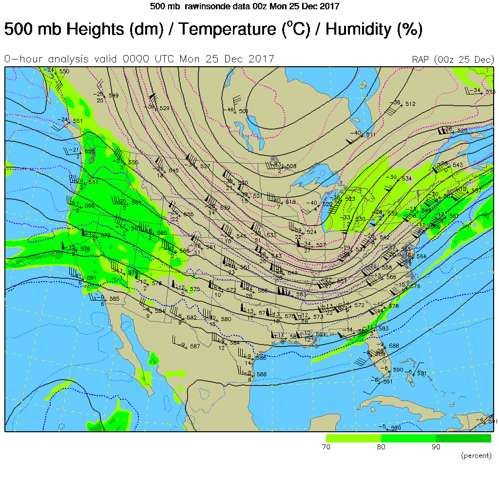
Look for a variation in cloud cover today as the fast flow with wind speeds of 70 to 115 mph across the Southeast US continues as we remain in the grips of a broad trough.
The watch/warning map clearly depicts the double storm situation this morning with winter weather advisories and warning from New York and Pennsylvania into New England along with winter weather advisories and warnings in the northern Rockies. Wind chill advisories covered a large part of the North Central US this morning as well. One solid benefit from the cold grip on the country is the lack of any severe weather risks.
There continued to be model differences in the week ahead, so confidence in the forecast is not especially high. The GFS and the European seemed to be adjusting closer to each other. My discussion is based primarily on the GFS with notes about the differences.
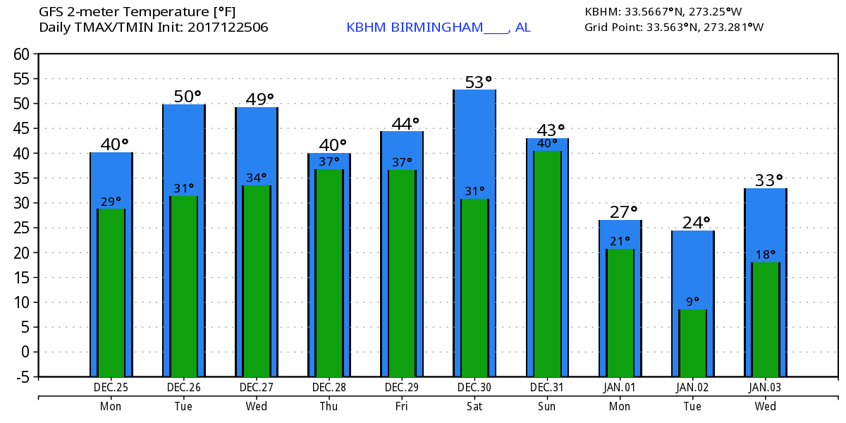
At the surface, high pressure settles into the Ohio and Tennessee River Valleys today and Tuesday while the upper flow remains configured with the broad trough over the eastern two-thirds of the country. By Wednesday the GFS is beginning to pick up on the southern stream coming out of the Baja California area. Both models start out with the potential for some overrunning rain on Wednesday, but the GFS is more bullish on keeping the rain around well into Thursday while the European dries us out much quicker. We should see a slight warm up for Tuesday and Wednesday with highs from 48 to 52.
As overrunning precipitation develops we’ll have to be keeping an eye on just how cold it is. Both models maintain the deepest cold air just north of Alabama, so for now it looks like we will experience just liquid precipitation. The problem will be having the colder air so close, it would not take much of a change to bring some winter weather issues further south.
By Friday, both models agree on sweeping the moisture out of the Southeast US as a strong trough moves through the Great Lakes toward the Mid-Atlantic states. This pattern should keep us somewhat chilly with lows in the 30s and highs in the 40s – possibly edging close to 50 degrees – for the latter part of the week.
The pattern stays cold and dry for Saturday, but the small trough that had been hanging back in the area of Baja California comes out across Mexico on Sunday bringing with it the potential for an overrunning situation again. Once again it looks like the precipitation will be liquid across much of the Southeast US, but the deeper cold air resides very close running from northern Arkansas across Tennessee. Once again, close enough to keep us on edge and a little wary of any small change to the pattern that could dig cold air further south. The highs over the weekend will be in the 40s with lows possibly in the 20s.
By Monday, New Years Day, another strong upper low digs into the Ohio River Valley providing yet another shot of cold air to start 2018. GFS MOS guidance numbers call for a low of 24 on January 1st in Birmingham with a high of only 32! That’s pretty cold for us and would be pretty close to a record. The coldest high for January 1st is 29 degrees in Birmingham. But we’re verging on voodoo country so we’ll carefully watch the trends in coming model runs before jumping on those numbers. But the trend to stay cold sure looks viable.
Looking out into voodoo country, the message remains clear that we will continue to see an active flow as a train of upper troughs march through the flow. The very end of the extended range looks very interesting, but we have to remember it is voodoo country.
Beach Forecast: Click here to see the AlabamaWx Beach Forecast Center page. The Beach Forecast is partially underwritten by the support of Brett/Robinson Vacation Rentals in Gulf Shores and Orange Beach. Click here to see Brett/Robinson’s Hot Deals now!
WeatherBrains: Don’t forget you can listen to our weekly 90 minute netcast anytime on the web, or on iTunes. This is the show all about weather featuring many familiar voices, including our meteorologists here at ABC 33/40.
Once again, Merry Christmas to everyone. I hope your Christmas Day 2017 is a good one for you and your families. Godspeed.
-Brian-
For more weather news and information from Brian Peters and the rest of the James Spann team, visit Alabama Wx.


