James Spann: Subfreezing nights ahead for Alabama
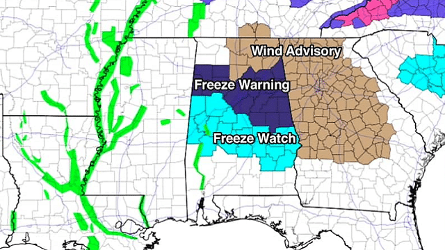
BREEZY, COOL MARCH DAY: As expected, we now have sunshine in full force across Alabama this afternoon following morning clouds and snow flurries. But temperatures are only in the low 50s with a chilly north wind of 15-25 mph. A freeze warning is in effect for north and central Alabama tonight; with a clear sky we project a low in the low 30s early tomorrow. The wind will stay up during the night, so we don’t expect much frost, and temperatures should be fairly uniform.
MIDWEEK: Dry weather continues through Thursday with sunny days and clear nights. Subfreezing lows are likely both Wednesday and Thursday morning; most places will see a low between 25 and 30 degrees; colder spots could see low 20s. The high tomorrow and Wednesday will be in the 50s; then a warming trend begins Thursday afternoon with a high in the mid to upper 60s.
FRIDAY AND THE WEEKEND: Moisture begins to return Friday, and we will mention a chance of showers late in the day and into Friday night. The day should be comfortable with a high close to 70. Then, for the weekend, expect generally cloudy conditions Saturday and Sunday with the threat of occasional showers and possibly a thunderstorm. This won’t be a total “washout,” but be ready for rain at times. We don’t expect any severe storms, and rain amounts should be in the one-half-inch to 1-inch range.
It’s just too early to be really specific about identifying timing for the main windows for rain over the weekend. The weekend will be mild, with highs in the 67- to 71-degree range.
NEXT WEEK: Mild, unsettled weather continues for at least the first half of the week, with mostly cloudy conditions and some risk of showers daily; highs will be in the 70s.

25 YEARS AGO TODAY: The great “Blizzard of 93” cranked up. That night, heavy snow and wind gusts to 50 mph produced “white out” conditions across much of the state; the official snow total at Birmingham was 13 inches. Other totals included 20 inches at Walnut Grove and 16 inches at Bessemer. Some snow drifts were more than 4 feet high. Some had no power for more than a week, and everything was totally shut down in the middle of March. We have a number of blog posts on AlabamaWx with memories of the generational storm.
BEACH FORECAST: Click here to see the AlabamaWx Beach Forecast Center page.
WEATHER BRAINS: You can listen to our weekly 90-minute netcast any time on the web or on iTunes. This is the show all about weather featuring many familiar voices, including meteorologists at ABC 33/40. We will produce this week’s show tonight at 8:30. You can watch it live here.
CONNECT: You can find me on all of the major social networks:
Facebook
Twitter
Google Plus
Instagram
Pinterest
Snapchat: spannwx
For more weather news and information from James Spann and his team, visit AlabamaWx.