James Spann: Alabama’s eyes on Alberto as subtropical storm creeps our way
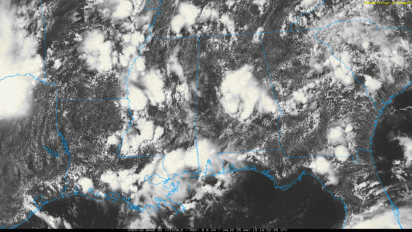
RADAR CHECK: It is the usual afternoon thunderstorm lottery across Alabama this afternoon. Some places are enjoying a sunny sky, while other places are dealing with heavy rain and some flooding caused by slow-moving, random, scattered storms.
Showers and storms will taper off tonight.
MEMORIAL DAY WEEKEND: The weather for north and central Alabama won’t change much Saturday and Sunday — warm, humid days with a mix of sun and clouds, and the risk of scattered showers and thunderstorms. Storms will be most active during the afternoon and evening hours, but we can’t rule out a late-night or morning shower in this kind of air mass. Highs both days will be in the 80s.
ALBERTO IS ON THE BOARD: Subtropical storm Alberto formed this morning over the Yucatan peninsula of Mexico. A subtropical storm is a hybrid between a classical warm-core tropical storm and a mid-latitude storm system, like the ones we see in the cool season.
Sustained winds are 40 mph, and the system will move up into the Gulf of Mexico over the holiday weekend. Steering currents will collapse and the system will just creep along Sunday and Monday toward the coast.

The current National Hurricane Center forecast has the center moving into the Mississippi coast Monday night. The system is expected to remain below hurricane strength, and it moves slowly northward through Mississippi Tuesday and Wednesday while weakening.
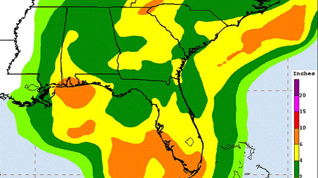
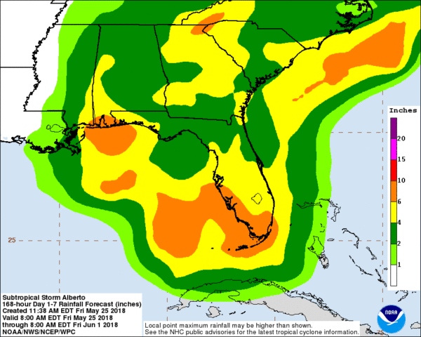
NORTH/CENTRAL ALABAMA: It looks like the main rain shield from Alberto won’t arrive until Tuesday, and the rain continues into part of the day Wednesday. Rain amounts of 2 to 4 inches are likely during the time, and some flooding is possible. We also can’t rule out an isolated tornado as we will be on the wet, unsettled east side of the system. The weather will trend drier Thursday and Friday as the remnant low moves well north of our state.
THE GULF COAST: The weather will be fine Saturday on the coast from Panama City Beach west to Gulf Shores, with about three to five hours of sunshine and a few scattered storms. Some sun is also possible Sunday; the main wind and rain associated with Alberto will arrive Sunday night and Monday.
Rain amounts of 6 to 10 inches are possible from Dauphin Island over to Destin Sunday night through Monday night, with potential for flooding.
Some key points:
- A few isolated tornadoes are possible on the Gulf Coast Sunday night and Monday.
- Dangerous rip currents will remain possible on the coast through Tuesday. Red flags are flying; stay out of the Gulf. The risk is simply not worth it.
- The weather will improve along the Gulf Coast beginning Tuesday afternoon, and the rest of the week looks fairly quiet with just the routine risk of scattered storms.
- There is always going to be some uncertainty involving tropical systems as they tend to have a mind of their own sometimes, so keep an eye out for forecast changes.
When I get the question “should I cancel my trip” to the coast, I remind them that various people have various reasons for going to the beach. I would not hesitate to go if it was me, but I don’t go to swim in the Gulf or soak up the sun. I am there to relax and enjoy some good seafood. The main impact from Alberto will come late Sunday through Monday night; otherwise, they will have just the routine scattered summer storms for the next seven days.
WEATHER BRAINS: You can listen to our weekly 90-minute netcast any time on the web, or on iTunes. This is the show all about weather featuring many familiar voices, including meteorologists at ABC 33/40.
CONNECT: You can find me on all of the major social networks:
Facebook
Twitter
Google Plus
Instagram
Pinterest
Snapchat: spannwx
For more weather news and information from James Spann and his team, visit AlabamaWx.


