James Spann: Alberto almost out of Alabama, but moist air remains
ALBERTO OVER NORTHWEST ALABAMA: The center of former Subtropical Storm Alberto is near Moulton this afternoon, moving northward. It will be in Tennessee tonight, but it has left a deep layer of tropical moisture over Alabama with very high precipitable water values.
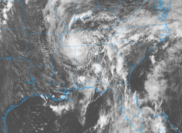
WEST SIDE??? Traditionally, with landfalling tropical systems on the Gulf Coast, the big rains and main impact are along and to the right (east) of the circulation center. All forecasts were drawn with that in mind yesterday, but Alberto seems to have a mind of his own. Turned out the heaviest rain today was along and west of the center, on the “good” side with a north flow.
At first glance, it seems like Alberto entrained lots of dry air into the circulation over the northern Gulf of Mexico as it neared the coast Monday (remember, this was a subtropical storm with mid-latitude characteristics), and that dry slot held on the east side, setting up the odd and lopsided rain pattern today. High-resolution models caught on to this late last night, and forecasts were adjusted during the pre-dawn hours, when counties in west Alabama were added to the flood watch.
Rain amounts of 3-4 inches were reported across much of central and parts of west Alabama since midnight, and gradient winds knocked down a few trees and power lines. At one point Alabama Power reported 28,000 customers without service, most of them in Jefferson and Shelby counties.
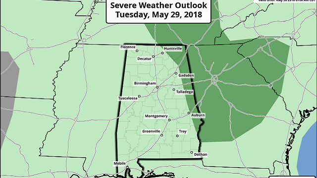
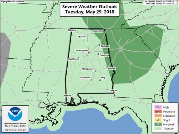
RADAR CHECK: The most widespread rain is over northwest Alabama this afternoon; a flash flood warning is in effect for parts of Colbert, Franklin and Lauderdale counties until 6 p.m.
In the wake of Alberto’s passage, a number of scattered showers and storms are on radar across Alabama, moving northeast. There is still a very low-end threat of an isolated, small tornado over far east Alabama this evening, but so far we have had no issues with rotating showers. We will still watch radar trends closely.
Showers and storms will diminish late tonight as the air becomes more stable.
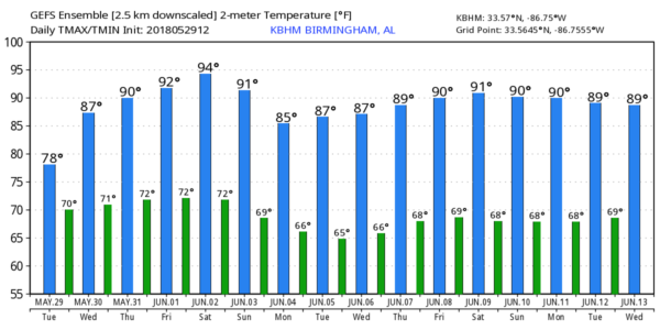
REST OF THE WEEK: Very high precipitable water values will remain over Alabama Wednesday; we expect a mix of sun and clouds with scattered to numerous showers and thunderstorms, mostly during the afternoon hours. The high will be in the mid 80s. Then, the weather trends drier Thursday and Friday. Look for a decent amount of sunshine both days with just a few scattered showers and storms during the peak of the daytime heating process. Heat levels rise, with highs in the 89- to 92-degree range.
THE ALABAMA WEEKEND: Not much change. We should get about seven to nine hours of sunshine Saturday and Sunday with a few scattered, mostly afternoon and evening showers and thunderstorms. The chance of any one spot getting wet both days is about 1 in 3, and we now project highs in the low 90s.
A northerly flow next week should bring highs back down into the 80s; showers and storms for at least the first half of the week will be widely spaced. And there’s no sign of any tropical issues for the Gulf Coast for the next seven to 10 days.
BEACH FORECAST: Click here to see the AlabamaWx Beach Forecast Center page.
WEATHER BRAINS: You can listen to our weekly 90-minute netcast any time on the web, or on iTunes. This is the show all about weather featuring many familiar voices, including meteorologists at ABC 33/40. We will produce this week’s show tonight at 8:30. You can watch it live here.
CONNECT: You can find me on all of the major social networks:
Facebook
Twitter
Google Plus
Pinterest
Snapchat: spannwx
For more weather news and information from James Spann and his team, visit AlabamaWx.


