James Spann: Deeper moisture over west and south Alabama
James Spann forecasts a hot summer work week for Alabama from Alabama NewsCenter on Vimeo.
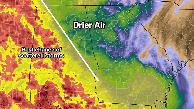
DRIER AIR OVER NORTHEAST ALABAMA: There is a fairly sharp moisture gradient across Alabama today; drier air covered the northeast counties of the state at daybreak. Fort Payne has dropped down to 64 degrees, fairly comfortable for July. Deeper moisture lingers over west and south Alabama, and that is where we expect most of the scattered showers and storms today and early tonight.

The high this afternoon will be close to 90 degrees in most communities.
REST OF THE WEEK: Tomorrow and Wednesday will be partly to mostly sunny, hot and humid. Afternoon showers and storms should be pretty widely spaced; the chance of any one spot getting wet on these two days is in the 10 to 20 percent range. Moisture will be a bit deeper Thursday and Friday, so afternoon storms will be more numerous, but still random and scattered. Afternoon highs tomorrow through Friday will be in the 92- to 95-degree range.
THE ALABAMA WEEKEND: Looks like your classic midsummer weekend — partly sunny, hot and humid Saturday and Sunday with scattered, mostly afternoon and evening showers and thunderstorms. The chance of any one place getting wet will be 30 to 40 percent, and highs should be in the low 90s.
NEXT WEEK: Not much change; we could see an increase in the number of scattered storms toward midweek with the approach of a weak front from the north. Highs will be mostly in the low 90s, right at seasonal averages for mid-July.

TROPICAL STORM CHRIS: The system is basically stationary off the coast of the Carolinas with winds of 60 mph. It could become a hurricane later today; it will finally kick out to the northeast later this week, remaining well off the U.S. East Coast. It will bring rough surf and dangerous rip currents to the middle Atlantic coast over the next few days, however.

BERYL: Tropical Storm Beryl dissipated yesterday; there is some chance of regeneration around the Bahamas in three to five days; if it does get its act together again it will turn northeast and remain east of the U.S. There are no tropical systems threatening the Gulf of Mexico for the next five to seven days.
BEACH FORECAST: Click here to see the AlabamaWx Beach Forecast Center page.
WEATHER BRAINS: You can listen to our weekly 90-minute netcast any time on the web, or on iTunes. This is the show all about weather featuring many familiar voices, including meteorologists at ABC 33/40. We will produce this week’s show tonight at 8:30. You can watch it live here.
CONNECT: You can find me on all of the major social networks:
Facebook
Twitter
Google Plus
Instagram
Pinterest
Snapchat: spannwx
For more weather news and information from James Spann and his team, visit AlabamaWx.