James Spann: Showers, storms fire up today in Alabama
James Spann has the Alabama forecast for muggy Monday from Alabama NewsCenter on Vimeo.
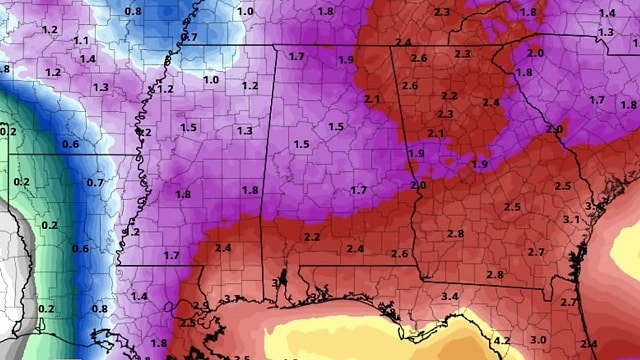
AIR YOU CAN WEAR: Deep moisture continues to cover Alabama today with precipitable water values in excess of 2 inches across much of the state. We note a few rogue showers early this morning over west Alabama, but the bulk of the showers and storms will come this afternoon and early tonight. Like recent days, the storms that form will be rather random, but they will be capable of producing heavy rain, some flooding, gusty winds and lots of lightning. The chance of any one spot getting wet will be in the 60 to 70 percent range, and the high will be between 87 and 91 for most places.
Not much change tomorrow; the sky will be occasionally cloudy with scattered to numerous showers and thunderstorms by afternoon as a surface front approaches from the north.
WEDNESDAY THROUGH FRIDAY: The surface front is expected to drift all the way down into central Alabama by Wednesday morning. This means that drier air will cover the northern half of the state Wednesday and Thursday with few, if any, showers. The chance of showers and storms will continue across the southern counties, however, south of the stalled front. The front will dissipate Friday, and we will mention some risk of showers, but even then they should be pretty widely spaced over the northern counties. Highs will be in the low 90s for most places.
THE ALABAMA WEEKEND: An upper trough will cover the eastern third of the nation, rather anomalous for July. This will put Alabama in a northwest flow pattern; sometimes thunderstorms that originate around St. Louis and Memphis can roll down into the state in this pattern. But aside from that possibility, the air will be fairly dry for summer, so for now we will mention just widely scattered storms Saturday and Sunday with highs around 90 degrees.
NEXT WEEK: Moisture levels rise, and we will cover the week with the usual hot, humid forecast with scattered, mostly afternoon and evening showers and thunderstorms. Highs will be close to 90 most days; we see no sign of any excessive heat (upper 90s or higher) for our state.

TROPICS: Beryl is becoming post-tropical in the North Atlantic; the rest of the Atlantic basin is very quiet. Tropical storm formation is not expected this week.

BEACH FORECAST: Click here to see the AlabamaWx Beach Forecast Center page.
WEATHER BRAINS: You can listen to our weekly 90-minute netcast any time on the web, or on iTunes. This is the show all about weather featuring many familiar voices, including meteorologists at ABC 33/40. We will produce this week’s show tonight at 8:30. You can watch it live here.
CONNECT: You can find me on the major social networks:
Facebook
Twitter
Google Plus
Instagram
Pinterest
Snapchat: spannwx
For more weather news and information from James Spann and his team, visit AlabamaWx.


