James Spann: Unsettled weather for Alabama; eyes on Florence
James Spann has the Alabama forecast to start the work week from Alabama NewsCenter on Vimeo.
WET AT TIMES: A stalled front over far northwest Alabama and an upper trough will set the stage for a good chance of showers and thunderstorms for much of our state today; the sky will be mostly cloudy with a high around 80 degrees. Drier air behind the front is confined to the northwest corner of the state; Muscle Shoals and Florence will see few, if any, showers today.
Scattered to numerous showers and thunderstorms are also likely tomorrow and Wednesday, but then we trend drier Thursday and Friday as we get into the “subsidence ring,” an area of sinking air on the far periphery of Hurricane Florence, which will be near the North Carolina coast. No cool air for the state this week; the high will be close to 90 degrees Thursday and Friday with a decent amount of sun both days.
THE ALABAMA WEEKEND: For now it looks mostly dry; we are forecasting a good supply of sunshine Saturday and Sunday with highs between 87 and 90 degrees. Showers will be very hard to find.
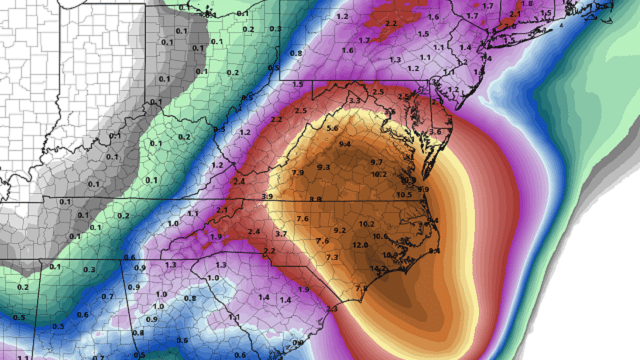
THE LATEST ON FLORENCE: Florence is expected to be a major, dangerous hurricane when it arrives on the U.S. East Coast Thursday night.
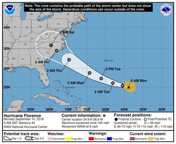
Steering currents are expected to collapse, meaning little motion for a couple of days, and this could lead to severe, life-threatening flooding over parts of the Mid-Atlantic coast region. It is a bit early to forecast specific amounts and placement accurately, but I would imagine some places will easily see more than 2 feet of rain.
ISAAC: Hurricane Isaac is in the Atlantic with 75 mph winds; it will cross the Lesser Antilles later this week and will be in the Caribbean by Friday. Harsh upper winds will affect the system then, and the National Hurricane Center forecasts Isaac to weaken to a tropical storm in four to five days.
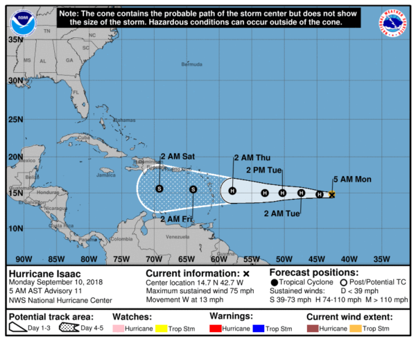
It remains to be seen whether Isaac will enter the Gulf of Mexico; most members of the European model ensemble push the system into central America.
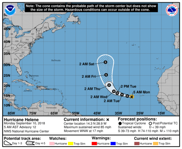
HELENE: In the eastern Atlantic, Hurricane Helene is expected to take a hard right, turning northward into the open water in a few days. No threat to land.
We should mention today is the climatological peak of the hurricane season in the Atlantic basin, so having three hurricanes is not that unusual for this time of the year.
BEACH FORECAST: Click here to see the AlabamaWx Beach Forecast Center page.
WEATHER BRAINS: You can listen to our weekly 90-minute netcast any time on the web, or on iTunes. This is the show all about weather featuring many familiar voices, including meteorologists at ABC 33/40.
CONNECT: You can find me on the major social networks:
Facebook
Twitter
Instagram
Pinterest
Snapchat: spannwx
For more weather news and information from James Spann and his team, visit AlabamaWx.


