James Spann: Wet night ahead for Alabama
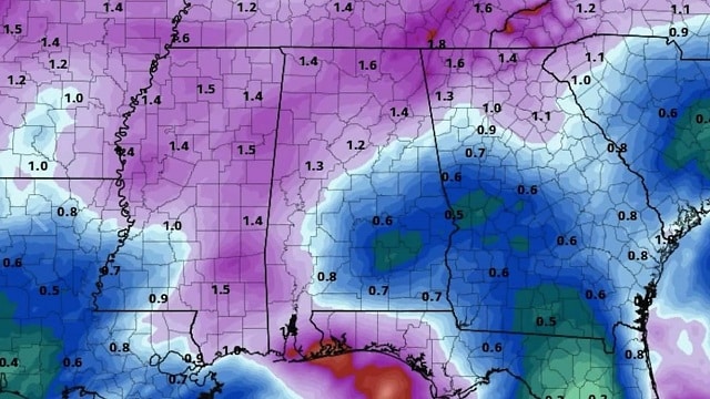
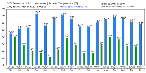
RADAR CHECK: Rain is fairly extensive across Alabama this afternoon in response to a surface low on the Mississippi Gulf Coast. Temperatures are hovering in the 56- to 61-degree range over the northern half of the state because of the clouds and rain; our average high is 73 for Oct. 25 in Birmingham. The wet weather will continue tonight; heavier rain totals will be found over the southern counties of the state, where a few thunderstorms are possible as well. The Storm Prediction Center maintains a marginal risk of severe storms for Mobile and Baldwin counties tonight.

FRIDAY AND THE WEEKEND: Rain will end early Friday, but clouds linger through the day and temperatures remain below average; the high will be in the low 60s for most communities. For Saturday, an upper trough will bring cloudy periods to the state, and maybe just a few isolated showers or patches of light rain during the afternoon and evening — nothing really heavy or widespread, and the high will be in the low 60s again. Sunday should be brighter and warmer; with a partly sunny sky, temperatures rise into the low 70s. A cold front will pass through Sunday night with potential for a few isolated showers, but the air will be pretty dry, and most places won’t see any meaningful rain with that front.
FOOTBALL WEATHER: For the high school games Friday night, the weather will be dry and cool; the sky will be cloudy with temperatures in the 50s.
For Saturday’s Magic City Classic in Birmingham (Alabama State vs. Alabama A&M at Legion Field, with a 2:30 p.m. kickoff), the sky will be occasionally cloudy, and there is just an outside chance of a few light showers during the second half of the game. Temperatures will be in the low 60s at kickoff, but they will fall into the upper 50s by the final whistle.
Alabama and Auburn have a bye week. UAB is on the road, taking on UTEP in El Paso, Texas, Saturday evening (6:30 p.m. kickoff). The sky will be clear, with temperatures falling from the low 70s at kickoff to near 60 by the end of the game.
NEXT WEEK: Monday and Tuesday will be dry; with ample sunshine we expect high in the 60s Monday and 70s Tuesday. Lows will be down in the 40s. Wednesday will be dry during the day, but the latest global models are faster with the next cold front, suggesting a chance of showers late Wednesday night into early Thursday morning — hopefully after the trick or treaters have wrapped up their fun.
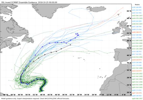
TROPICS: A tropical depression is forming in the central Atlantic; it is expected to become Tropical Storm Oscar in coming days. It will drift westward, but then will be carried out to sea by an upper trough over the eastern U.S.; it is no threat to North America. The rest of the Atlantic basin is quiet.
BEACH FORECAST: Click here to see the AlabamaWx Beach Forecast Center page.
WEATHER BRAINS: You can listen to our weekly 90-minute show any time on your favorite podcast app. This is the show all about weather featuring many familiar voices, including meteorologists at ABC 33/40.
CONNECT: You can find me on all of the major social networks:
Facebook
Twitter
Instagram
Pinterest
Snapchat: spannwx
For more weather news and information from James Spann and his team, visit AlabamaWx.


