James Spann: Rain, storms move into Alabama early Thursday
MILD HALLOWEEN EVENING: Nothing is showing up on radar this afternoon across Alabama; the sky is partly sunny and temperatures are mostly in the upper 70s. Most trick or treaters will have a nice evening, but an approaching storm system will bring active weather to the state early Thursday.
There is an enhanced risk of severe storms through tonight for areas west of Alabama, in the broad area from Houston to Jackson, Mississippi. A few storms are showing tornado potential around Houston.
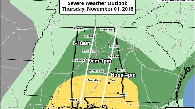
WET/STORMY THURSDAY: A big batch of rain and thunderstorms will move into west Alabama early Thursday and will move steadily eastward. The Storm Prediction Center maintains a slight risk (level 2 out of 5) of severe storms for south Alabama, generally south of U.S. 80, where instability values are higher. There is a marginal risk (level 1 out of 5) for north Alabama:
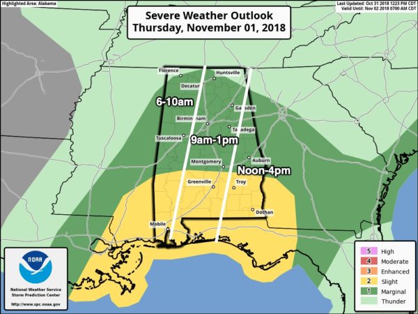
- Most of the rain will come Thursday morning; it will end from west to east early Thursday afternoon.
- Storms over south Alabama in a squall line will be capable of producing strong, perhaps damaging winds, some hail and one or two isolated tornadoes.
- The risk of severe weather for north Alabama is low, but not zero.
- Rain amounts of around 1 inch are likely statewide.
Thursday night will be cloudy with just an outside risk of a little light rain or drizzle.
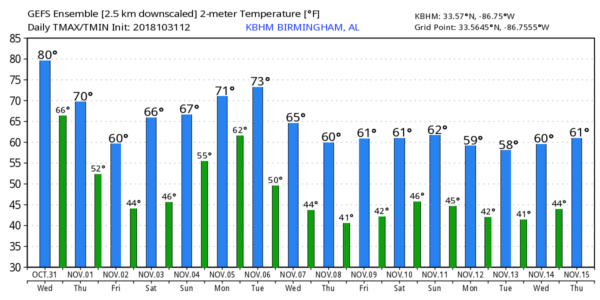
FRIDAY AND THE WEEKEND: Friday will be cloudy and cool, with temperatures holding in the 50s much of the day, and again there could be a bit of light drizzle, mainly during the morning. The sky will clear Friday night and the weekend looks delightful, with ample sunshine Saturday and Sunday. The high Saturday will be in the mid to upper 60s, and Sunday’s high will be close to 70 degrees. Saturday morning will be cold, with lows between 38 and 42 for most communities; colder pockets will see some frost.
FOOTBALL WEATHER: We’ll have great weather for the high school games across the state Friday night; look for a clearing sky with temperatures falling from the mid 50s at kickoff into the 40s by the fourth quarter.
Auburn will host Texas A&M Saturday (11 a.m. kickoff) at Jordan-Hare Stadium. The sky will be sunny, with temperatures rising from near 64 degrees at kickoff into the upper 60s by the second half.
Alabama is on the road to take on LSU in Baton Rouge Saturday night (7 p.m. kickoff). It will be a perfect night for football, with a clear sky and temperatures falling through the 60s.
UAB will host UTSA at Legion Field in Birmingham Saturday evening (6:30 p.m. kickoff). The sky will be clear with low 60s at kickoff and mid 50s by the fourth quarter.
NEXT WEEK: Moist air returns Monday with a chance of showers and possibly a thunderstorm. And we are still seeing signals from global models that strong to severe storms will be a threat to Alabama and the Deep South on Tuesday, Election Day. It’s way too early for details, of course; just something to watch for now. The rest of the week looks cool and dry.
TROPICS: Oscar is becoming post-tropical in the North Atlantic. The rest of the Atlantic basin is quiet.
BEACH FORECAST: Click here to see the AlabamaWx Beach Forecast Center page.
WEATHER BRAINS: You can listen to our weekly 90-minute show any time on your favorite podcast app. This is the show all about weather featuring many familiar voices, including meteorologists at ABC 33/40.
CONNECT: You can find me on all of the major social networks:
Facebook
Twitter
Instagram
Pinterest
Snapchat: spannwx
For more weather news and information from James Spann and his team, visit AlabamaWx.


