James Spann: Alabama stays cloudy through Friday, with rain at times
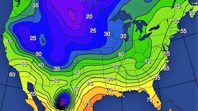
RADAR CHECK: A large mass of rain and thunderstorms is pushing out of Alabama this afternoon; most communities picked up around 1 inch. We had a report of 1.61 inches at Lafayette in Chambers County. In addition to the rain we have a big thermal contrast across the state thanks to a stalled front over south Alabama. Dothan and Mobile are in the low 80s, but north of the front temperatures are in the 50s over the northern counties of the state.
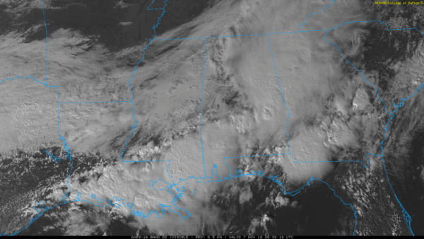
Clouds will hang tough across Alabama Thursday with a few periods of rain. On Friday, rain is likely mainly during the morning as a cold front rolls through the state. Temperatures should begin to fall Friday afternoon in the wake of the front. We start the day in the 50s Friday morning, but we drop into the 40s Friday afternoon with a brisk north wind. The sky will clear Friday night.
THE ALABAMA WEEKEND: Mornings will be cold; we project a low between 30 and 35 both Saturday and Sunday mornings, with 20s for the colder valleys. Widespread frost is likely early Sunday, when the wind will be near calm. The sky will be sunny Saturday with a high in the low 50s; clouds increase Sunday with a high in the mid to upper 50s.
FOOTBALL WEATHER: For the high school games Friday night, we expect a clearing sky with temperatures falling through the 40s.
Saturday, Alabama hosts Mississippi State at Bryant-Denny Stadium (2:30 p.m. kickoff). The sky will be sunny with a kickoff temperature near 53 degrees, falling into the 40s by the fourth quarter.
Auburn is at Georgia Saturday (6 p.m. kickoff). The sky will be clear with temperatures falling from near 50 at kickoff into the low 40s by the final whistle.
UAB will host Southern Miss at Legion Field Saturday evening (6:30 p.m. kickoff). The sky will be clear with temperatures falling through the 40s.
NEXT WEEK: A cold rain is likely Monday with temperatures struggling to get out of the 40s; that rain will end early Tuesday. But Tuesday will be a windy, raw, mostly cloudy day with a high only in the low to mid 40s; it will feel colder with a brisk north wind of 12 to 25 mph. Then, Wednesday morning will feature a low down in the mid 20s, right at record levels for Nov. 14. The record low at Birmingham on Nov. 14 is 24, set in 1986. The day Wednesday will be sunny with a high in the mid 50s.
The rest of the week will be dry with a slow warming trend.

BEACH FORECAST: Click here to see the AlabamaWx Beach Forecast Center page.
WEATHER BRAINS: You can listen to our weekly 90-minute show any time on your favorite podcast app. This is the show all about weather featuring many familiar voices, including meteorologists at ABC 33/40.
CONNECT: You can find me on all of the major social networks:
Facebook
Twitter
Instagram
Pinterest
Snapchat: spannwx
For more news and information from James Spann and his team, visit AlabamaWx.


