James Spann: Windy, much colder in Alabama today
James Spann has the Alabama forecast heading toward the weekend from Alabama NewsCenter on Vimeo.
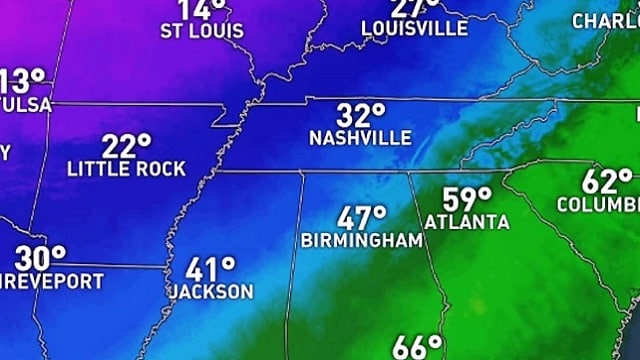
WINDS OF CHANGE: A few spots soared into the low 80s across Alabama yesterday; today will be a different kind of day following a cold front that passed through late last night. It will be much colder with a brisk northwest wind of 12-22 mph; lingering light rain early this morning will end, and the sky becomes partly sunny. Communities across the northern half of the state won’t get out of the 40s; for many places, today will be 30 to 35 degrees colder than yesterday.
Tonight will be mostly fair and cold with diminishing wind; we project a low between 25 and 29 degrees early Saturday morning across north and central Alabama.
THE ALABAMA WEEKEND: Saturday will be cool and dry; with a mix of sun and clouds we project an afternoon high in the 50- to 55-degree range. Sunday will be a mostly cloudy day, and we will bring in the chance of a few rain showers as a warm front over south Alabama begins to move slowly northward. Sunday’s high will be close to 50 degrees, but 60s are likely over the southern counties of the state, below the warm front.
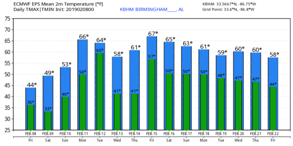
NEXT WEEK: Monday will be warmer with highs in the 60s statewide, and a few scattered showers are possible. Then, rain and a few thunderstorms are likely on Tuesday with the approach of a cold front; the weather will stay mild with temperatures in the 60s. Wednesday and Thursday look cool and dry, but rain will likely return by Thursday night into Friday morning. There’s no sign of any excessively cold air, snow, ice, severe storms or flooding for Alabama over the next seven to 10 days.
YESTERDAY’S WARMTH: Almost all major reporting stations in Alabama reported new daily record highs yesterday. Here are some of the maximum temperatures:
- Tuscaloosa — 82
- Millport — 82
- Montgomery — 81
- Coker — 81
- Jacksonville — 81
- Anniston — 80
- Auburn — 80
- Dothan — 80
- Birmingham — 79
- Northport — 79
- Mobile — 79
- Calera — 78
- Jemison — 78
- Rainbow City — 77
ON THIS DATE IN 2013: A nor’easter produced heavy snowfall over the New England states. Total snowfall in Boston, Massachusetts, reached 24.9 inches, the fifth-highest total ever recorded in the city. New York City officially recorded 11.4 inches of snow at Central Park, and Portland, Maine, set a record of 31.9 inches. Hamden, Connecticut, recorded the highest snowfall of the storm at 40 inches. Many surrounding cities picked up at least 1 foot. In addition to the significant snowfall totals, hurricane-force wind gusts were recorded, reaching 102 mph in Nova Scotia, 89 mph at Mount Desert Rock, Maine, and 84 mph off the coast of Cuttyhunk, Massachusetts.
BEACH FORECAST: Click here to see the AlabamaWx Beach Forecast Center page.
WEATHER BRAINS: You can listen to our weekly 90-minute show any time on your favorite podcast app. This is the show all about weather featuring many familiar voices, including the meteorologists at ABC 33/40.
CONNECT: You can find me on all of the major social networks:
Facebook
Twitter
Instagram
Pinterest
Snapchat: spannwx
For more weather news and information from James Spann and his team, visit AlabamaWx.


