James Spann: Severe storms possible in Alabama late Saturday
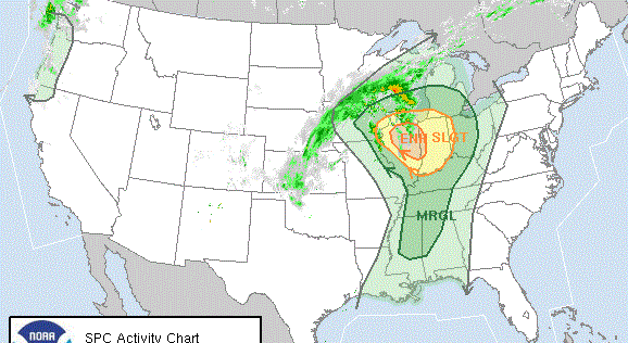
RADAR CHECK: The most widespread rain at mid-afternoon is over northwest Alabama; a number of aerial flood warnings and advisories have been issued there. Showers are more scattered in nature over the rest of the state. There is a huge thermal contrast; at mid-afternoon Montgomery soared to 81 degrees south of a warm front, but to the north Haleyville was 36 degrees colder at 45.

Occasional showers and a few thunderstorms will continue through Friday across the state, with the most widespread rain over the Tennessee Valley. The Weather Prediction Center has put far north Alabama in a high risk of flooding Friday, with additional rain amounts of 3-4 inches expected over the next 36 hours.

Friday will be warmer, with a high in the 70s for most of the state; a few spots across south Alabama will reach the low 80s again.
SEVERE STORMS POSSIBLE LATE SATURDAY/SATURDAY NIGHT: Saturday will be a warm and windy day with scattered showers possible; temperatures will rise into the mid 70s, maybe even the upper 70s in spots, by afternoon. An approaching cold front supported by a strong upper trough will bring the risk of severe storms to the state by late afternoon and into Saturday night.
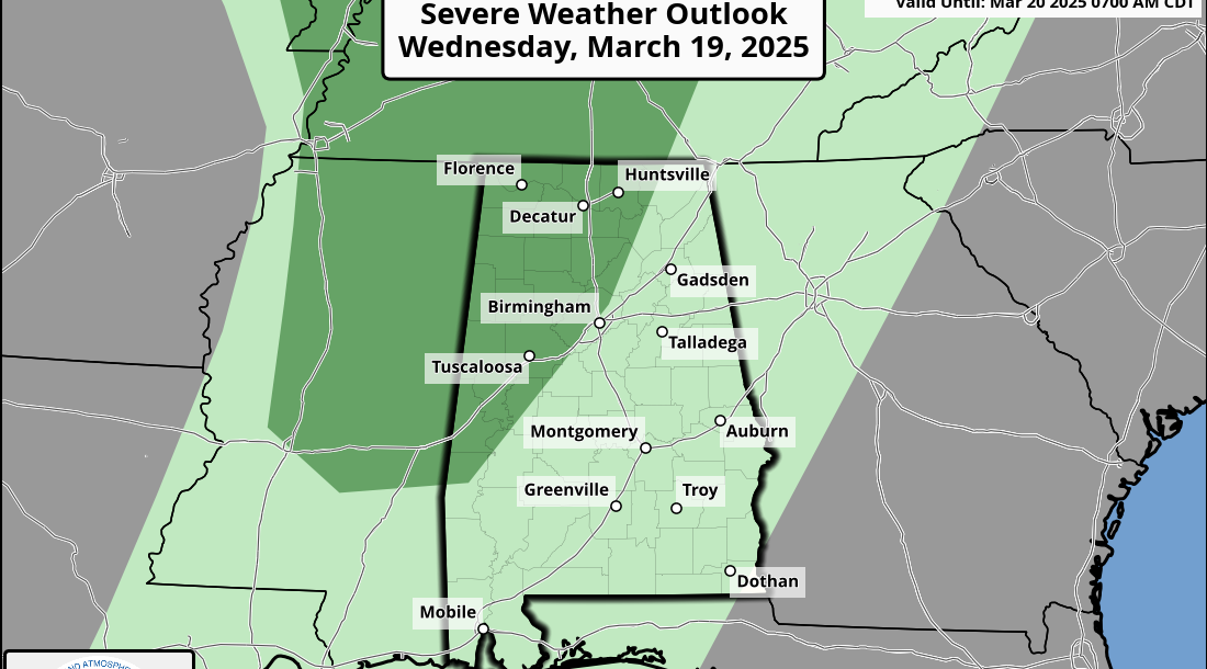
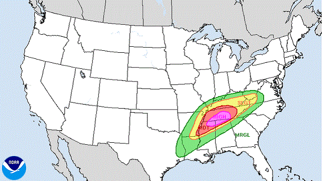
The Storm Prediction Center has defined an enhanced risk (level 3 out of 5) for the northwest tip of the state, with a slight risk (level 2 of 5) down to Linden, Calera, Talladega and Centre. A marginal risk (level 1 of 5) extends as far south as Mobile, Montgomery and Roanoke.

TIMING: The main window for severe storms in Alabama will come from roughly 4 p.m. until midnight. Initially the threat will be over the northwest part of the state, then will shift southward during the night. Storms should weaken to below severe limits after midnight as they move into the southeast part of the state.
THREATS: The core threat will come from damaging straight-line winds within the squall line ahead of the front, but hail and a few isolated tornadoes are possible as well. Strong pressure gradient winds out of the south averaging 12-25 mph with higher gusts could bring down a few trees thanks to the very soggy ground soil.
FLOODING: With the ground saturated, any additional rain could produce some flooding across the northern half of the state.
Be sure you have a way of hearing severe weather watches and warnings this weekend.
Drier air returns to the state Sunday with a clearing sky, along with a high in the 60s.
NEXT WEEK: The weather stays dry Monday and Tuesday, but rain returns to the state Wednesday. Then, Thursday and Friday look rain-free. Highs next week will be mostly in the 60s.

RAIN STATS: Birmingham has measured 20.67 inches of rain since Dec. 1, 8.2 inches above average. The city has received measurable rain on 37 of the 83 days since Dec. 1 (45 percent).
BEACH FORECAST: Click here to see the AlabamaWx Beach Forecast Center page.
WEATHER BRAINS: You can listen to our weekly 90-minute show any time on your favorite podcast app. This is the show all about weather featuring many familiar voices, including the meteorologists at ABC 33/40.
CONNECT: You can find me on all of the major social networks:
Facebook
Twitter
Instagram
Pinterest
Snapchat: spannwx
For more weather news and information from James Spann and his team, visit AlabamaWx.