James Spann: Strong to severe storms still possible in Alabama tonight
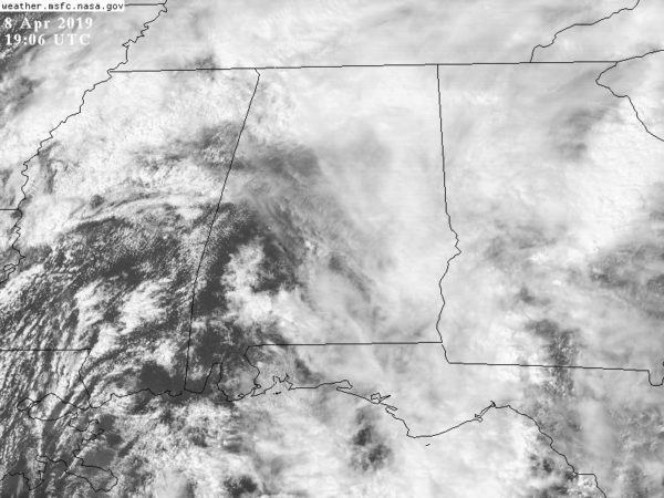
EYES ON THE RADAR: No severe storms are in progress across Alabama at mid-afternoon; there is a large mass of rain over the Tennessee Valley, and the rest of the state is mostly dry with only isolated showers. There are some big breaks in the cloud cover over west and southwest Alabama, where temperatures are approaching 80 degrees. This is one area to watch this evening for new thunderstorm development since the air there is becoming quite unstable.
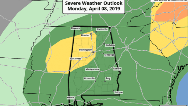
The Storm Prediction Center maintains a slight risk (level 2 out of 5) of severe thunderstorms for parts of north and west Alabama overnight, with a marginal risk (level 1 of 5) for the rest of the state.
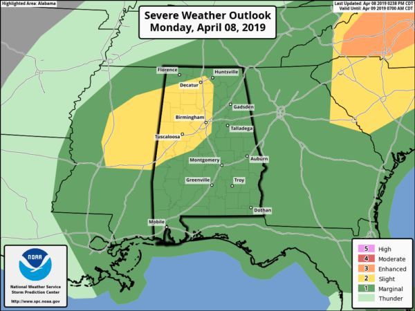
Additional showers and thunderstorms are expected to develop overnight across Alabama, with the primary threats coming from hail and gusty straight-line winds. There is only a low-end tornado threat across the state tonight. Strong storms are possible any time from now through 6 a.m. Tuesday.
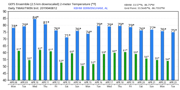
Lingering showers will end by midday Tuesday, and we should see some clearing by mid to late afternoon. The weather will be mild, with a high in the mid to upper 70s.
WEDNESDAY THROUGH FRIDAY: Wednesday and Thursday will be warm and dry with highs in the 80- to 84-degree range; expect a good supply of sunshine both days. Then, a cold front will bring some risk of showers, and possibly a thunderstorm late Thursday night or early Friday, but with limited moisture and instability we aren’t expecting any severe storms for now. Some sun could break through Friday afternoon.
PALM SUNDAY WEEKEND: A wave of low pressure is expected to bring a fairly large mass of rain into Alabama at some point during the day Saturday, continuing Saturday night. On Sunday, a deep surface low is expected to be just northwest of here, and that could very well set the stage for strong to severe thunderstorms on Palm Sunday for much of the state. We are six days out, and this could change, of course. We will be able to provide more details on the active weekend weather situation later this week. The high Saturday and Sunday will be in the 70s.
STORM SURVEYS: National Weather Service survey teams have identified two EF-1 tornado tracks from early this morning (the result of the same parent thunderstorm). One was in northern Blount County (the path length was 6.3 miles), and the other was in Marshall County. More details will follow as survey work continues.
ON THIS DATE IN 1998: A powerful EF-5 tornado tore through the western suburbs of Birmingham, impacting communities like Oak Grove, Rock Creek, Sylvan Springs, McDonald Chapel and Pratt City. The death toll was 32 in Jefferson County, with more than 250 injuries. More than 1,000 homes were destroyed and more than 900 homes sustained significant damage. The same parent thunderstorm dropped another tornado in St. Clair County (rated EF-2) that killed two people north of Pell City at Wattsville.
BEACH FORECAST: Click here to see the AlabamaWx Beach Forecast Center page.
WEATHER BRAINS: You can listen to our weekly 90-minute show any time on your favorite podcast app. This is the show all about weather featuring many familiar voices, including the meteorologists at ABC 33/40.
CONNECT: You can find me on all of the major social networks:
Facebook
Twitter
Instagram
Pinterest
Snapchat: spannwx
For more weather news and information from James Spann and his team, visit AlabamaWx.


