James Spann: Lingering showers in Alabama this morning
James Spann has the Alabama forecast for Tuesday and a look ahead to a stormy weekend from Alabama NewsCenter on Vimeo.
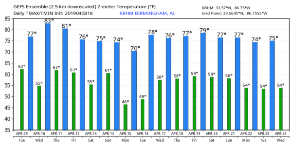
RADAR CHECK: Lingering showers continue across parts of central Alabama this morning as an upper trough moves through the state. Most of the rain should be over by midday, but a few stray afternoon showers aren’t out of the question. Otherwise, today will be cloudy and mild, with a high in the mid to upper 70s.
WEDNESDAY/THURSDAY/FRIDAY: It looks like Wednesday will be the warmest day so far this year. Many communities will reach the mid 80s with a good supply of sunshine. Thursday will be partly sunny with a high in the low 80s. Clouds will increase tomorrow night, and a band of showers will likely pass through the state Friday morning ahead of a cold front. Moisture will be limited, and we don’t expect any issue with severe thunderstorms. Friday’s high will be close to 80 degrees with a mostly cloudy sky.
STORMY WEEKEND: The front will lift northward as a warm front Saturday, and we will need to mention some risk of rain during the day. It won’t rain all day, however, and the sun could even break out at times, especially over south Alabama. There’s no way of knowing right now when the best chance of rain will be on Saturday; we can be more specific as we get closer to the weekend. The high will be near 80 degrees.
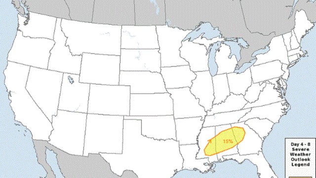
A robust weather system will bring the risk of strong to severe thunderstorms to the state late Saturday night into Palm Sunday; the Storm Prediction Center has defined a risk of severe storms for central Alabama.
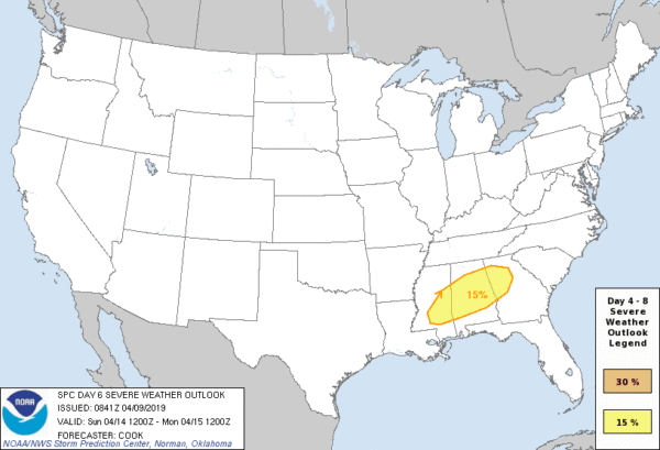
Again, it is too early to be specific, but there could be a significant risk of severe thunderstorms Sunday, with all modes of severe weather possible, including a few tornadoes. Churches will need to be sure they have a way of hearing watches and warnings if they are needed (NOAA Weather Radio), and have a plan to put everyone in a safe place.
NEXT WEEK: The first half of next week will be dry and cooler; early morning lows will likely drop into the 40s Monday and Tuesday.
ON THIS DATE IN 1953: The first radar image of a tornado was detected by radar equipment at the University of Illinois Airport at Champaign, Illinois. Studies of the radar pictures from that day showed that a tornado of significant size and intensity could be detected.
BEACH FORECAST: Click here to see the AlabamaWx Beach Forecast Center page.
WEATHER BRAINS: You can listen to our weekly 90-minute show any time on your favorite podcast app. This is the show all about weather featuring many familiar voices, including the meteorologists at ABC 33/40.
CONNECT: You can find me on all of the major social networks:
Facebook
Twitter
Instagram
Pinterest
Snapchat: spannwx
For more weather news and information from James Spann and his team, visit AlabamaWx.


