James Spann: Unsettled weather continues for Alabama today
James Spann has the Tuesday forecast for Alabama and the latest on Tropical Storm Dorian from Alabama NewsCenter on Vimeo.
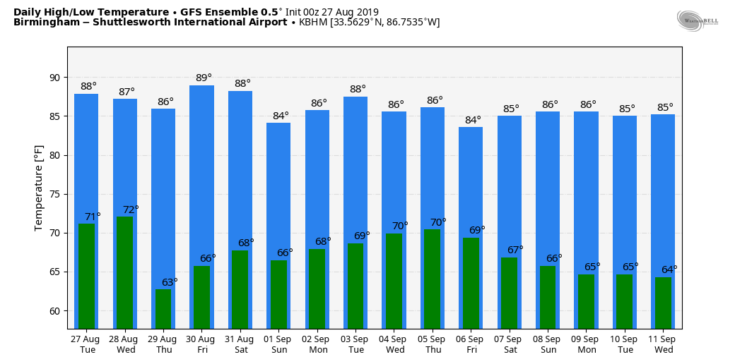
WET AT TIMES: We are forecasting scattered to numerous showers and thunderstorms across Alabama today as a very moist air mass remains in place and a surface front approaches. We do expect some sun today, and it will be warmer, with a high back in the mid 80s for most communities.
WEDNESDAY THROUGH FRIDAY: Drier air moves into north Alabama late tonight, and on Wednesday any showers should be confined to the southern half of the state. Thursday and Friday will be rain-free with sunny days, lower humidity and cooler nights. Afternoon highs will range from 87 to 90, but some of the cooler spots across north and central Alabama could reach the 50s early Thursday morning.
LABOR DAY WEEKEND: Models have trended drier for Saturday and we will mention only isolated afternoon showers with a partly to mostly sunny sky; the high will be around 90. Then, we will bring in the chance of scattered showers and thunderstorms Sunday and Monday as moisture levels rise. The weather on Labor Day will greatly depend on how Tropical Storm Dorian behaves, so there is considerable uncertainty in the forecast.
That can be said for the middle of next week as well; our weather will be dependent on the track and intensity of Tropical Storm Dorian.
 FOOTBALL WEATHER: UAB will host Alabama State Thursday night at Birmingham’s Legion Field; the kickoff is at 7. The weather will be delightful — a clear sky with temperatures falling from near 85 at kickoff into the 70s during the second half.
Alabama will take on Duke in the Chick-fil-A Kickoff Classic in Atlanta (2:30 p.m. Central kickoff). The game will be played indoors at Mercedes-Benz Stadium, but outside the sky will be mostly sunny with only isolated showers. Temperatures will peak close to 90 in Atlanta Saturday afternoon.
Auburn travels to Dallas/Fort Worth to take on Oregon at AT&T Stadium Saturday evening (7:30 Central kickoff). Temperatures will top out in the mid 90s during the day Saturday with a sunny sky, falling though the 80s during the game.
TD 6: Tropical Depression Six is forecast to become Tropical Storm Erin by tonight; this is in the Atlantic well east of the U.S. coast. It will move toward the Canadian maritimes and become post-tropical by the end of the week.
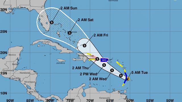
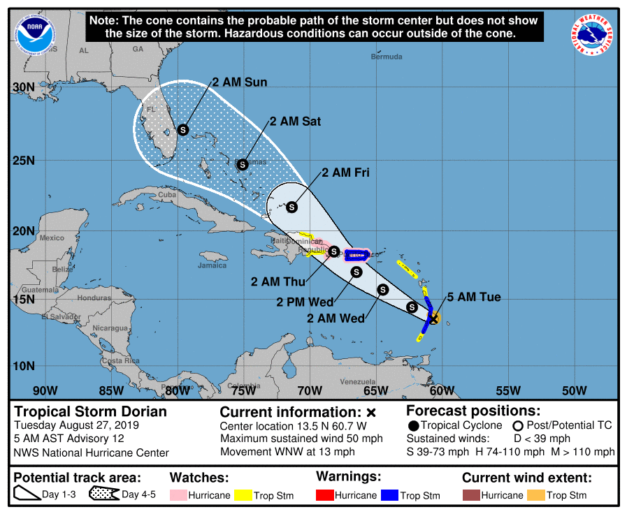
DORIAN: Tropical Storm Dorian is moving through the Windward Islands this morning with sustained winds of 50 mph. The National Hurricane Center now keeps the system under hurricane strength in its forecast through Saturday. The circulation center is forecast to pass south of Puerto Rico Wednesday, then clip the eastern tip of Hispaniola late Wednesday night. From there, it moves through the Bahamas, winding up near West Palm Beach, Florida, late Saturday night.
Some important points:
- The average five-day track error is around 200 miles, so the NHC forecast can and probably will change.
- There remains considerable uncertainty for the part of the forecast beyond 36 hours because the future intensity of Dorian will be quite dependent on how much land interaction there is with the mountainous island of Hispaniola.
- While uncertainty remains high, wind and rain impacts are possible in the Bahamas and the Florida Peninsula later this week and this weekend. Residents in these areas should monitor the progress of Dorian and ensure that they have their hurricane plan in place.
- Impact on Alabama and the Gulf Coast, if any, is simply not known this far in advance. If you have a trip to a place like Panama City Beach, Destin or Gulf Shores for Labor Day, there’s no need to change plans, but watch for updates through the week.
The rest of the Atlantic basin is quiet.
ON THIS DATE IN 1883: Krakatoa Volcano exploded in the East Indies. The explosion was heard more than 2,500 miles away, and every barograph around the world recorded the passage of the airwave, up to seven times. Giant waves, 125 feet high and traveling 300 mph, devastated everything in their path, hurling ashore coral blocks weighing up to 900 tons, and killing more than 36,000 people. Volcanic ash was carried around the globe in 13 days, producing blue and green suns in the tropics and vivid red sunsets in higher latitudes. The temperature of the earth was lowered one degree for the next two years, finally recovering to normal by 1888.
BEACH FORECAST: Click here to see the AlabamaWx Beach Forecast Center page.
WEATHER BRAINS: You can listen to our weekly 90-minute show any time on your favorite podcast app. This is the show all about weather featuring many familiar voices, including the meteorologists at ABC 33/40.
CONNECT: You can find me on all of the major social networks:
Facebook
Twitter
Instagram
Pinterest
Snapchat: spannwx
For more weather news and information from James Spann and his team, visit AlabamaWx.


