James Spann: Dry weather for Alabama through the weekend
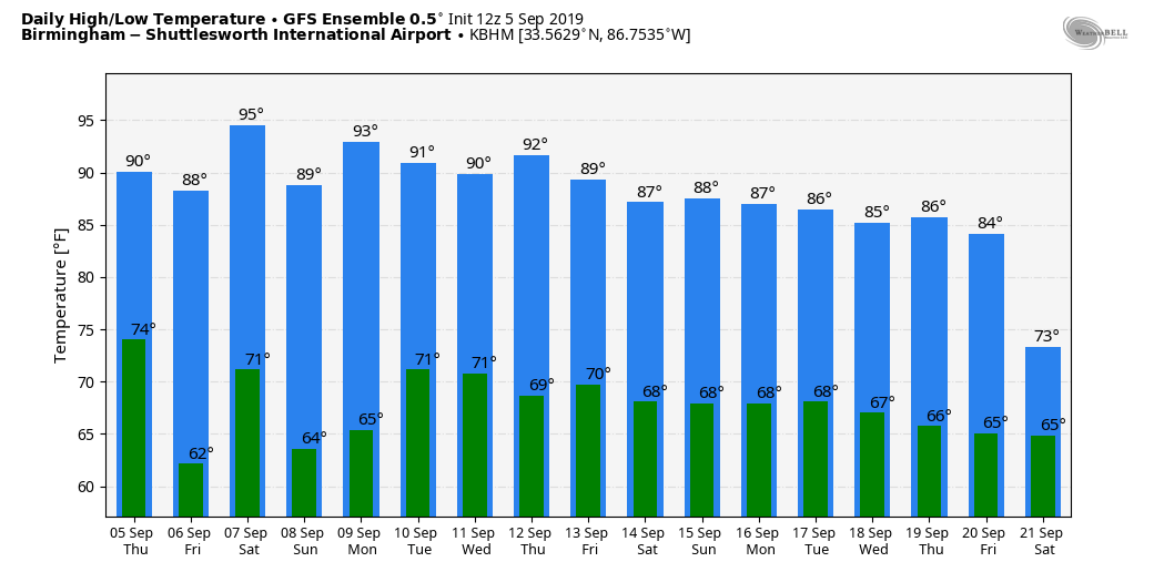
SUNNY, BREEZY AFTERNOON: Temperatures are generally in the upper 80s and low 90s the afternoon; the average high for Sept. 5 at Birmingham is 88. No, it doesn’t magically get cool after Labor Day in Alabama. On this date in 1925 it was 112 degrees at Centreville, the hottest temperature on record in our state. The mean last day of 90-degree heat (based on data at Birmingham) is Sept. 19, but we have experienced 90-degree heat as late as Oct. 20.
The sky is sunny, and tonight will be clear and pleasant. Some of the cooler spots could dip into the upper 50s early Friday morning. Then, during the day Friday the sky will be sunny with a high in the low 90s.
THE ALABAMA WEEKEND AND NEXT WEEK: Sunny weather continues Saturday and Sunday; we project highs over the weekend in the 93- to 97-degree range, and lows will be in the 60s for most communities. Not much change is expected Monday, but we will bring in a chance of widely scattered showers Tuesday and Wednesday as moisture levels begin to rise — not really beneficial rain, but some spots could see a shower or two.
FOOTBALL WEATHER: For the high school games Friday night, the sky will be clear with temperatures falling from the upper 80s at kickoff into the upper 70s by the final whistle.
On Saturday, Alabama hosts New Mexico State at Bryant-Denny Stadium in Tuscaloosa (3 p.m. kickoff). It will be a sizzling afternoon with a kickoff temperature near 97 degrees, falling into the low 90s by the fourth quarter. The sky will be mostly sunny.
Auburn will host Tulane Saturday evening (6:30 kickoff). The sky will be clear with temperatures falling from 90 degrees at kickoff into the upper 70s by the final whistle.
UAB is on the road, traveling to Akron, Ohio, to play the Zips Saturday (11 a.m. Central kickoff). The sky will be mostly sunny with temperatures rising from near 70 at kickoff into the mid 70s by the fourth quarter.
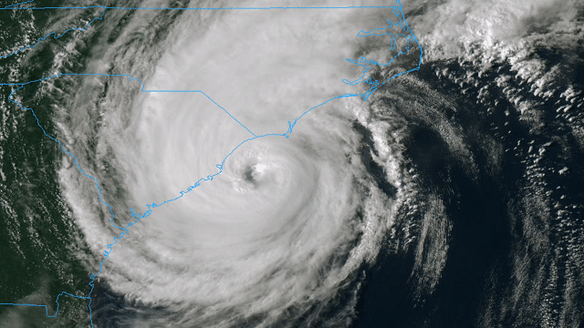
HURRICANE DORIAN: Dorian now features maximum sustained winds of 110 mph, a Category 2 on the Saffir-Simpson scale. The hurricane is moving north/northeast at 8 mph, and the center is 60 miles south of Myrtle Beach at mid-afternoon.

Important points:
- Life-threatening storm surge and dangerous winds are expected along portions the coasts of South Carolina and North Carolina, and portions of southeast Virginia and the southern Chesapeake Bay, regardless of the exact track of Dorian’s center. Water levels could rise well in advance of the arrival of strong winds. Residents in these areas should follow advice given by local emergency officials.
- The hurricane is now moving into the mid-latitude westerlies, and during the next several hours it is expected to turn northeastward with an increase in forward speed. This should bring the eye near or over the coasts of eastern South Carolina and southeastern North Carolina during the next 12-24 hours. After that, Dorian is forecast to move quickly across the northwest Atlantic and be near or over the Canadian Maritimes/Atlantic provinces by 72 hours.
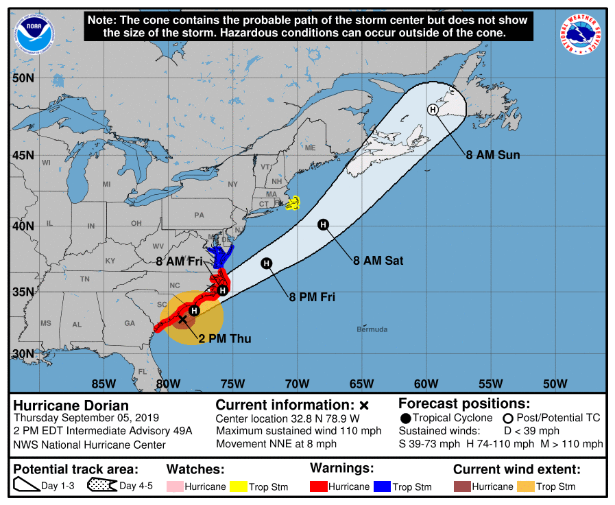
- Dorian is forecast to slowly weaken as it moves along the South Carolina and North Carolina coasts. Extratropical transition should begin in around 48 hours and be complete by 72 hours, although Dorian is forecast to maintain hurricane-force winds through the transition. After 72 hours, the extratropical low should weaken over the far North Atlantic.
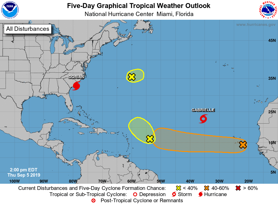
TROPICAL STORM GABRIELLE: This system is in the eastern Atlantic and is gaining latitude. It is no threat to land.
ELSEWHERE IN THE TROPICS: Tropical waves are northeast of Bermuda and east of the Leeward Islands; these are not expected to develop. A well-organized wave near the Cape Verde Islands has potential for development over the next five days as it moves west/northwest. It’s too early to know if this will be a threat to the Lesser Antilles or the U.S.
ON THIS DATE IN 1925: The state recorded its hottest temperature ever, 112 degrees, at Centreville. It was 108 in Gadsden and 109 in Demopolis. It was 105 in Tuscaloosa and 104 in Cullman. Every reporting station in Alabama recorded a high of 100 degrees or higher on this date, an unprecedented event that has never been repeated.
BEACH FORECAST: Click here to see the AlabamaWx Beach Forecast Center page.
WEATHER BRAINS: You can listen to our weekly 90-minute show any time on your favorite podcast app. This is the show all about weather featuring many familiar voices, including the meteorologists at ABC 33/40.
CONNECT: You can find me on the major social networks:
Facebook
Twitter
Instagram
Pinterest
Snapchat: spannwx
For more weather news and information from James Spann and his team, visit AlabamaWx.