James Spann: Heat stays on Alabama through Wednesday, then eases off a bit
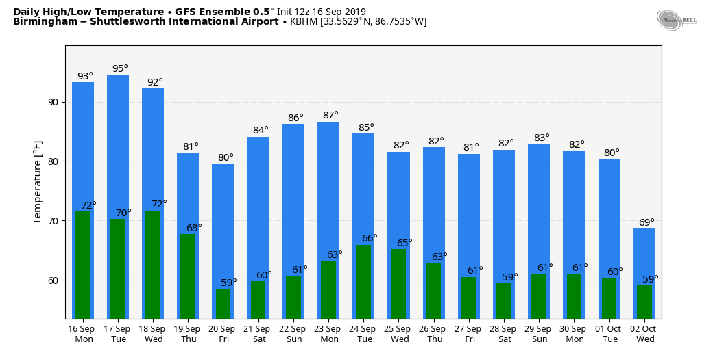
HOT AFTERNOON: Temperatures are generally in the mid 90s across Alabama this afternoon, but a few have wandered into the upper 90s, not far from record levels. The hottest so far for Birmingham (as of 3 p.m.) today is 97, four degrees shy of the record high for Sept. 16 — 101, set in 1927.
REST OF THE WEEK: The weather won’t change much Tuesday and Wednesday; it will be hot and dry with a good supply of sunshine both days. Highs will be well up into the 90s, a good 10 degrees above average for mid-September in Alabama. Then, a “backdoor” cold front will push through the state Wednesday night. This will drop temperatures about 10-12 degrees by Thursday and Friday. Highs will be in the mid to upper 80s on those two days, with lows well down in the 60s.
Unfortunately, we really don’t see much chance of meaningful rain this week; a few sprinkles or showers are possible along the front Wednesday evening, but most places will stay dry. Drought conditions will intensify over east Alabama and develop over west Alabama.
THE ALABAMA WEEKEND: Dry weather continues; look for a good supply of sunshine Saturday and Sunday with afternoon highs generally between 87 and 90. Lows will be in the 60s.
NEXT WEEK: A surface front will drift down toward the Alabama-Tennessee border Monday and could produce a few showers over the northern part of the state, but for now it looks like moisture will be pretty limited and rain amounts, if any, should be light.
As you look at model output statistics like those posted below, you will need to add about five degrees to the forecast afternoon highs because of the lack of soil moisture.
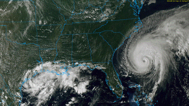
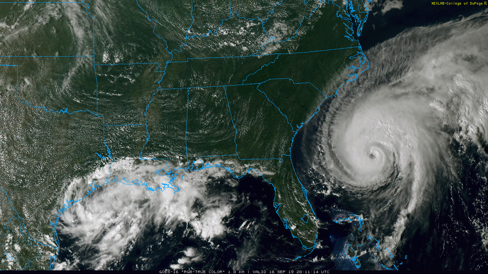
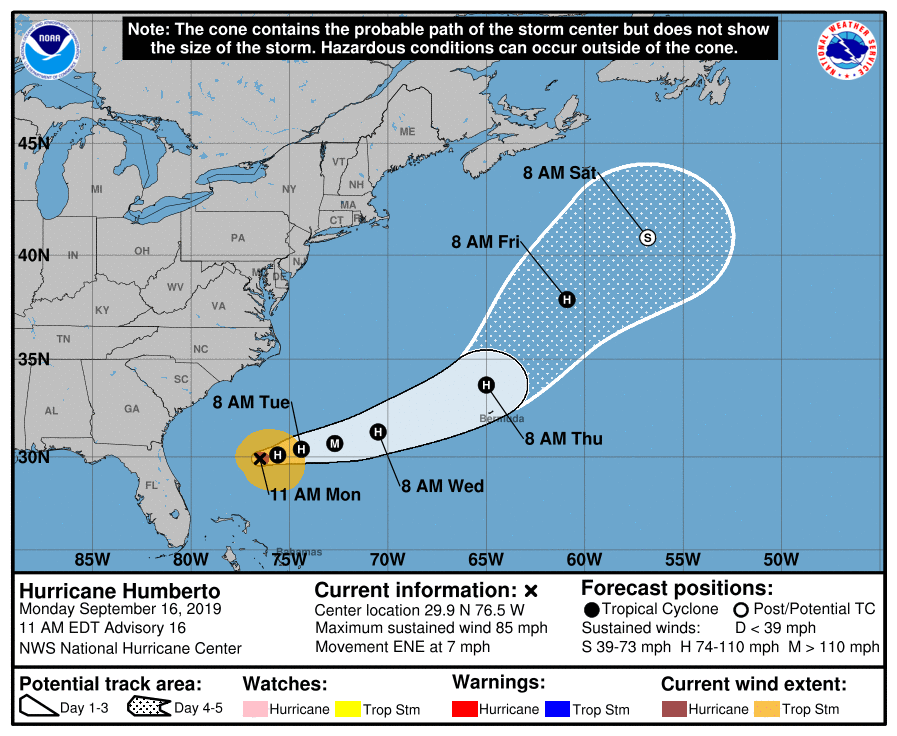
TROPICS: Hurricane Humberto is packing sustained winds of 85 mph this afternoon and is forecast to briefly become a major Category 3 hurricane Tuesday as it moves away from the U.S. in the Atlantic. It is forecast to pass just north of Bermuda Thursday morning before becoming post-tropical over the North Atlantic during the weekend.
ELSEWHERE: A disturbance in the western Gulf of Mexico will move into Texas Tuesday with just a low chance of development before it moves inland. A tropical wave in the Atlantic has a high chance of development over the next few days, but it will move north and recurve harmlessly without getting close to the U.S. later this week.
ON THIS DATE IN 2004: At 51 minutes after midnight on Sept. 16, the northern eyewall of powerful Hurricane Ivan moved onto land near Gulf Shores as an upper Category 3 hurricane, bringing with it 130 mph surface winds and a historic storm surge. Preliminary estimates show that the magnitude and extent of the damage and destruction over Baldwin County and Escambia and Santa Rosa counties of northwest Florida likely exceeded that of both Hurricane Frederic (September 1979) and Hurricane Opal (October 1995). Hurricane Ivan was very close to the magnitude of damage and destruction caused by the Hurricane of 1926, which ravaged the aforementioned counties east of Mobile Bay. Hurricane Ivan caused a preliminary total of 13 deaths in Baldwin County, Alabama; Escambia County, Florida, and Santa Rosa County, Florida. Damage was more than $5 billion.
Ivan produced estimated maximum winds of 60 to 80 mph generally southwest of a line from Prattville to Livingston. A few spots may have reached 90 mph in this area. Most other locations across central alabama had estimated maximum wind speeds of 50 to 60 mph, with a few isolated spots reaching 75 mph. Damage was severe well inland; some of the hardest-hit communities were Atmore, Brewton, Evergreen, Monroeville, Camden and Demopolis.
BEACH FORECAST: Click here to see the AlabamaWx Beach Forecast Center page.
WEATHER BRAINS: You can listen to our weekly 90-minute show any time on your favorite podcast app. This is the show all about weather featuring many familiar voices, including the meteorologists at ABC 33/40.
CONNECT: You can find me on the major social networks:
Facebook
Twitter
Instagram
Pinterest
Snapchat: spannwx
For more weather news and information from James Spann and his team, visit AlabamaWx.