James Spann: A few isolated showers for Alabama this afternoon
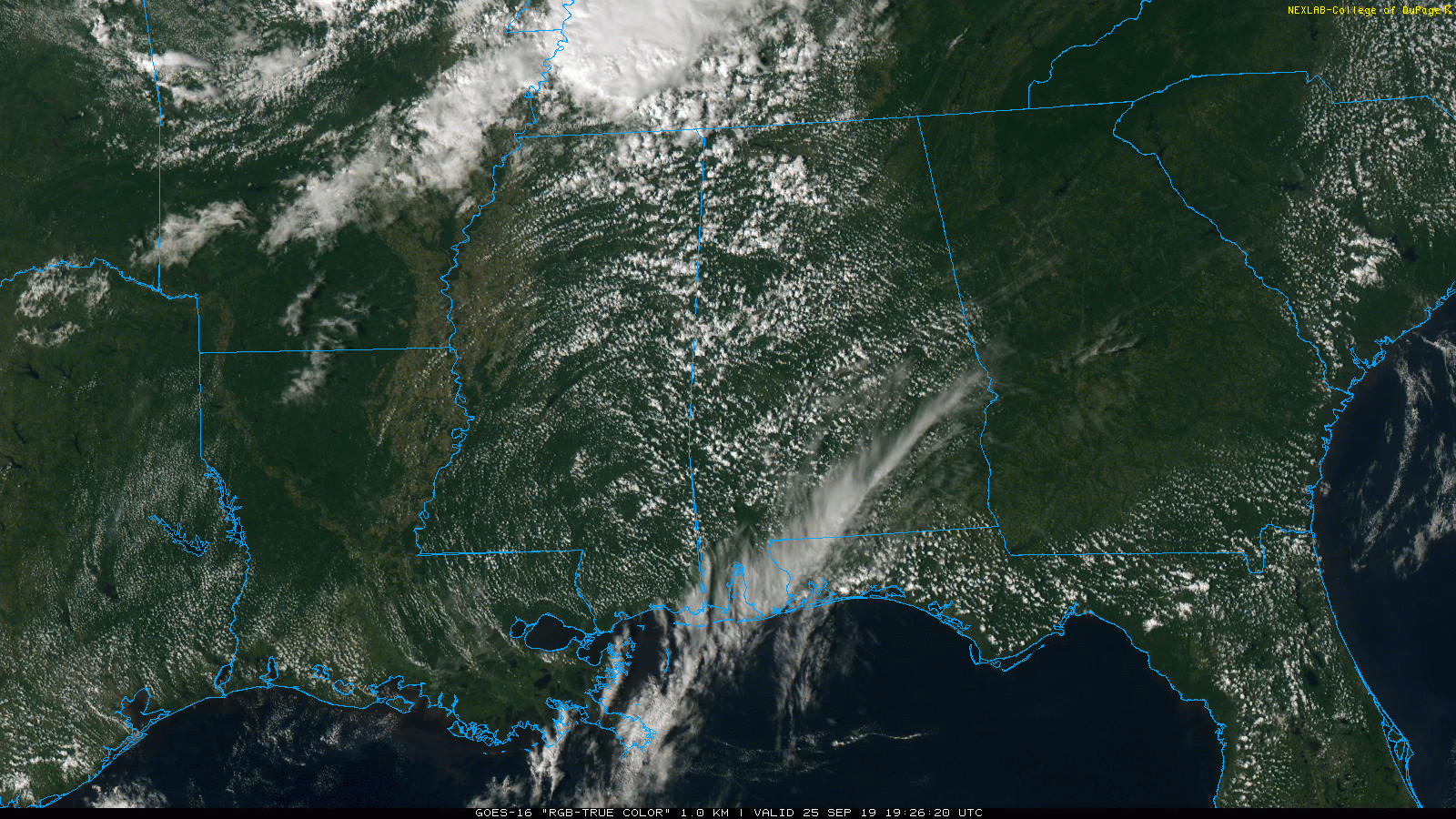
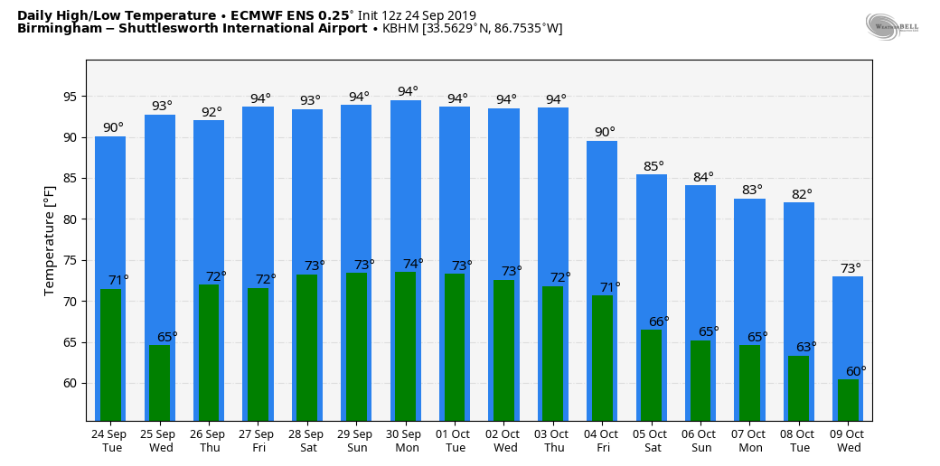
RADAR CHECK: We have a few isolated showers across Alabama this afternoon. They are moving east and will fizzle out once the sun goes down. Most places remain dry, and away from the showers temperatures are in the low to mid 80s. The average high for Sept. 25 at Birmingham is 82, and the record high is 98, set in 2016.
THURSDAY/FRIDAY: Not much change. A few isolated afternoon and evening showers and storms are possible both days, but odds of any one spot getting wet are only 10-20%. Days will be partly sunny with highs in the low to mid 90s.
THE ALABAMA WEEKEND: The strong upper ridge goes nowhere; the weekend looks mostly dry with a good supply of sunshine Saturday and Sunday along with highs in the mid 90s, right at record levels for late September in Alabama. Any afternoon showers will be few and far between, and mainly over the northeast counties of the state.
Here are the daily record highs:
- Sept. 28 — 94 (1986)
- Sept. 29 — 96 (1904)
NEXT WEEK: Don’t look for much change Monday through Wednesday; we’ll see only isolated showers and highs over 90 degrees. There is some hope heat levels come down late in the week in response to a cold front; the amount of cooling remains very much in question.
FOOTBALL WEATHER: It will be mostly clear and warm for the high school games Friday night. Temperatures will fall from the low 80s at kickoff into the 70s by the second half of the games.
Saturday, Alabama hosts Ole Miss at Bryant-Denny Stadium (2:30 p.m. kickoff). The sky will be sunny with temperatures in the mid 90s at kickoff, falling back to near 90 by the fourth quarter.
Auburn will host Mississippi State Saturday evening at Jordan-Hare Stadium (kickoff at 6). The sky will be clear with temperatures falling from near 89 at kickoff into the low 80s by the final whistle.
UAB travels to Bowling Green to take on Western Kentucky Saturday evening (kickoff at 6). Clear weather is the forecast with a kickoff temperature near 87 degrees, falling to near 80 by the fourth quarter.
Jacksonville State will also be on the road, playing Austin Peay in Clarksville, Tennessee, Saturday (kickoff at 2 p.m. Central). Expect a sunny sky with temperatures in the low 90s at kickoff, falling into the upper 80s by the end of the game.
TROPICS: Jerry is now post-tropical in the Atlantic; it is passing by Bermuda this afternoon as it moves eastward. Lorenzo, in the eastern Atlantic, is now the fifth hurricane of the season; it will turn northward well before reaching the U.S.
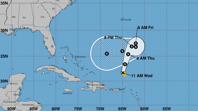
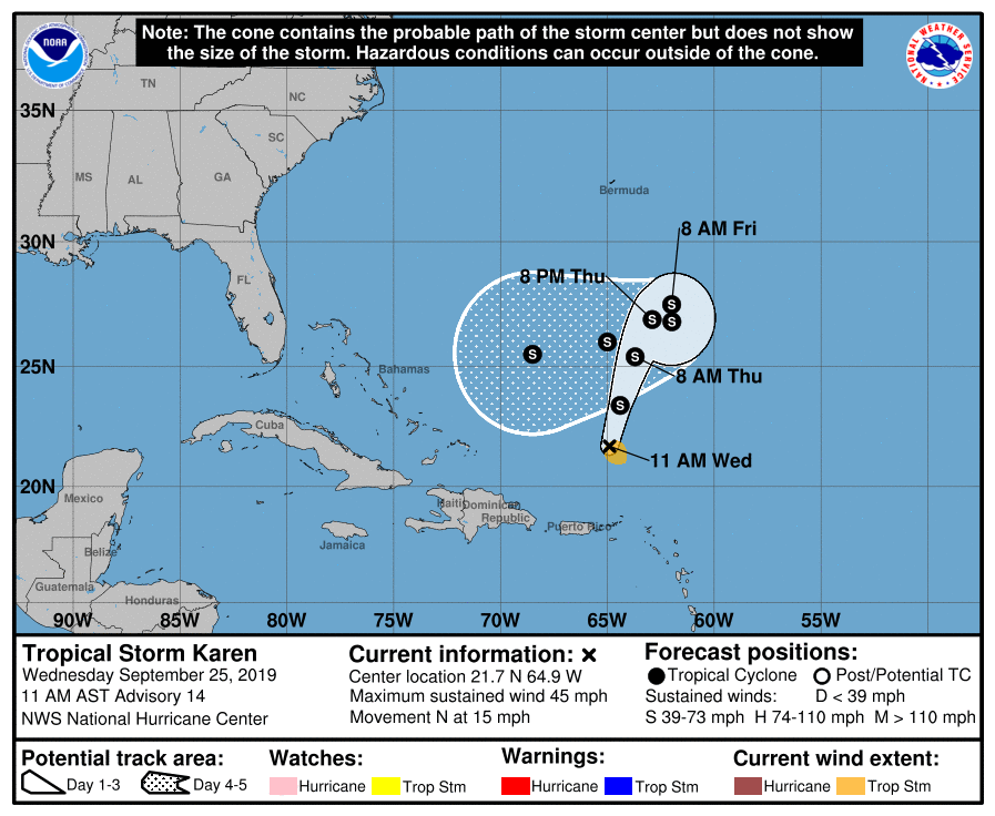
Tropical Storm Karen is producing winds of 45 mph and remains rather disorganized this afternoon. The system is expected to slow down, loop and bend back to the west/southwest this weekend in response to a strong ridge to the north. It remains to be seen whether Karen will survive the next five days and whether the system will affect Florida or the Gulf of Mexico. We will watch it closely.
COOL START THIS MORNING: Vic Bell, our Skywatcher at Black Creek, in Etowah County just northeast of Gadsden, reported a drop to 49 degrees this morning just before 6 — the first report of a temperature in the 40s in Alabama this fall. Many other North Alabama communities were in the low to mid 50s.
ON THIS DATE IN 1998: Four hurricanes were spinning simultaneously in the Atlantic basin: Georges, Ivan, Jeanne and Karl. That was the first time this had happened since 1893.
BEACH FORECAST: Click here to see the AlabamaWx Beach Forecast Center page.
WEATHER BRAINS: You can listen to our weekly 90-minute show any time on your favorite podcast app. This is the show all about weather featuring many familiar voices, including the meteorologists at ABC 33/40.
CONNECT: You can find me on the major social networks:
Facebook
Twitter
Instagram
Pinterest
Snapchat: spannwx
For more weather news and information from James Spann and his team, visit AlabamaWx.


