James Spann: One more week of record heat for Alabama, then a cool-down
James Spann forecasts record heat to start the Alabama work week from Alabama NewsCenter on Vimeo.
NUMBER TWO: The mean temperature this month so far at Birmingham is 82 degrees. This will wind up as the second-warmest September on record. The hottest was September 1925, when the mean was 84.2 degrees.
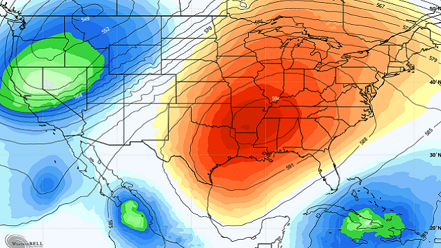
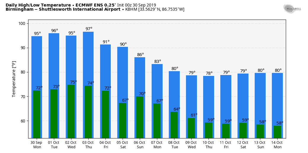
Our weather won’t change much this week as a very strong upper high remains right over us; look for partly to mostly sunny days, highs in the mid 90s and only isolated afternoon showers and thunderstorms.
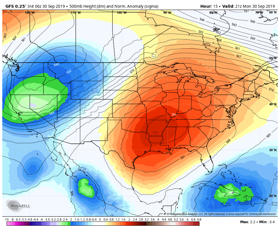
Birmingham’s hottest October temperature is 94 degrees, recorded in 1919, 1927, 1941 and 1954. There is a very high chance we beat that Tuesday through Friday on multiple days, meaning we will see our hottest October days on record.
BUT, TO THE WEST: While we have the strong upper high and record heat, the West is dealing with a deep upper trough along with snow and record cold. The high temperature in downtown Portland yesterday was 49 degrees, an all-time record earliest in the season that downtown highs failed to climb above the 40s in 145 years of record keeping there. The previous earliest was Oct 12, 1881.
THE ALABAMA WEEKEND: The ridge finally begins to break down, and heat levels will come down Saturday and Sunday with highs in the 80s. Showers remain isolated Saturday, but Sunday will bring a better chance of rain statewide as moisture from the Gulf of Mexico is allowed to flow northward. It probably won’t be a major rain event, but it will certainly help.
NEXT WEEK: Monday looks like a mostly cloudy day with showers possible; the high will be between 78 and 81. Then, for the rest of the week, highs will be around 80, with lows in the 57- to 62-degree range, quite the change from this ongoing heat wave.
RAIN UPDATE: Here are rain totals for the year, followed by the departure from average:
- Mobile — 46.43 inches (5.69 inches below average)
- Huntsville — 43.4 inches (3.49 inches above average)
- Tuscaloosa — 40.1 inches (0.84 of an inch above average)
- Birmingham — 37.06 inches (3.79 inches below)
- Anniston — 39.73 inches (1.98 inches above)
- Shelby County Airport — 33.87 inches (7.92 inches below)
- Montgomery — 33.81 inches (6.75 inches below)
TROPICS: Hurricane Lorenzo, in the Central Atlantic, is packing sustained winds of 105 mph and is moving northeast. It will clip the Azores Tuesday night, then becomes post-tropical in the North Atlantic late in the week. The rest of the Atlantic basin is quiet.
ON THIS DATE IN 1992: The coldest September ever recorded in interior Alaska was wrapping up. Fairbanks averaged a frigid 31.7 degrees, which was 13.2 degrees below normal and the first below-freezing September ever. Beginning on Sept. 9 and on every day for the rest of the month, a new record low was set for either low minimums or low maximums, or both. On this date, the city plunged to 3 degrees to set a new all-time record low for September. Snowfall for the month totaled 24.4 inches, which was more than three times the previous record for September.
BEACH FORECAST: Click here to see the AlabamaWx Beach Forecast Center page.
WEATHER BRAINS: You can listen to our weekly 90-minute show any time on your favorite podcast app. This is the show all about weather featuring many familiar voices, including the meteorologists at ABC 33/40.
CONNECT: You can find me on the major social networks:
Facebook
Twitter
Instagram
Pinterest
Snapchat: spannwx
For more weather news and information from James Spann and his team, visit AlabamaWx.


