Scott Martin: A little rain from Nestor for Alabama today
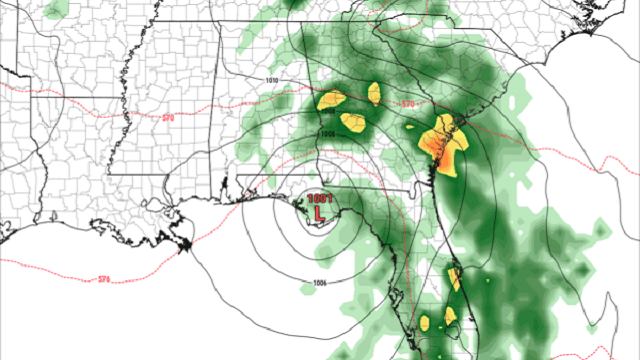
TODAY: At 6 a.m., radar showed some scattered shower activity on the eastern side of Alabama, mainly over portions of Talladega, Calhoun, Clay, Cleburne and Randolph counties, along with Chambers, Lee, Macon, Montgomery, Bullock, Pike and Barbour counties. These tropical showers are associated with Tropical Storm Nestor as it continues to move toward the Florida Gulf Coast. Speaking of Nestor, he is beginning to lose his tropical characteristics as the storm as a whole has elongated into a comma-shaped system.
 As of 4 a.m., Nestor’s winds had dropped to 50 mph and the minimum pressure was back up to 998 millibars. Tropical Storm Warnings are up from the Okaloosa/Walton county line to Yankeetown, Florida. Storm Surge Warnings are up from Indian Pass to Clearwater Beach.

Nestor is forecast to make landfall later this morning very close to Port St. Joe as forward motion continues to be to the northeast around 17 mph. That motion should continue through the rest of the day and into the morning Sunday before a turn to the east occurs late in the day. The center should move offshore off of the North Carolina coast late Sunday as a post-tropical storm.
Storm surges of 1 to 5 feet are expected along the Gulf Coast of Florida east of Port St. Joe all of the way around to Clearwater and Tampa.
Tropical-storm-force winds are expected to reach or are already reaching the coast within the Tropical Storm Warning area, and will continue through this afternoon.
Rainfall totals of 2 to 4 inches are expected this weekend across portions of the Southeast with isolated maximum amounts up to 8 inches.
A few tornadoes are possible through midday in the northern and central Florida peninsula, and later today and tonight over coastal areas of Georgia and the Carolinas.

For your Saturday in Alabama, we can expect most of the rain activity over the eastern half of the state. As you can see by the latest run of the Global Forecast System, much of the activity will have pushed over into much of Georgia, Tennessee and the Carolinas. Rain chances range from 30% to 80% across Alabama from west to east. Unfortunately, we are expecting only around one-quarter inch of rain and less, with the heavier totals well east of I-65. There will be a good many people who may not even see a raindrop today west of I-65. It will be a little breezy today, but the higher wind gusts should stay localized to the southeast corner of the state, mainly south of I-85, where gusts up to 20-30 mph are possible. Skies will be mostly cloudy to complete overcast, with highs reaching the lower 60s to the lower 70s. We should be dry late tonight and through the overnight hours with lows in the lower to mid-50s.
SUNDAY: Sunday will be a much warmer day across central Alabama as we’ll have warm air advection out ahead of an approaching cold front. Skies will start off mostly cloudy but will become mostly clear by the afternoon. Afternoon highs will get up into the upper 70s to the lower 80s. Nestor will be moving off of the East Coast and starting its eastward journey over the open waters of the Atlantic.
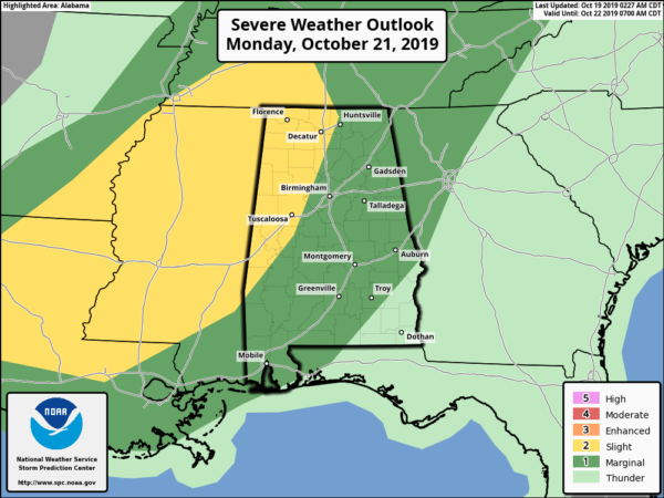
NEXT WEEK: On Monday, we’ll have a strong cold front begin to move into the western Alabama during the afternoon. The front will make it through the state and move into Georgia by the overnight hours. There will be just enough instability and shear that there will be a threat of isolated damaging winds and maybe a brief tornado or two. The main window for strong to severe storms will be from 3 p.m. Monday afternoon to 3 a.m. Tuesday morning. A slight risk is up west of a line from Hazel Green to Brookwood to Demopolis, while a marginal risk is up for much of the rest of north and central Alabama. Highs will be in the upper 70s to the lower 80s.
Tuesday will be a much cooler day with clearing skies after the front has moved through. There may be a few lingering showers over extreme eastern and southeastern Alabama, but we’ll be all dry by late morning. Highs will be in the upper 60s to the lower 70s.
High pressure will be in control of our weather on Wednesday. We’ll have sunny skies and mild temperatures, with highs in the lower 70s.
On Thursday, the high will move out over the Atlantic and the next impulse will be starting to get its act together west of us. We’ll start off with clear skies, but clouds will begin to build late. Rain chances will start to increase during the night, with showers possible. Highs will be in the lower to mid-70s.
Friday will feature a good chance of showers and maybe a few rumbles of thunder across Alabama. Skies will mainly be cloudy and highs will reach the mid-60s to the lower 70s.
For more weather news and information from James Spann, Scott Martin and other members of the James Spann team, including updates throughout the day on Tropical Storm Nestor and the potential for severe storms on Monday, visit AlabamaWx.


