James Spann: Rain ends in Alabama tonight; colder on Friday
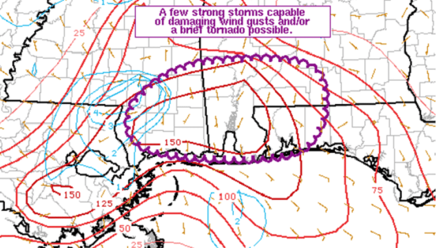
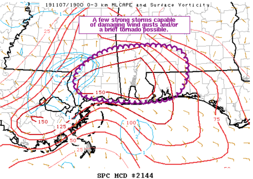
RADAR CHECK: Rain is fairly widespread across Alabama this afternoon ahead of a cold front near the Alabama/Tennessee border. The air has become unstable over far southwest Alabama, and a brief tornado is possible with storms there over the next few hours. Otherwise, expect rain with little, if any, thunder for the northern two-thirds of the state this evening.
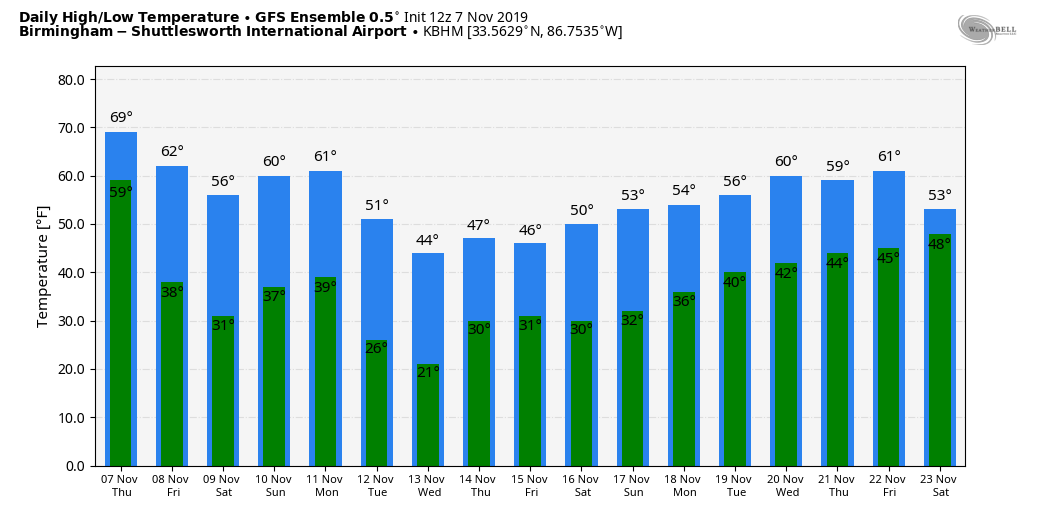
Rain will end tonight, and the sky clears after midnight as colder, drier air returns to the state. Friday will be sunny with a high between 50 and 55 degrees; the average high for Nov. 8 at Birmingham is 68.
THE ALABAMA WEEKEND: A freeze watch has been issued for much of north and central Alabama for Saturday morning; we project a low between 28 and 32 degrees for most communities, with mid to upper 30s for south Alabama. The day Saturday will be bright and sunny with a high around 60 degrees. The sky will remain sunny Sunday with a high in the mid 60s.
NEXT WEEK: Clouds increase Monday, ahead of the next cold front, and some light rain will likely move in here Monday night. Moisture will be limited. Then, on Tuesday, the coldest air so far this season blows into the state. Temperatures fall into the 30s over north Alabama, and they will likely hover between 35 and 40 through the afternoon with a biting north wind.
There is some chance we could see a snow flake or two over the Tennessee Valley of north Alabama as precipitation ends early Tuesday, but no impact is expected. The big story is the cold air.
The low will be close to 20 early Wednesday, with teens for colder pockets across north and central Alabama. Birmingham’s record low for Nov. 13 is 22, set way back in 1911, and that record is in danger. It rarely gets this cold before Thanksgiving in Alabama.
Wednesday will be a sunny day with a high in the upper 40s. The forecast is somewhat low confidence for Thursday and Friday; the American GFS global model shows a wave on the Gulf Coast with a chance of rain Thursday for the southern two-thirds of the state, while the European ECMWF model is dry on these two days.
 FOOTBALL WEATHER: It will be clear and cold for the high school games Friday night, with temperatures falling through the 40s.
Alabama hosts LSU Saturday in Tuscaloosa at Bryant-Denny Stadium (2:30 p.m. kickoff). The weather could not be any better for the biggest college game of the year — a sunny sky, with temperatures falling from near 61 at kickoff into the mid 50s by the final whistle. Sunset Saturday in Tuscaloosa comes at 4:52 p.m., so the fourth quarter will be played under the lights.
UAB will take on Southern Miss in Hattiesburg Saturday (2:30 p.m. kickoff). Expect clear weather for the game with temperatures falling from near 65 at kickoff to near 60 by the fourth quarter.
Jacksonville State will take on Tennessee Tech Saturday (kickoff at 1:30 p.m. Central) in Cookeville; the sky will be sunny with temperatures in the 55- to 60-degree range during the game.
ON THIS DATE IN 1951: At 7 a.m. Central Time a blinding flash, a huge ball of fire and a terrific roar occurred over parts of Texas, Oklahoma and Kansas, caused by a disintegrating meteor. Windows were broken in and near Hinton, Oklahoma, by the concussion.
BEACH FORECAST: Click here to see the AlabamaWx Beach Forecast Center page.
WEATHER BRAINS: You can listen to our weekly 90-minute show any time on your favorite podcast app. This is the show all about weather featuring many familiar voices, including the meteorologists at ABC 33/40.
CONNECT: You can find me on the major social networks:
Facebook
Twitter
Instagram
Pinterest
Snapchat: spannwx
For more weather news and information from James Spann and his team, visit AlabamaWx.


