James Spann: Very cold, windy day for Alabama; record lows early Wednesday

James Spann has the Alabama forecast for a cold November Tuesday from Alabama NewsCenter on Vimeo.
WINDY AND COLD: The Arctic cold front continues to push southward through Alabama this morning; just before daybreak light rain was mainly south of I-59, and it will continue to end from northwest to southeast. There is some sleet and freezing rain on the back side of the precipitation shield, but there is no impact.
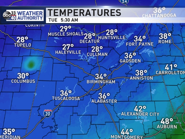
The sky will become sunny today, but the day will be very cold and windy. Temperatures won’t get out of the 30s despite the sun, and a strong north wind of 12-25 mph will keep the wind chill index below freezing all day.
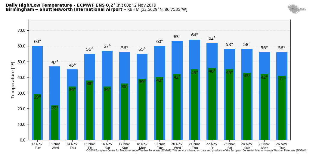
RECORD LOWS POSSIBLE: The wind will die down tonight, and with a clear sky we project a low for most north and central Alabama communities in the 18- to 24-degree range Wednesday morning. A freeze is expected all the way down to the Gulf Coast; Mobile and Pensacola will drop into the upper 20s. Here are some of the record lows for Nov. 13:
- Huntsville — 16 (1911)
- Birmingham — 22 (1911)
- Tuscaloosa — 22 (1968)
- Anniston — 24 (1968)
- Montgomery — 24 (1968)
- Mobile — 31 (1911)
The day Wednesday will be sunny, and the high will be close to 50 as a warming trend begins.
REST OF THE WEEK: Clouds slowly increase Thursday, and we will mention a decent chance of rain Thursday night for the southern two-thirds of the state. Global model data suggests rain is possible as far north as Tuscaloosa, Birmingham and Gadsden (I-59 corridor). Rain amounts should be light, generally less than one-half inch, as moisture will be limited. Then, on Friday, the sky becomes sunny as the wave in the Gulf moves on to the east. Look for a high in the low 50s Thursday and Friday.
THE ALABAMA WEEKEND: Look for mostly sunny, cool days and fair, cold nights; lows will be in the 30s, highs around 60. Colder pockets could visit the upper 20s Saturday morning.
NEXT WEEK: The week looks fairly dry with seasonal temperatures; highs most days will be in the low 60s. We could see some rain toward the end of the week with an approaching cold front, but for now it doesn’t look like a big rain event. On the positive side, there’s no sign of any severe weather issues for Alabama for the next seven to 10 days.
ON THIS DATE IN 1970: The deadliest tropical cyclone ever recorded and one of the deadliest natural disasters in modern times occurred in East Pakistan, now Bangladesh. The Bhola Cyclone first formed over the Bay of Bengal on Nov. 8 and traveled north. This cyclone reached peak intensity, Category 3, on Nov. 11 and made landfall on the coast of East Pakistan the following afternoon. The Bhola Cyclone killed an estimated 500,000 people and caused nearly $90 million in damage (in 1970 U.S. dollars).
BEACH FORECAST: Click here to see the AlabamaWx Beach Forecast Center page.
WEATHER BRAINS: You can listen to our weekly 90-minute show any time on your favorite podcast app. This is the show all about weather featuring many familiar voices, including the meteorologists at ABC 33/40.
CONNECT: You can find me on all of the major social networks:
Facebook
Twitter
Instagram
Pinterest
Snapchat: spannwx
For more weather news and information from James Spann and his team, visit AlabamaWx.