James Spann: Wet, stormy day for Alabama
James Spann has a wet midweek forecast for Alabama from Alabama NewsCenter on Vimeo.
ANOTHER SOAKER: A wave of low pressure will move along a stalled front just north of the Gulf Coast today, setting the stage for a wet, stormy day for Alabama with the dual threat of flash flooding and severe thunderstorms.
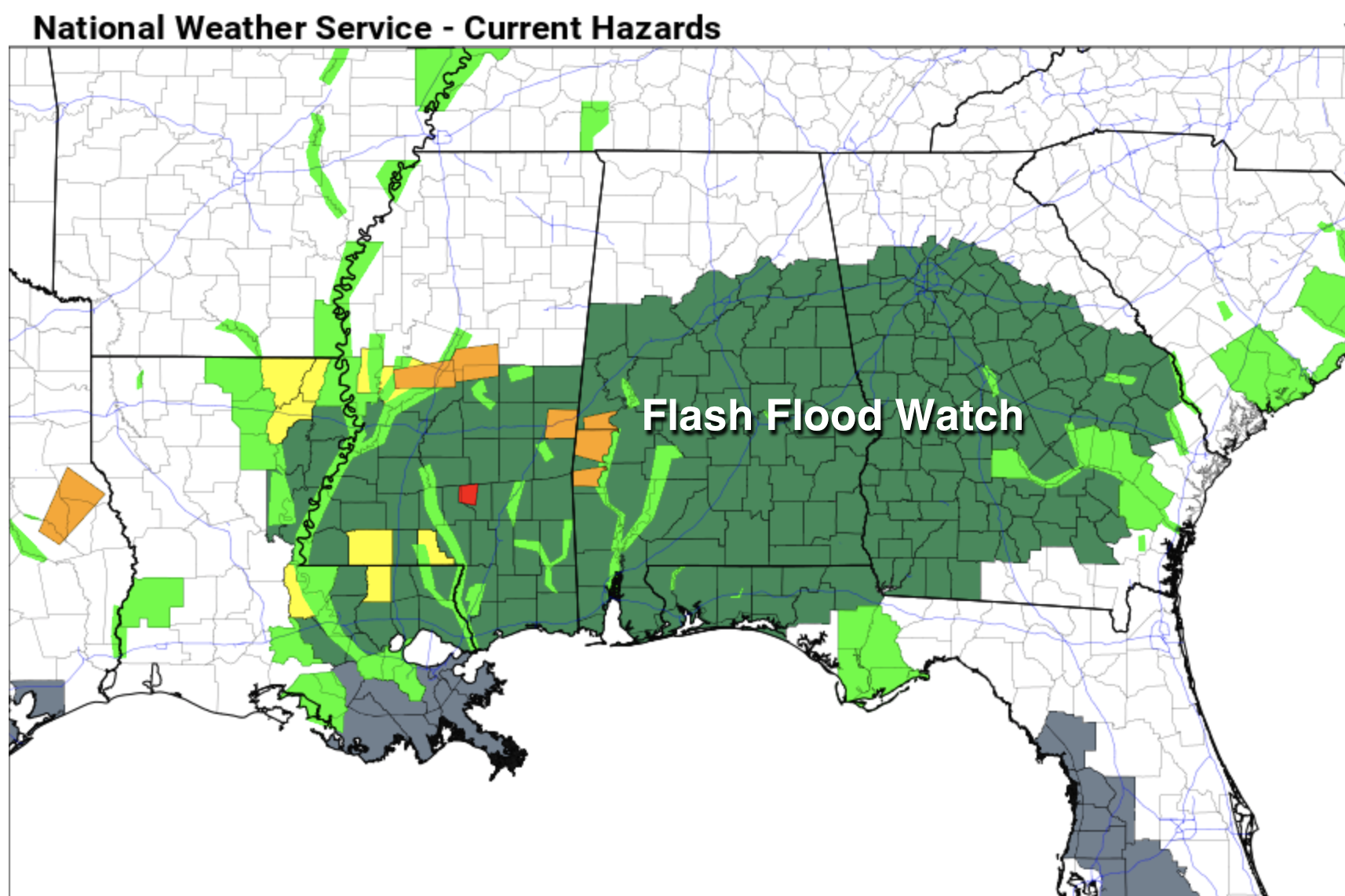
FLOODING: A flash flood watch is in effect for the southern two-thirds of Alabama through midday Thursday. The watch is basically for areas along and south of I-20; additional rain amounts of 1 to 3 inches are expected over the next 30 hours. Amounts will be lighter over the northern third of the state.
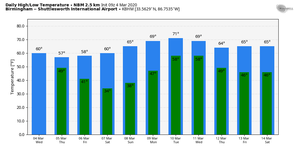
The air will be cool and stable, with temperatures in the 50s in cities like Tuscaloosa, Birmingham, Anniston and Gadsden, and severe storms are not expected in that part of the state.
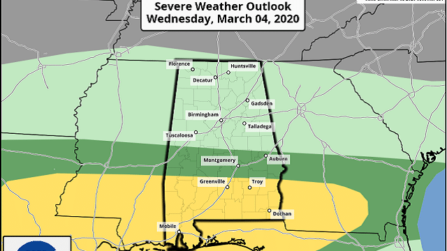
SEVERE THUNDERSTORMS: The Storm Prediction Center continues to define a slight risk (level 2 out of 5) of severe thunderstorms today for roughly the southern third of Alabama, areas south of a line from Sweetwater to Fort Deposit to Eufaula. A tornado watch is in effect for much of southwest Alabama until 10 this morning.
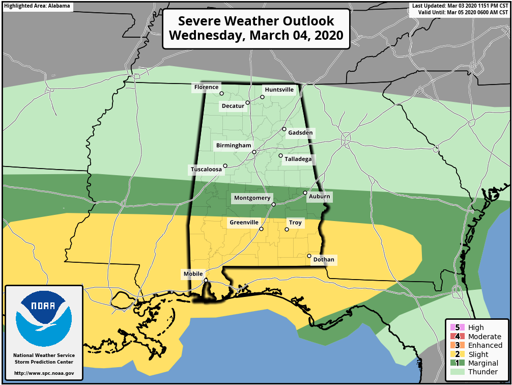
Thunderstorms over south Alabama will be capable of producing large hail, damaging winds and possibly a few tornadoes. Several storms early this morning are producing large hail south of U.S. 80.
THURSDAY/FRIDAY: Rain will end from west to east Thursday as drier air pushes into the state; we could begin to see some clearing by afternoon. On Friday, look for sunshine back in full force. We start the day in the upper 30s; the high Friday afternoon will be around 60 degrees.
THE ALABAMA WEEKEND: Dry weather continues. Saturday morning will be cold, with a low in the upper 20s and low 30s, but we warm into the 57- to 60-degree range by afternoon with a sunny sky. On Sunday, sunny weather continues with a high in the mid 60s.
NEXT WEEK: Moist air returns, and showers are possible Monday and Tuesday. The chance of rain could linger into Wednesday, but there is a good bit of model inconsistency. The latter half of the week looks dry and mild for now.
ON THIS DATE IN 1873: The second inauguration of Ulysses S. Grant remains Washington, D.C.’s, record cold March day. The low was 4 degrees, and by noon, with the sunshine, the temperature was 16 degrees. Wind chills were around 30 degrees below zero. The 40 mph winds made his inaugural address inaudible to most on the platform with him.
BEACH FORECAST: Click here to see the AlabamaWx Beach Forecast Center page.
WEATHER BRAINS: You can listen to our weekly-90 minute show any time on your favorite podcast app. This is the show all about weather featuring many familiar voices, including the meteorologists at ABC 33/40.
CONNECT: You can find me on the major social networks:
Facebook
Twitter
Instagram
Pinterest
Snapchat: spannwx
For more weather news and information from James Spann and his team, visit AlabamaWx.com.


