James Spann: Strong to severe storms possible in Alabama Tuesday evening
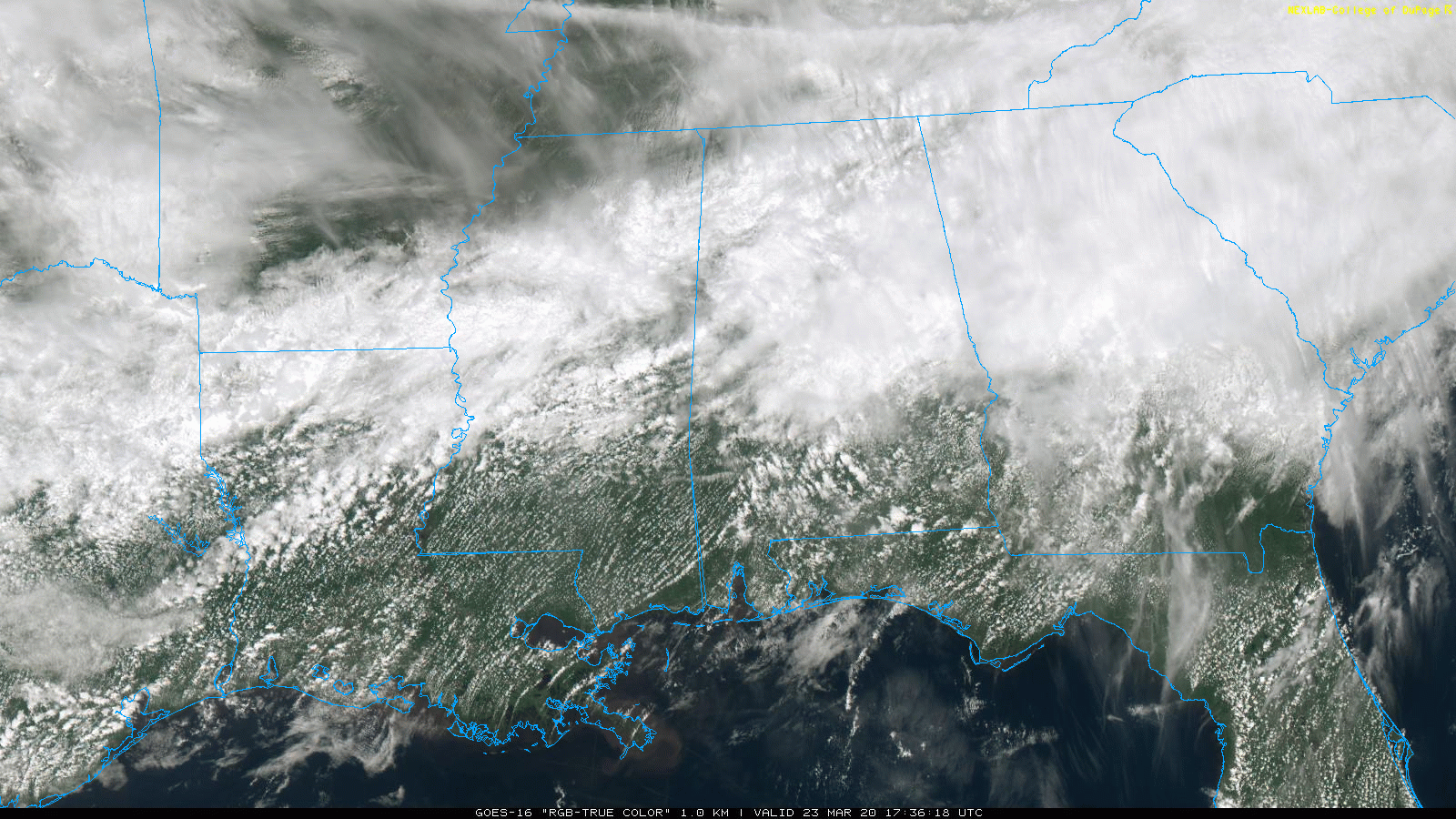
WET MONDAY: Rain, mostly light to moderate, continues across parts of north and central Alabama this afternoon. The sky is cloudy, and temperatures are mostly in the 60s. On the positive side, the Storm Prediction Center has removed the marginal risk of severe thunderstorms for today and tonight. Rain will diminish this evening, although a few scattered showers could linger through the night.
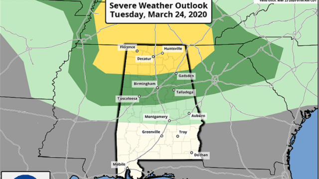
TUESDAY: Any showers Tuesday morning should be widely spaced, but showers and thunderstorms will increase by late afternoon and early Tuesday night as a surface low forms northwest of Alabama, aided by an upper trough. Some of the storms could become strong to severe; the Storm Prediction Center has a slight risk (level 2 of 5) defined for north Alabama, north of a line from Winfield to Oneonta to Centre. A marginal risk (level 1 of 5) extends as far south as Eutaw, Jemison and Roanoke.
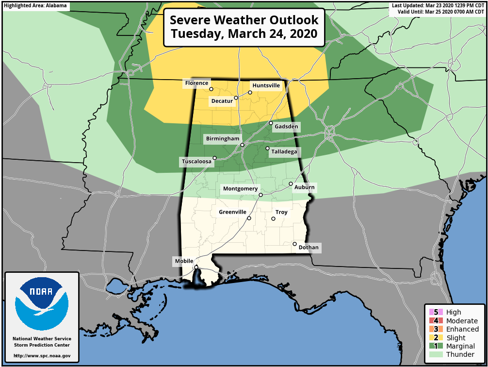
The main window for heavier storms will come from 3 until 9 p.m. The main risks will come from hail and strong straight-line winds, but an isolated tornado can’t be ruled out, especially over the northern third of the state. Just be sure you have a way of hearing severe weather warnings Tuesday evening if they are needed. We are in the core of the spring tornado season in Alabama.
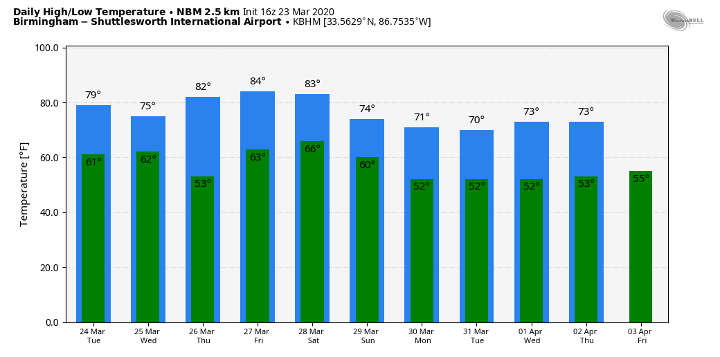
REST OF THE WEEK: Drier air returns Wednesday, and Alabama will be rain-free through Friday with sunny, warm afternoons and fair, pleasant nights. The high will be in the mid 70s Wednesday, followed by mid 80s Thursday and Friday. These two days should be the warmest so far in 2020 for most communities across Alabama.
THE ALABAMA WEEKEND: The day Saturday will be dry and warm with a high in the 80s; a cold front will bring a band of showers and thunderstorms Saturday night or early Sunday. New model data hints that the rain could end fairly early in the day Sunday, followed by a clearing sky and a high between 68 and 71. It’s too early to know if severe storms will be an issue Saturday night; we will have better clarity after the system Tuesday night exits the state.
NEXT WEEK: The first half of the week looks dry and pleasant with highs in the 70s. A few showers could return late in the week, but for now it doesn’t look like a major event.
ON THIS DATE IN 1932: Cleanup continued after a superoutbreak of tornadoes on March 21 across the Deep South. The 1932 outbreak produced 10 violent tornadoes, classified EF4 or EF5 on the Fujita scale of tornado intensity, eight of which occurred in Alabama alone, and is surpassed only by the March 1952 tornado outbreak, with 11 violent tornadoes; the 2011 Super Outbreak, with 15; the 1965 Palm Sunday tornado outbreak, with 17; and the 1974 Super Outbreak, with 30. Nobody knows exactly how many died in Alabama, but the death toll was at least 268. Thousands more were injured. Some of the hardest-hit counties were Tuscaloosa, Talladega, Cullman, Chilton, Marengo, Clay, Shelby and Perry. Near Faunsdale on U.S. 80 in northeast Marengo County, east of Demopolis, the owner of an 800-acre plantation found a horse collar, a dead pig and the body of a 3-year-old child all jammed together in a hollow tree stump.
BEACH FORECAST: Click here to see the AlabamaWx Beach Forecast Center page.
WEATHER BRAINS: You can listen to our weekly 90-minute show any time on your favorite podcast app. This is the show all about weather featuring many familiar voices, including the meteorologists at ABC 33/40.
CONNECT: You can find me on all of the major social networks:
Facebook
Twitter
Instagram
Pinterest
Snapchat: spannwx
For more weather news and information from James Spann and his team, visit AlabamaWx.


