James Spann: Alabama stays mostly dry today; rain, storms return Tuesday
James Spann forecasts a quiet Monday, stormy Tuesday for Alabama from Alabama NewsCenter on Vimeo.
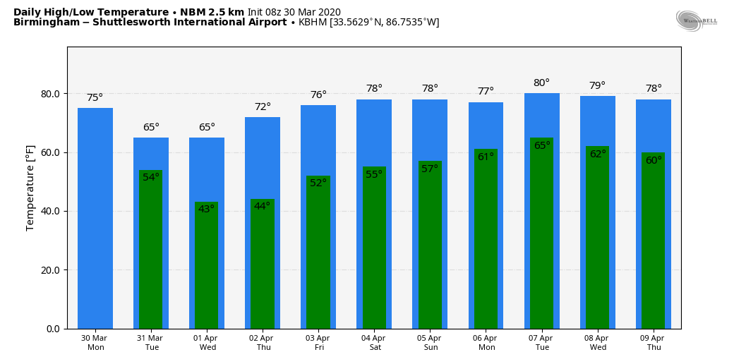
QUIET MONDAY: We do note a few small patches of light rain across the state early this morning, but most of the day should be rain-free with a mix of sun and clouds; temperatures reach the mid 70s this afternoon. The average high for Birmingham on March 30 is 70.
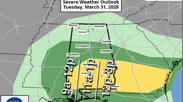
ACTIVE DAY TUESDAY: Rain and thunderstorms will return to the state Tuesday. The Storm Prediction Center has defined a slight risk (level 2 out of 5) of severe thunderstorms for areas south of a line from Linden to Clanton to Opelika, with a marginal risk (level 1 of 5) as far north as Jasper and Jacksonville.
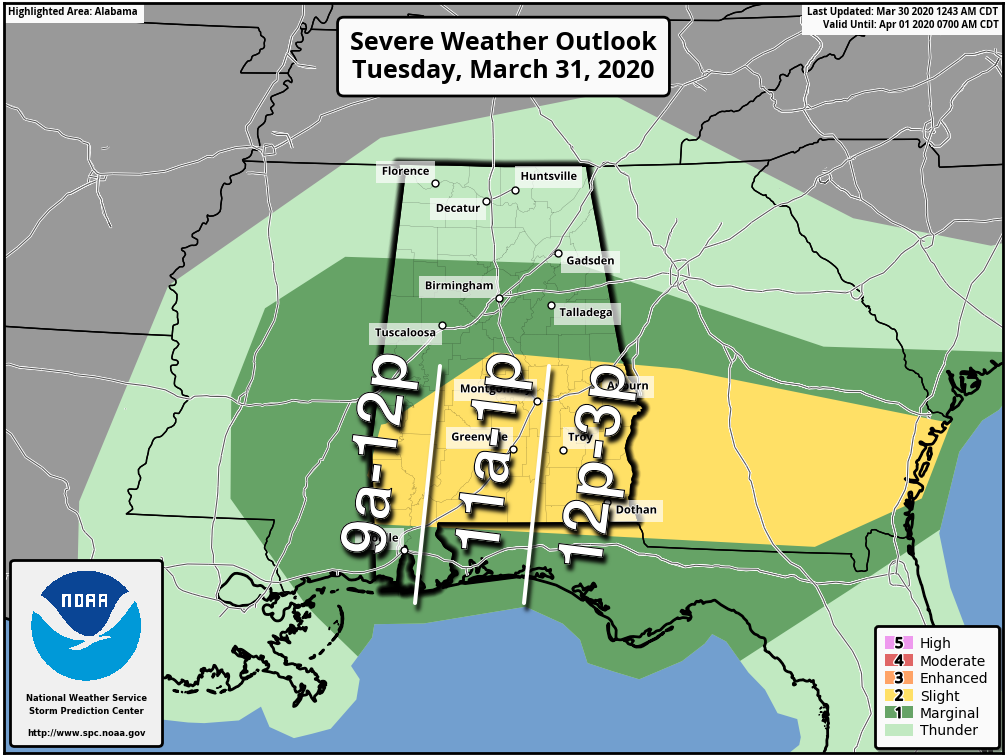
The air over the northern half of the state will be cool and stable; the severe weather threat will be confined to the southern counties of Alabama. The main window for severe weather there will open up around mid-morning, continuing through the early afternoon. A few storms over south Alabama will be capable of producing hail and strong winds. An isolated tornado or two is certainly possible as well.
Rain amounts should be around one-half inch for most communities, and the rain will end from west to east during the afternoon. Temperatures over north Alabama won’t get past the mid 60s; 70s are likely for south Alabama.
REST OF THE WEEK: The weather looks dry Wednesday through Friday with mostly sunny days and fair nights. Wednesday morning will be pretty chilly; look for upper 30s over the northern third of the state, and some patchy, light frost can’t be ruled out for the colder valleys and protected areas. The high will be in the 63- to 66-degree range Wednesday, followed by low 70s Thursday and mid 70s Friday.
THE ALABAMA WEEKEND: The next wave brings rain into the state Saturday. Severe storms are not expected, and it won’t rain all day. But periods of rain are likely, with a high in the 70s. Sunday looks dry with a mix of sun and clouds and a high in the mid to upper 70s.
NEXT WEEK: Global models suggest rain returns to the state Monday, followed by mild weather for the midweek period, with highs mostly in the 70s.
While models still don’t show strong signals for a morning with widespread frost or freezing temperatures, I will fully expect at least one more shot at it before the season is over. Longtime Alabama residents know of “blackberry winter.”
STORMS THIS PAST WEEKEND: Severe storms before dawn produced hail to 3 inches in diameter over parts of Lamar and Fayette counties. Scattered wind damage was reported over parts of Winston and Cullman counties.
ON THIS DATE IN 2016: Early in the evening, a localized but significant tornado event impacted Oklahoma and Arkansas, including an EF2 that caused heavy damage to homes, businesses and industrial buildings in the northern part of Tulsa, injuring four people.
BEACH FORECAST: Click here to see the AlabamaWx Beach Forecast Center page.
WEATHER BRAINS: You can listen to our weekly 90-minute show any time on your favorite podcast app. This is the show all about weather featuring many familiar voices, including the meteorologists at ABC 33/40.
CONNECT: You can find me on all of the major social networks:
Facebook
Twitter
Instagram
Pinterest
Snapchat: spannwx
For more weather news and information from James Spann and his team, visit AlabamaWx.com.


