James Spann: Alabama’s quiet weather pattern continues through the weekend
James Spann forecasts another mild, dry day for Alabama from Alabama NewsCenter on Vimeo.
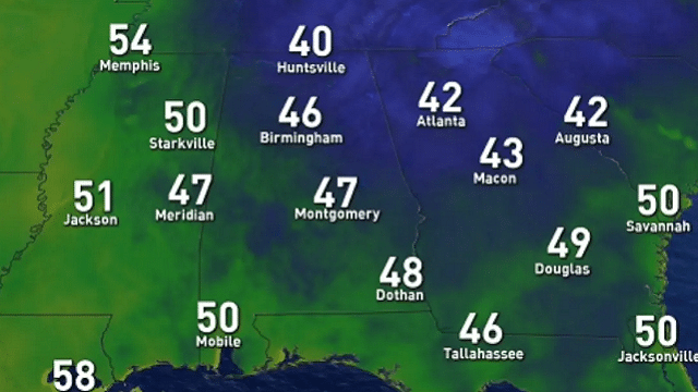
ANOTHER COLD START: Here are some temperatures across Alabama just before daybreak:
- Black Creek — 31
- Fort Payne — 32
- Valley Head — 32
- Cullman — 35
- Scottsboro — 37
- Heflin — 38
- Decatur — 38
- Huntsville — 38
- Haleyville — 39
- Gadsden — 39
- Anniston — 39
- Alexander City — 39
- Tuscaloosa — 45
- Montgomery — 46
- Birmingham — 47
- Mobile — 52
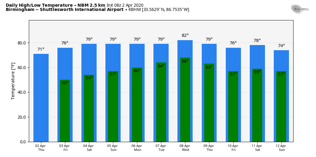
Look for a high around 70 degrees this afternoon with a good supply of sunshine. The average high for Birmingham on April 2 is 71.
FRIDAY AND THE WEEKEND: Dry weather continues Friday; with a partly sunny sky the high will be in the 75- to 78-degree range. Then, for the weekend, expect a mix of sun and clouds Saturday and Sunday. A few isolated showers can’t be ruled out, but they should be few and far between. Odds of any one spot getting wet are only 10% Saturday and 20% Sunday. Highs will be mostly in the upper 70s both days.
NEXT WEEK: A moist, unstable air mass will cover Alabama through the week, but there is no well-defined trigger for rain. This will set up a summer-like pattern with the risk of random, scattered showers and thunderstorms daily. The rain won’t be too widespread over the first half of the week, but there is evidence an upper trough could bring higher rain coverage late in the week, along with some potential for strong to severe thunderstorms.
STORM SURVEYS: Surveys determined five tornadoes touched down in the thunderstorms Tuesday morning in the Birmingham National Weather Service County Warning Area — four EF-0s and one EF-2. The EF-2 moved through the southern part of Eufaula; three of the EF-0 tornadoes were in Pike County and the other was in Montgomery County. There were no injuries.
ON THIS DATE IN 1957: An EF-3 tornado tore through Dallas, Texas. Ten people were killed and 216 injured. Total damage was $1.5 million. This tornado was among the most photographed and studied in history. It touched down along present-day I-20 in southern Dallas County. The twister moved north along Polk Street past the current location of I-30. Continuing north, it moved one mile east of Hampton Street, down a hill and into a neighborhood, destroying many homes. The tornado moved northwest of downtown Dallas, going across the Trinity River levee and into an industrial complex. It finally entered the rope, or dying, stage in the parking lot of Love Field, and fully dissipated after crossing Bachman Lake.

ON THIS DATE IN 2009: An EF-1 tornado moved through northern Tuscaloosa County near Samantha. Numerous hardwood and softwood trees were snapped off and uprooted along the damage path. The path was one-half mile long and was 150 yards wide at its widest point. No injuries or fatalities were reported.
BEACH FORECAST: Click here to see the AlabamaWx Beach Forecast Center page.
WEATHER BRAINS: You can listen to our weekly 90-minute show any time on your favorite podcast app. This is the show all about weather featuring many familiar voices, including the meteorologists at ABC 33/40.
CONNECT: You can find me on all of the major social networks:
Facebook
Twitter
Instagram
Pinterest
Snapchat: spannwx
For more weather news and information from James Spann and his team, visit AlabamaWx.com.


