James Spann: Wet weather for Alabama through Friday
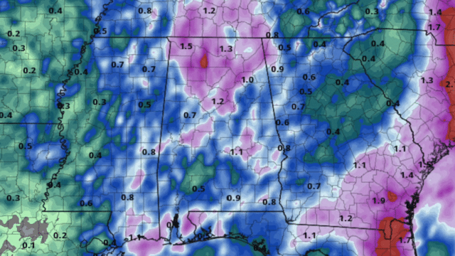
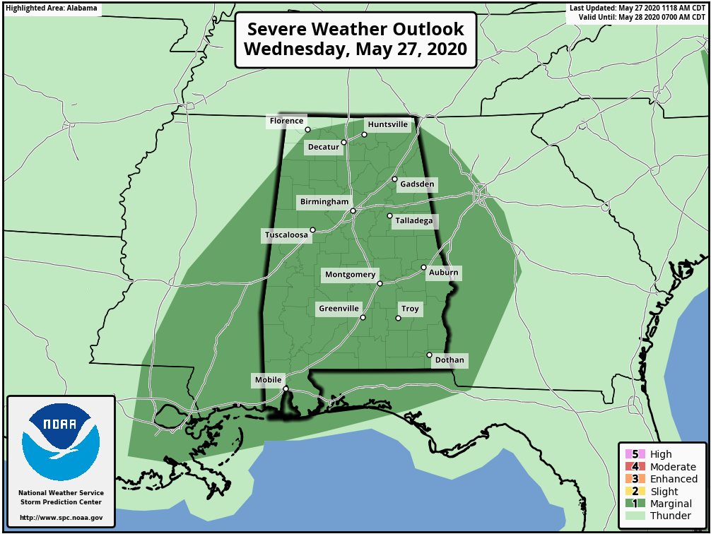
RADAR CHECK: A large area of rain and thunderstorms covers much of Alabama this afternoon; storms remain below severe limits, but they are producing very heavy amounts of rain, and flooding is possible. The Storm Prediction Center maintains a low-end, marginal risk of severe thunderstorms for much of the state through the evening; heavier storms could produce small hail and gusty winds.
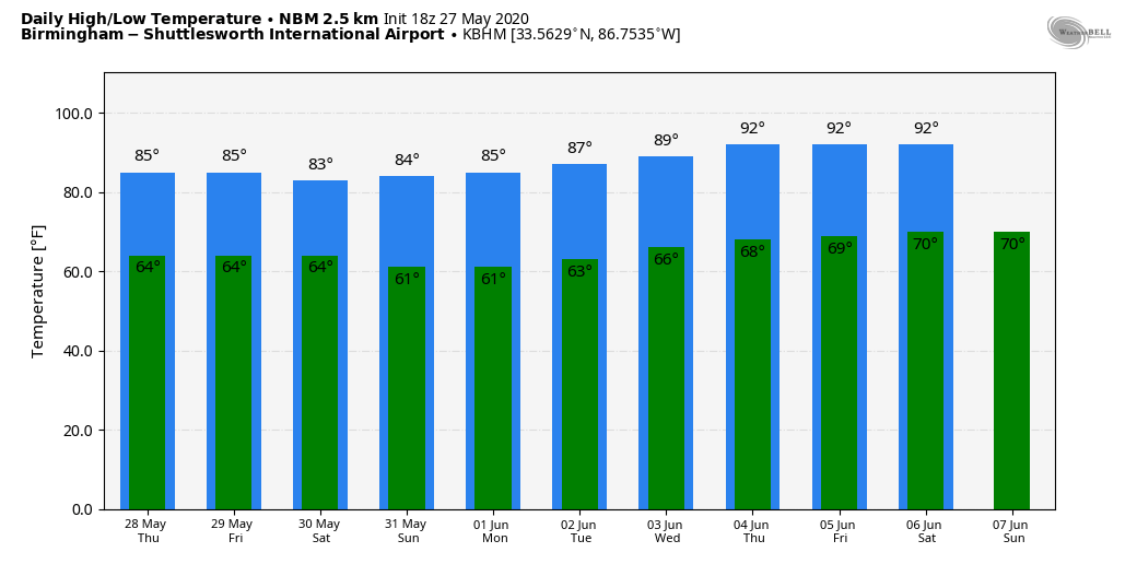
Temperatures remain below average, with readings mostly in the 70s. The average high for Birmingham on May 27 is 84.
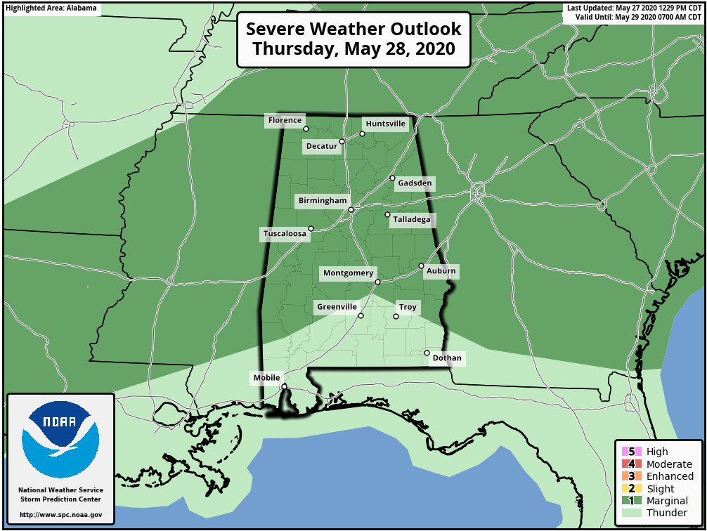
An upper low to the west will continue to move slowly eastward, and we expect scattered to numerous showers and thunderstorms Thursday and Friday. The rain won’t be continuous, but a few strong storms will be possible and the rain could be heavy at times. A decent part of the state is in a marginal risk again Thursday.
We expect a high in the low to mid-80s Thursday and Friday, with some sun at times.
THE ALABAMA WEEKEND: Unusually dry air drops into the state over the weekend. Look for sunny days, fair nights and lower humidity levels. Highs will be in the low 80s Saturday and Sunday. Many places will see a low in the cool 50s early Sunday, very pleasant for the end of May in Alabama.
NEXT WEEK: The weather looks generally dry next week with a warming trend; afternoon highs should reach the low 90s by Thursday and Friday. Showers will be few and far between during the week.
TROPICS: Tropical Storm Bertha formed quickly early this morning just off the South Carolina coast; it is now inland and moving northward, producing heavy rain as a tropical depression. The rest of the Atlantic basin is quiet.
ON THIS DATE IN 1973: A long-track F4 tornado touched down northeast of Demopolis and traveled northeastward. The tornado produced damage in Greensboro, Brent, Centreville, Montevallo, Columbiana, Wilsonville, Childersburg and many areas in between before lifting near Mount Cheaha. In Greensboro, 72 people were injured and one person was killed. Ninety percent of the town of Brent was destroyed; five people there were killed and 56 injured. In all, 216 buildings were destroyed, 570 buildings were damaged, 97 mobile homes were destroyed and 45 businesses were damaged or destroyed. More than 12,000 acres of timber was destroyed.
On the same day, May 27, 1973, an F3 tornado touched down northeast of the city of Tarrant and traveled through Center Point, where most of the damage from this storm occurred, including one fatality caused by the collapse of a home onto a family taking shelter in their basement. Thirty-two frame homes and 48 mobile homes were destroyed. More than 300 homes sustained minor damage in this area, as well. The storm then continued northeast, passing south of Springville, near St. Clair Springs, just to the north of Ashville and lifted near Gadsden.
BEACH FORECAST: Click here to see the AlabamaWx Beach Forecast Center page.
WEATHER BRAINS: You can listen to our weekly 90-minute show anytime on your favorite podcast app. This is the show all about weather featuring many familiar voices, including the meteorologists at ABC 33/40.
CONNECT: You can find me on the major social networks:
Facebook
Twitter
Instagram
Pinterest
Snapchat: spannwx
For more weather news and information from James Spann and his team, visit AlabamaWx.


