James Spann: Showers, storms a bit more numerous in Alabama Tuesday, Wednesday
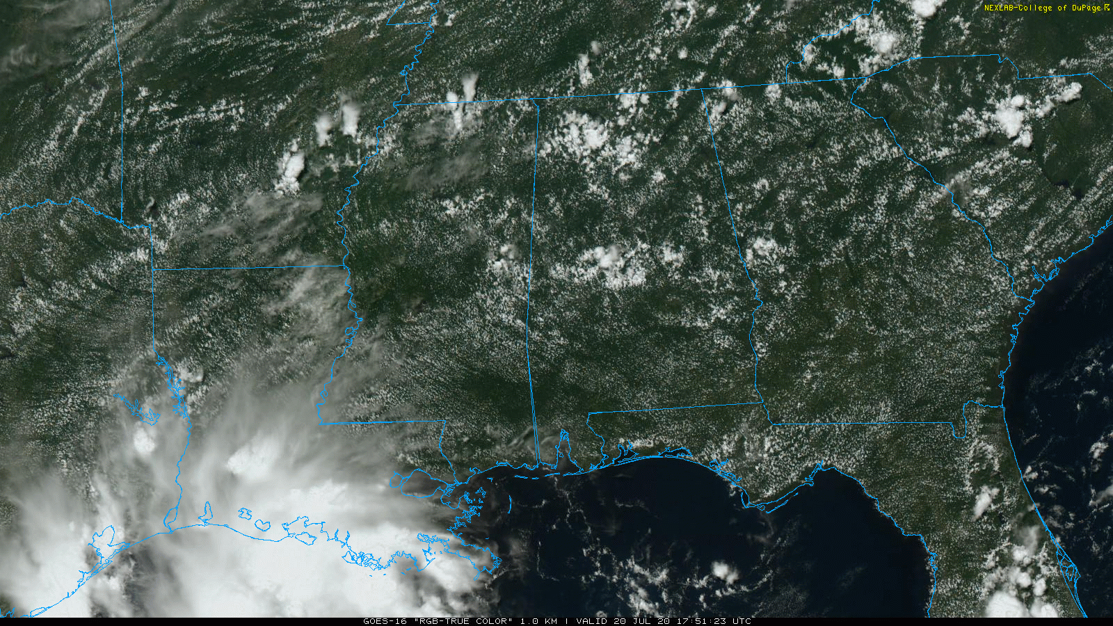
TYPICAL SUMMER AFTERNOON: It is a hot, humid day across Alabama with temperatures mostly in the low to mid 90s and random, scattered showers and thunderstorms showing little movement. A few spots are getting heavy amounts of rain, but most places are bone dry. Showers will fade away after sunset as the air cools and becomes more stable.
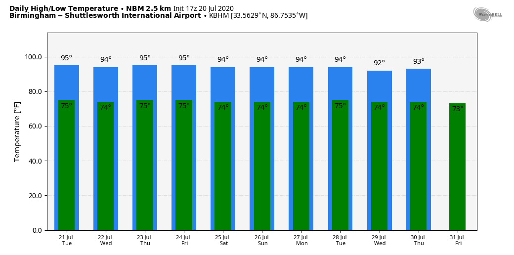
TUESDAY AND WEDNESDAY: Precipitable water values are expected to increase a bit, meaning scattered showers and thunderstorms should be a little more numerous both days. It won’t rain everywhere, but many neighborhoods should get a decent shower or storm. Otherwise, look for a mix of sun and clouds with highs between 92 and 95.
THURSDAY THROUGH THE WEEKEND: We will keep the summer persistence forecast going with very standard weather for late July in Alabama — partly sunny, hot, humid days with scattered, mostly afternoon and evening showers and thunderstorms. The chance of any one spot getting wet each afternoon will be 25% to 30%, with highs remaining in the 90s. Lows will be in the 70s.
NEXT WEEK: There’s no sign of any major weather change as the upper ridge holds across the southern U.S. Look for hot, humid days with a few scattered showers and storms each afternoon. Highs will remain in the 90s.
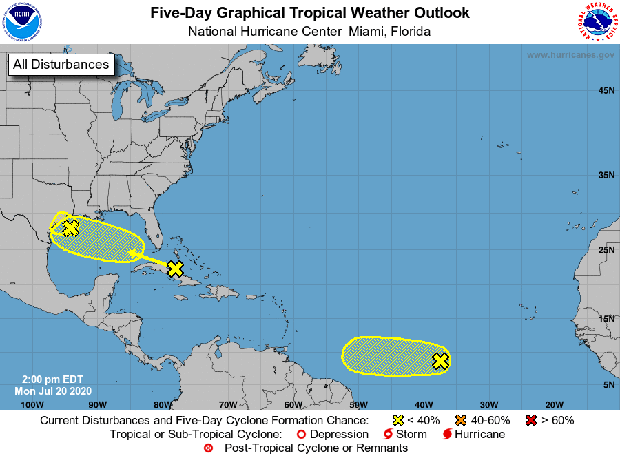
TROPICS: The National Hurricane Center is watching three tropical waves this afternoon. One is over the northwest Gulf of Mexico; the associated shower and thunderstorm activity has become a little better organized during the past several hours. The system is expected to move inland over Texas tonight or Tuesday before significant additional development can occur. Regardless of development, locally heavy rainfall is possible over portions of southeastern Texas and southern Louisiana during the next day or two.
A tropical wave is over Cuba. This system is expected to move west-northwestward through the Straits of Florida this afternoon and tonight, over the southeastern Gulf of Mexico by Tuesday and across the central Gulf on Wednesday, reaching the northwestern Gulf on Thursday. Environmental conditions could become a little more conducive for development of this system once it reaches the Gulf of Mexico. An Air Force Reserve Hurricane Hunter aircraft is scheduled to investigate the system Tuesday, if necessary.
There is also a low-latitude wave about halfway between the coast of Africa and the Windward Islands; environmental conditions are expected to be marginally conducive for development of this system during the next few days while it moves westward at 10 to 15 mph over the tropical Atlantic. By Friday and over the weekend, conditions are forecast to become less favorable for tropical cyclone formation.
ON THIS DATE IN 1977: A flash flood hits Johnstown, Pennsylvania, killing 84 people and causing millions of dollars in damages. This flood came 88 years after the infamous Great Flood of 1889 that killed more than 2,000 people in Johnstown.
ON THIS DATE IN 2005: Hurricane Emily made landfall in northern Mexico. When sustained winds reached 160 mph on July 16, Emily became the strongest hurricane ever to form before August, breaking a record set by Hurricane Dennis just six days before. It was also the earliest Category 5 hurricane ever recorded in the Atlantic basin, beating Hurricane Allen’s old record by nearly three weeks.
BEACH FORECAST: Click here to see the AlabamaWx Beach Forecast Center page.
WEATHER BRAINS: You can listen to our weekly 90-minute show anytime on your favorite podcast app. This is the show all about weather featuring many familiar voices, including the meteorologists at ABC 33/40.
CONNECT: You can find me on all of the major social networks:
Facebook
Twitter
Instagram
Pinterest
Snapchat: spannwx
For more weather news and information from James Spann and his team, visit AlabamaWx.