James Spann: Only isolated showers for Alabama today; lower humidity Saturday
James Spann forecasts a mostly quiet day, weekend for Alabama from Alabama NewsCenter on Vimeo.
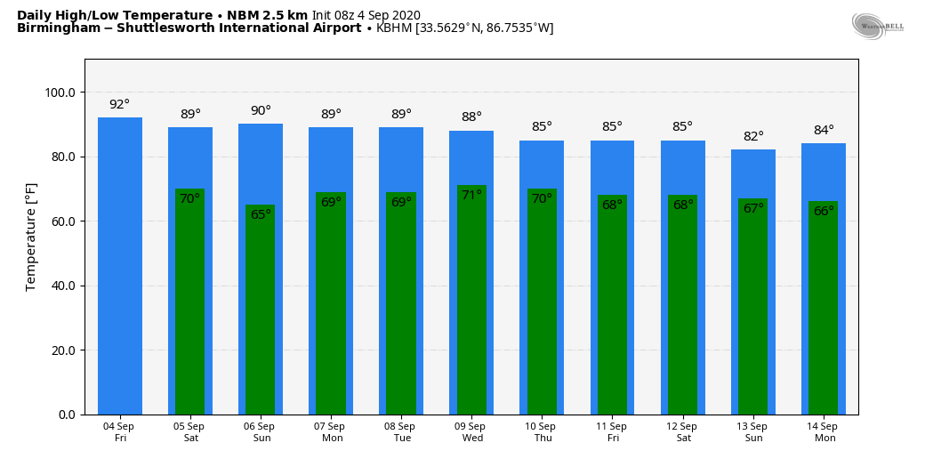
QUIET WEATHER THROUGH THE HOLIDAY WEEKEND: Today will be another mostly sunny day for Alabama with a high in the low 90s; the average high for Sept. 4 at Birmingham is 89. We will mention a few isolated showers this afternoon or early tonight over the northern third of the state ahead of a cold front, but moisture will be very limited and most places will remain dry.
Saturday will be a very nice day to start the Labor Day weekend, with a sunny sky, lower humidity and a high in the mid 80s. Temperatures will drop well down into the 60s early Sunday morning; there might be a spot or two in the upper 50s over north Alabama. Sunday will be partly to mostly sunny with only a small risk of a shower over east or southeast Alabama; the high will be in the mid to upper 80s. On Monday we are forecasting a mix of sun and clouds, some risk of widely scattered showers and a high between 85 and 88 degrees.
NEXT WEEK: We expect a gradual increase in the number of scattered showers and storms through midweek ahead of an upper trough and cold front. The latest global model runs are trending westward with the big upper trough, which means the surface front could hold up a little west of Alabama, keeping the chance of showers in the forecast through Thursday and Friday. Highs through the week will be in the mid to upper 80s, right at seasonal averages.
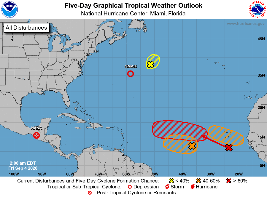
TROPICS: The attention is on the eastern Atlantic, where the National Hurricane Center is monitoring three distinct waves. All three have either a high or medium chance of development over the next five days; it remains too early to know if any of them will affect the U.S. But keep in mind we are very close to the climatological peak of the hurricane season, and most seasonal outlooks are indicating above-average activity in the Atlantic basin for the rest of the season.
On the positive side, the Gulf of Mexico will remain very quiet through the Labor Day weekend, meaning no tropical trouble for the central Gulf Coast (Gulf Shores to Panama City Beach). The weather there will be pretty routine, with the usual mix of sun and a few scattered thunderstorms.
ON THIS DATE IN 2007: Hurricane Felix came ashore before dawn as a Category 5 storm on the northeastern coast of Nicaragua. At the time of its landfall, the maximum sustained surface winds were approximately 160 mph. Felix killed at least 130 people along the coast, with damage in Nicaragua totaling $46.7 million.
ON THIS DATE IN 2011: The center of Tropical Storm Lee moved ashore around sunrise. However, it would be a while before Lee would weaken to a depression. It remained nearly stationary while the southern half of the circulation was over water, where it could continue to derive additional energy from the warm ocean. Lee brought torrential rains to Louisiana, Mississippi and Alabama. Some parts of Mobile County received 10 inches of rain.
BEACH FORECAST: Click here to see the AlabamaWx Beach Forecast Center page.
WEATHER BRAINS: You can listen to our weekly 90-minute show anytime on your favorite podcast app. This is the show all about weather featuring many familiar voices, including the meteorologists at ABC 33/40.
CONNECT: You can find me on the major social networks:
Facebook
Twitter
Instagram
Pinterest
Snapchat: spannwx
For more weather news and information from James Spann and his team, visit AlabamaWx.