James Spann: Warm, mostly dry weather continues in Alabama through Wednesday
James Spann forecasts dry weather for most of Alabama through midweek from Alabama NewsCenter on Vimeo.
QUIET PATTERN: We aren’t expecting much change in Alabama’s weather through Wednesday — mostly sunny, warm days and fair, pleasant nights. Highs will be between 87 and 90 degrees; the average high for Birmingham on Sept. 8 is 88. Morning lows will remain mostly in the 60s. Any afternoon showers will be confined to the southern quarter of the state, and even there they will be pretty isolated.
Moisture levels creep up Thursday and Friday, and we will bring in the chance of scattered, mostly afternoon and evening showers or thunderstorms both days. Nothing too heavy or widespread, however, and highs will be in the mid to upper 80s, right at seasonal averages.
THE ALABAMA WEEKEND: Look for a mix of sun and clouds Saturday and Sunday, and again we will have scattered showers and storms both days — no washout, and most of the showers will come from noon to midnight. Odds of any one spot getting wet both days will be in the 50-60% range. Highs over the weekend will be in the mid 80s.
NEXT WEEK: No major changes are expected at this point. Look for partly sunny days with the usual risk of scattered, mostly afternoon and evening showers and thunderstorms. Highs will remain in the 80s.

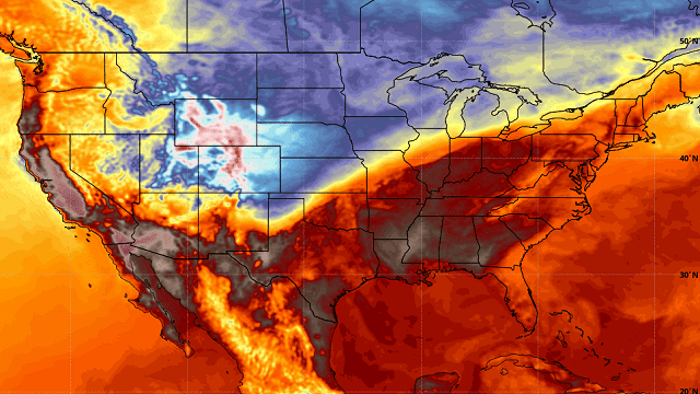
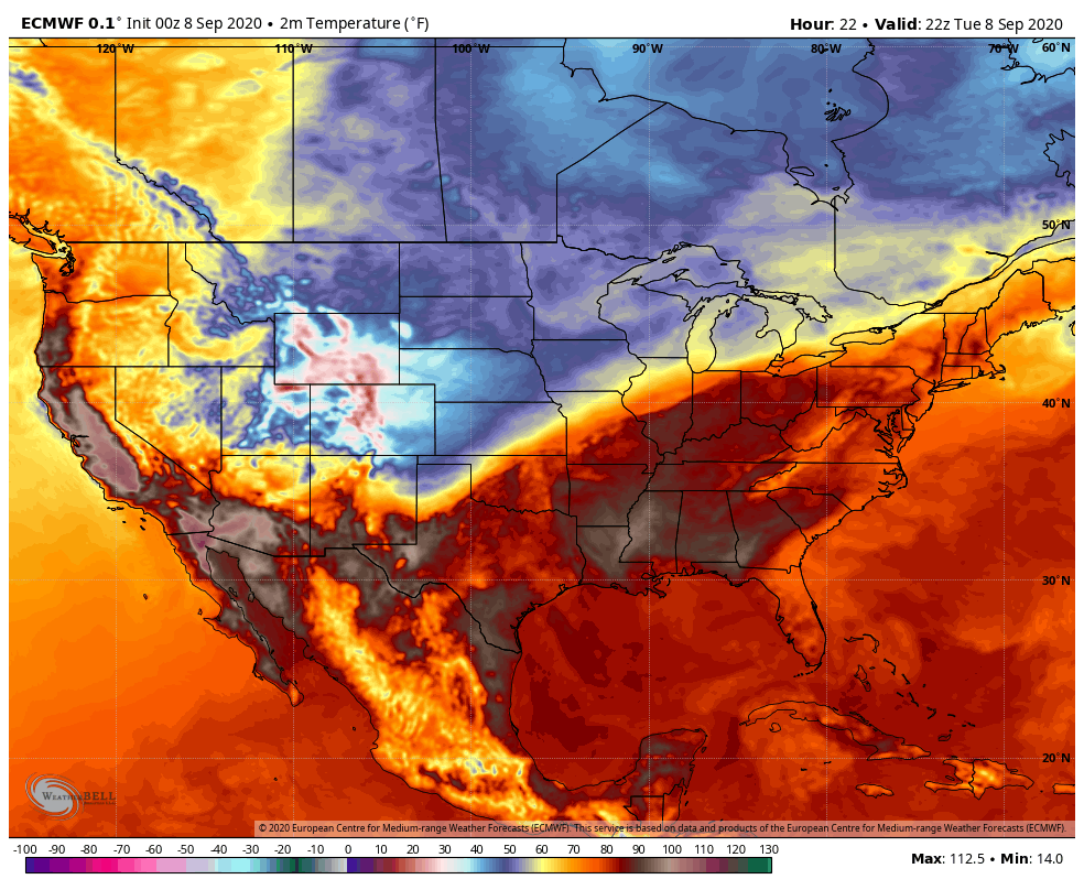
SEPTEMBER SNOW: Winter storm warnings are in effect today for parts of Wyoming, Colorado and far northern New Mexico as a major early-season winter storm unfolds. Snow amounts will exceed 1 foot across higher terrain. Denver is expecting 3 to 6 inches of snow; most of the accumulating snow there will come tonight. Unfortunately, the cold air won’t make it to Alabama.
TROPICS: We have two tropical storms and a tropical wave to discuss this morning. The wave, Invest 94L, is about 250 miles west-southwest of Bermuda, and is producing disorganized showers and thunderstorms. Some gradual development of this system is possible during the next few days while the low moves slowly westward to west-northwestward toward the North Carolina coast.
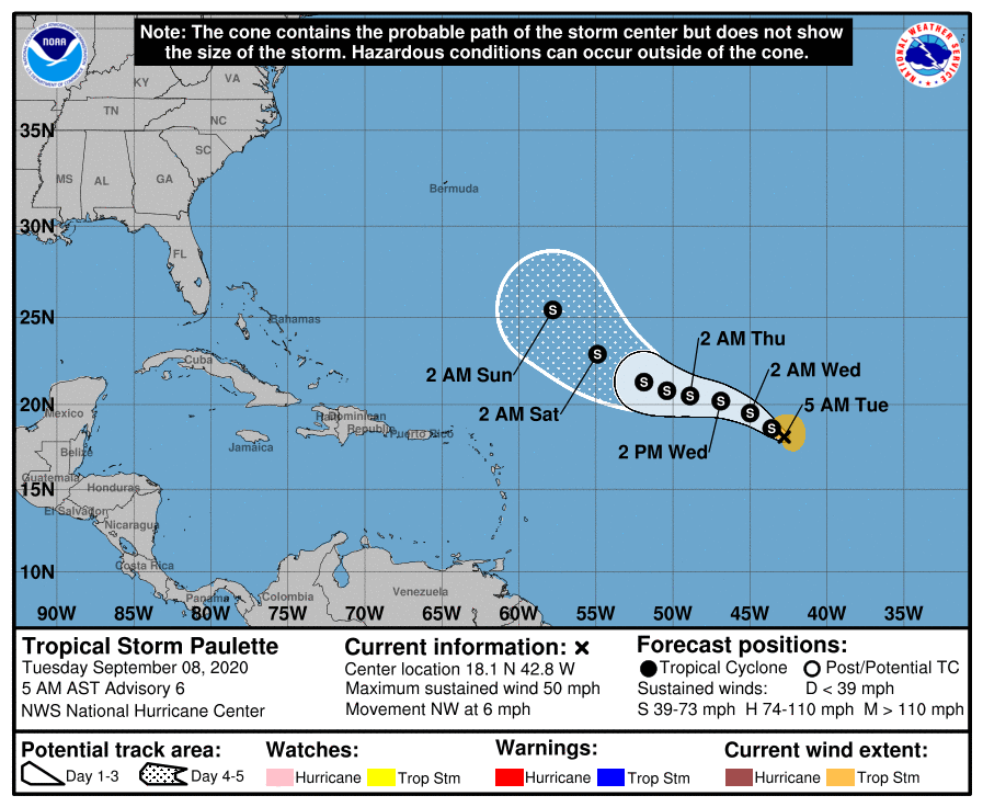
Out in the central and eastern Atlantic, we have tropical storms Paulette and Rene. The lead system, Paulette, is expected to remain below hurricane strength over the next five days; it begins to gain latitude by Friday and the weekend and most likely curves back into the Atlantic without affecting the U.S.
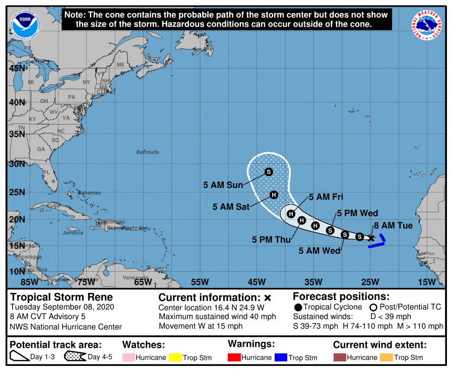
Tropical Storm Rene is expected to briefly become a hurricane in a few days before weakening again this weekend. It will turn sharply north, and will not threaten the U.S. or the Lesser Antilles.
Another tropical wave is forecast to emerge off the west coast of Africa late Wednesday or Thursday. Gradual development is anticipated once the system moves over water, and a tropical depression could form late this week or over the weekend while the system moves generally westward across the eastern tropical Atlantic. It’s too early to know whether this will affect any land mass.
Despite all of this action, the Gulf of Mexico will remain quiet this week.
ON THIS DATE IN 1900: The Great Galveston Hurricane made landfall at Category 4 strength. It remains the deadliest natural disaster in United States history and the fourth-deadliest Atlantic hurricane overall. The hurricane left between 6,000 and 12,000 fatalities in the United States; the number most cited in official reports is 8,000. Most of these deaths occurred in and near Galveston, Texas, after storm surge inundated the coastline with 8 to 12 feet of water. In addition to the number killed, the storm destroyed about 7,000 buildings of all uses in Galveston, which included 3,636 demolished homes; every dwelling in the city suffered some degree of damage. The hurricane left approximately 10,000 people in the city homeless, out of a total population of nearly 38,000. The disaster ended the Golden Era of Galveston, as the hurricane alarmed potential investors, who turned to Houston instead. In response to the storm, three engineers designed and oversaw plans to raise the Gulf of Mexico shoreline of Galveston island by 17 feet and erect a 10-mile seawall.
BEACH FORECAST: Click here to see the AlabamaWx Beach Forecast Center page.
WEATHER BRAINS: You can listen to our weekly 90-minute show anytime on your favorite podcast app. This is the show all about weather featuring many familiar voices, including the meteorologists at ABC 33/40.
CONNECT: You can find me on the major social networks:
Facebook
Twitter
Instagram
Pinterest
Snapchat: spannwx
For more weather news and information from James Spann and his team, visit AlabamaWx.


