James Spann: Scattered showers for Alabama today
James Spann forecasts increasing rain chances for Alabama from Alabama NewsCenter on Vimeo.
AFTERNOON SHOWERS: The radar is quiet across Alabama this morning, but random, scattered showers and thunderstorms will form this afternoon across the state. Odds of any one community seeing rain are 40-50%, and most of the showers will come from about 1 until 10 p.m. There could be a rumble of thunder in spots, but there is no risk of severe storms. The high will be in the mid to upper 80s.
THE ALABAMA WEEKEND: Moisture will deepen Saturday and a few passing showers and thunderstorms are likely. It won’t rain all day, and the best chance of rain will come during the afternoon and evening. With a limited amount of sun, we expect a high in the mid 80s. On Sunday, with a mix of sun and clouds we will have scattered showers and storms during the day, especially by afternoon. The high Sunday afternoon will stay in the mid 80s. The chance of any one spot getting wet is 60-70% Saturday and 40-50% Sunday.
NEXT WEEK: Scattered showers and storms remain possible Monday and Tuesday; the weather trends drier Wednesday through Friday. Highs through the week will be in the 80s, with lows in the upper 60s.
TROPICS: This morning we have two tropical storms and two or three tropical waves to discuss across the Atlantic basin.
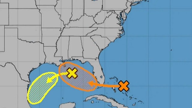
A trough of low pressure is over the north-central Gulf of Mexico this morning. Although the associated shower and thunderstorm activity has diminished since last night, some slow development of this system is possible while it moves westward and then southwestward over the northern and western Gulf of Mexico through early next week. This won’t have much impact on Alabama or the central Gulf Coast as it moves away from the region. The National Hurricane Center is giving this one only a 20% chance of development.
A large area of disorganized showers and thunderstorms extending from near the central and northwest Bahamas eastward over the western Atlantic for a few hundred miles is associated with a surface trough of low pressure. This system is forecast to move westward, crossing the Bahamas and Florida today and moving into the eastern Gulf of Mexico over the weekend. Upper-level winds are expected to become conducive for development, and a tropical depression could form while this system moves slowly west-northwestward over the eastern Gulf of Mexico early next week. The NHC is giving it a 50% chance of becoming a depression or storm.
This system, Invest 96L, will likely bring an increase in rain activity to the central Gulf Coast by Sunday and into early next week, and potential for dangerous rip currents. For the area from Gulf Shores to Panama City Beach, no doubt there will be periods of rain with this feature for a few days, but it won’t rain all day and you should see the sun at times if you have a beach trip planned. It’s hard to forecast the amount of rain for any specific point right now since the wave is very disorganized, but we will keep a close eye on it.
A wave in the far eastern Atlantic (95L) has a high chance of becoming a tropical depression or storm over the next five days, but it remains to be seen if it will affect the U.S. or any land mass. It is a long way away; just something to watch for now.
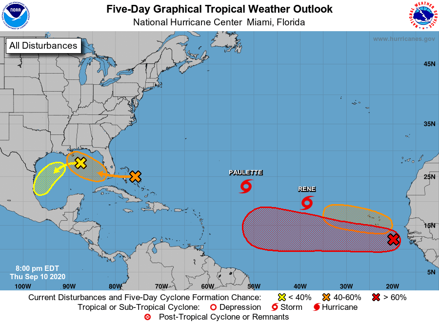
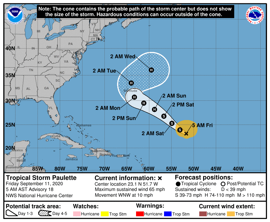
Tropical Storm Paulette has sustained winds of 65 mph this morning and is forecast to be a Category 1 hurricane near Bermuda Monday night. Then it turns east-northeast out to sea and will be no threat to the U.S.
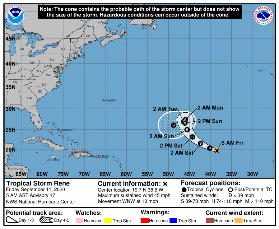
Tropical Storm Rene is forecast to loop around in the Atlantic, far from land, over the next five days.
The next names for tropical storms are Sally, Teddy, Vicky and Wilfred. Then we go to the Greek alphabet.
ON THIS DATE IN 2001: Hurricane Erin was off the coast of New Jersey and New York. A cold front kept Hurricane Erin from drawing closer to the United States, which likely would have affected both weather and air travel in New York and Boston as airlines prepared for a potential strike from a formidable hurricane.
Adverse weather that morning would have been the butterfly effect in action. One small change in the starting conditions could have had a dramatic impact on the end result. A simple, lingering batch of rain or clouds, or even the effects of Hurricane Erin in New York City and Boston on Sept. 11, 2001, could have changed history and the world as we know it.
BEACH FORECAST: Click here to see the AlabamaWx Beach Forecast Center page.
WEATHER BRAINS: You can listen to our weekly 90-minute show anytime on your favorite podcast app. This is the show all about weather featuring many familiar voices, including the meteorologists at ABC 33/40.
CONNECT: You can find me on the major social networks:
Facebook
Twitter
Instagram
Pinterest
Snapchat: spannwx
For more weather news and information from James Spann and his team, visit AlabamaWx.


