James Spann: Sally is inland; rain spreading northward through Alabama
James Spann has the forecast as Hurricane Sally moves through Alabama from Alabama NewsCenter on Vimeo.
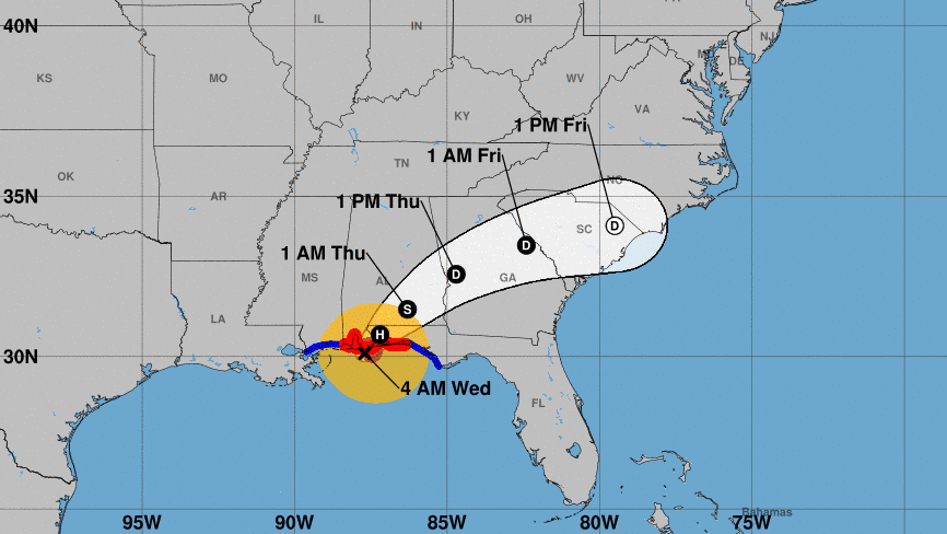
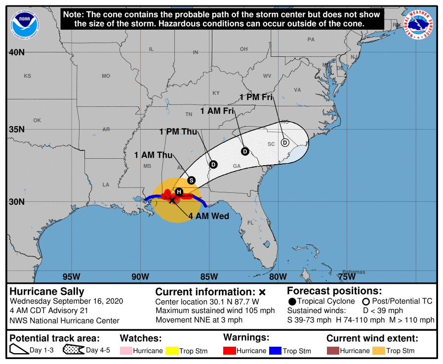
ROUGH NIGHT: It has been a horrible night along the Alabama Gulf Coast, with hurricane-force wind and excessive rain. Hurricane Sally officially made landfall this morning at 4:45 a.m. at Gulf Shores; the eye is moving through southern Baldwin County early this morning and will turn northeast through south Alabama later today as it begins to pick up forward speed.
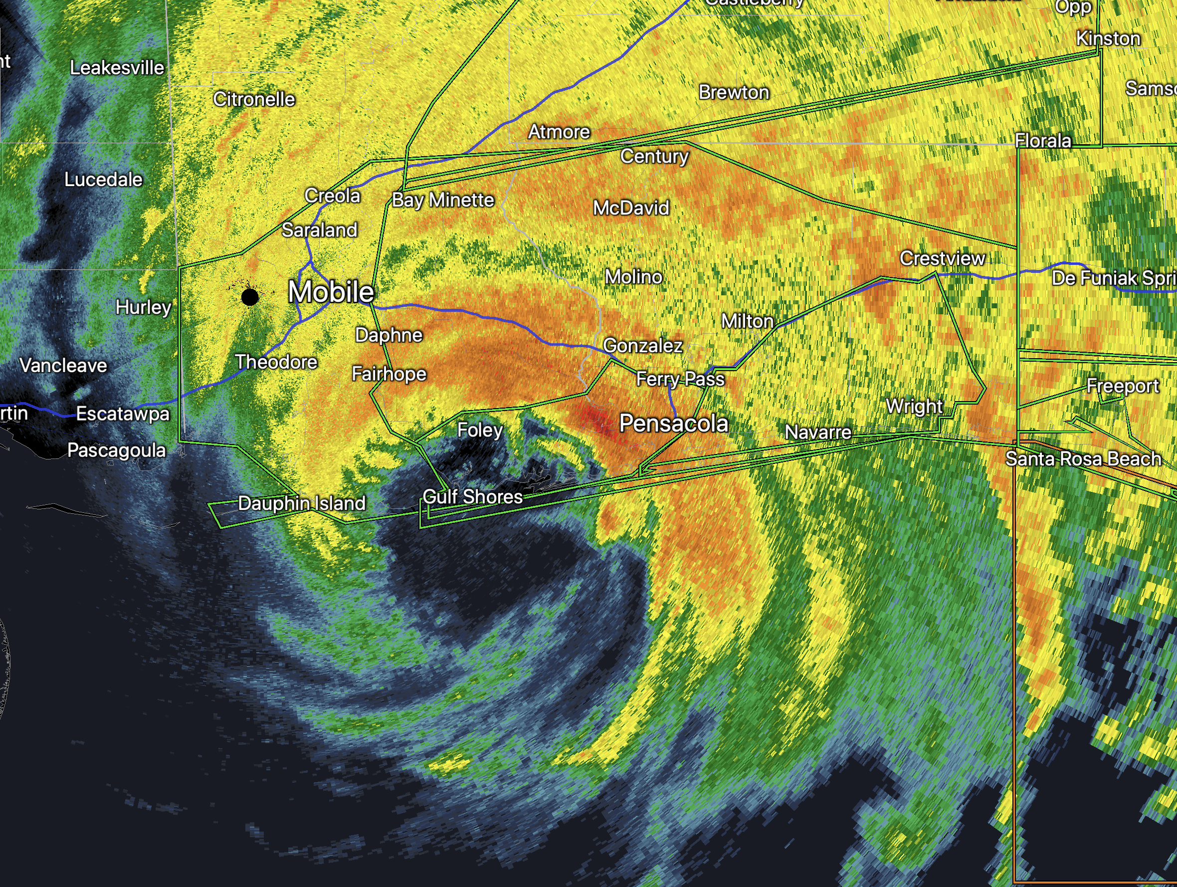
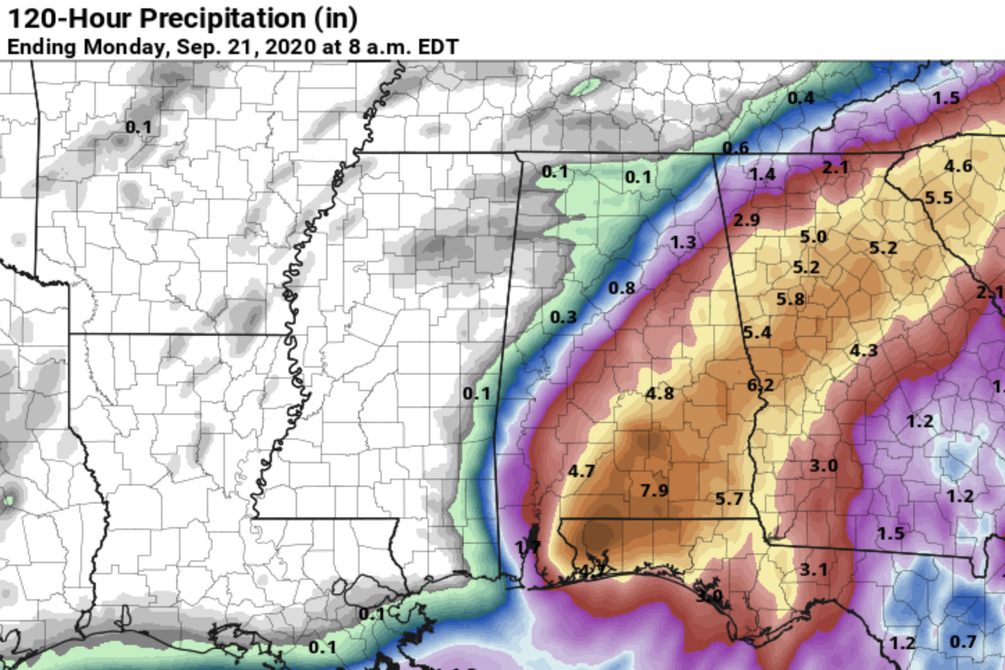
Rain amounts of 10-20 inches are common along the Gulf Coast; officials will be assessing the damage from wind and flooding over the next few hours. Weather conditions will slowly improve along the coast later today as Sally weakens and moves away.
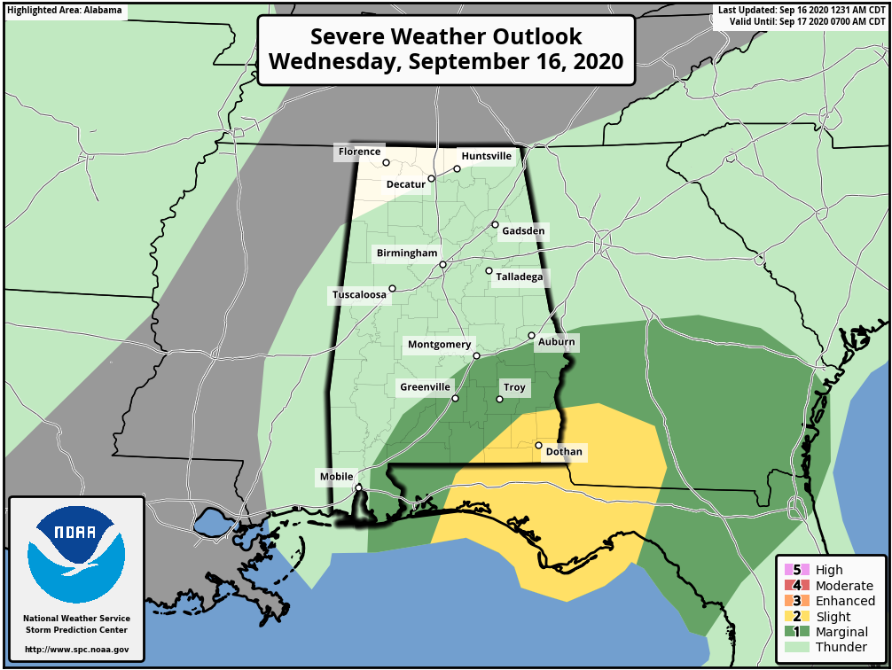
RAIN: A Flash Flood Watch is in effect today for areas along and south of I-59 (Tuscaloosa to Birmingham to Gadsden). The heaviest rain will likely come over the southern and eastern counties, especially east of I-65 and south of I-20. Rain totals from 5-10 inches are likely across southeast Alabama, with amounts of 3-6 inches for parts of east-central Alabama. There will be a very sharp cutoff on the northern fringe of the rain shield; that cutoff will be very close to Tuscaloosa, Birmingham and Gadsden. These cities could see a quarter inch or less, or 1-3 inches — a very close call. Little rain is expected for the northern third of the state.
WIND: Sustained winds over southeast Alabama today will be 20-40 mph as Sally moves through. For the northern half of the state, winds of 15-25 mph are likely. There could be a few isolated power outages over inland parts of south Alabama with some scattered tree and power line damage. We don’t expect any issues with the wind over the north/central part of Alabama.
TORNADOES: A few isolated, brief tornadoes are possible today over southeast Alabama. Higher probabilities are near the southeast corner of the state.
Rain will taper off tonight as Sally begins to gain forward speed and move into Georgia.
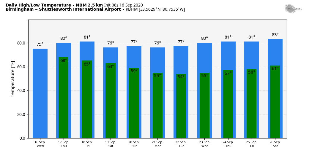
THURSDAY THROUGH THE WEEKEND: Clouds will linger across much of Alabama Thursday; any lingering rain will end during the morning. The high Thursday afternoon will be in the upper 70s for most communities. Then, on Friday, the sky will be partly sunny with a high in the low 80s. Any showers Friday will be over south Alabama, and they will be widely scattered.
The weekend looks very pleasant. There has been some “model madness” concerning potential for moisture return over the southern half of the state; for now we will go with the reliable European global model and forecast a mostly dry weekend, with only a few scattered showers for the far southern counties. Highs will be in the upper 70s and many communities across north Alabama will drop into the upper 50s early Sunday morning. It will feel like fall.
NEXT WEEK: The weather for now looks very quiet, with mostly sunny, pleasant days and fair, cool nights. Highs will be between 78 and 82, lows mostly in the 50s.
TROPICS: Hurricane Paulette is moving into the North Atlantic and will become post-tropical soon. Vicky is a weak, short-lived tropical storm in the eastern Atlantic. Teddy is expected to be a major hurricane tonight and could approach Bermuda (although weakening) by early next week; from there it turns back into the Atlantic and is no threat to the U.S. Invest 98L in the eastern Atlantic should become Tropical Storm Wilfred soon, but it will gain latitude in a few days and is not expected to affect the U.S.
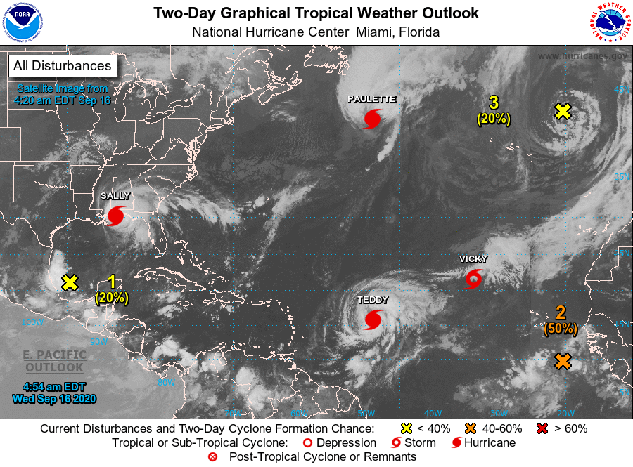
The bottom line is that, after Sally, we see no tropical trouble for the U.S. for the next seven to 10 days.
ON THIS DATE IN 2004: At 51 minutes after midnight, the northern eyewall of Hurricane Ivan moved onto land near Gulf Shores as an upper Category 3 hurricane. The official time of landfall was 2:02 a.m. With 130 mph surface winds and a storm surge of 10-15 feet, the magnitude and extent of the damage and destruction along the Alabama coast exceeded that of both Hurricane Frederic (September 1979) and Hurricane Opal (October 1995). Additionally, Hurricane Ivan was very close to the magnitude of damage and destruction caused by the Hurricane of 1926, which ravaged the aforementioned counties east of Mobile Bay.
Ivan caused widespread tree and power line damage statewide along with widespread power outages. There was also considerable flooding.
BEACH FORECAST: Click here to see the AlabamaWx Beach Forecast Center page.
WEATHER BRAINS: You can listen to our weekly 90-minute show anytime on your favorite podcast app. This is the show all about weather featuring many familiar voices, including the meteorologists at ABC 33/40.
CONNECT: You can find me on the major social networks:
Facebook
Twitter
Instagram
Pinterest
Snapchat: spannwx
For more weather news and information from James Spann and his team, visit AlabamaWx.