James Spann: Quiet weather pattern for Alabama over the weekend

MILD NOVEMBER DAY: Temperatures are mostly in the mid 70s across Alabama, but a few spots on the western side of the state have managed to touch 80 degrees. The average high for Birmingham on Nov. 6 is 69. Tonight will be mostly fair with a low between 55 and 60 degrees.
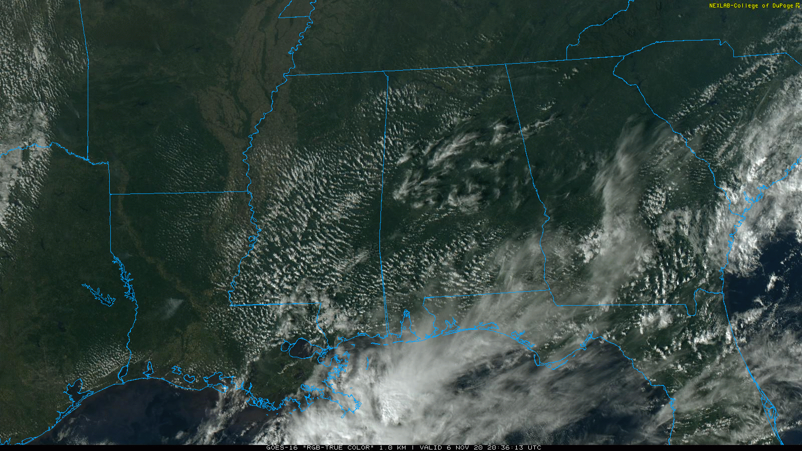
Not much will change over the weekend. Look for partly sunny, mild days and fair nights. A few isolated showers are possible Saturday over the southern half of the state, but most places will stay dry. Highs will be in the mid to upper 70s for most communities.
NEXT WEEK: Monday and Tuesday will be mostly dry, but there will some risk of showers over the latter half of the week. The amount and coverage of rain will depend to some degree on how Tropical Storm Eta behaves in the Gulf of Mexico; for the moment it looks like the most widespread rain associated with the system will be south and east of Alabama.
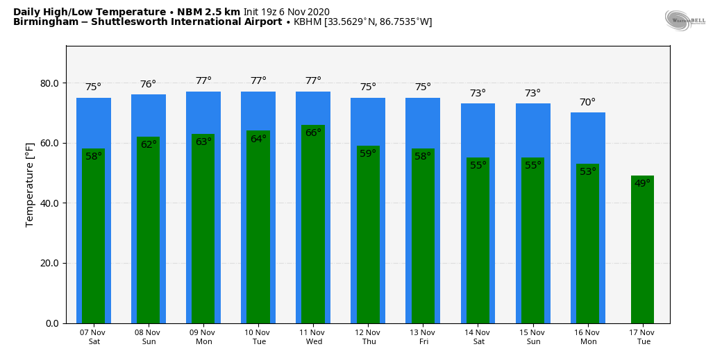
There’s no sign of freezing temperatures for Alabama over the next 10 days, and the latest Climate Prediction Center outlook for Nov. 14-20 suggests temperatures will be above average here and over the eastern half of the nation.
TROPICS: Eta is a tropical depression in the western Caribbean; it is expected to reach tropical storm strength again tonight as it moves to the northeast. The latest forecast track from the National Hurricane Center puts the system over Cuba late Saturday night, near the Florida Keys Monday and into the southeast Gulf of Mexico Monday night.
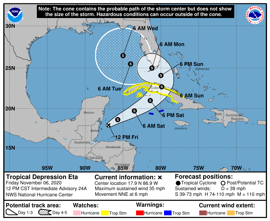
We are getting better model agreement this afternoon; most suggest Eta will begin to turn northeast again, moving over north Florida by the middle of next week, which would keep Alabama on the drier west side of the system. But it remains to be seen exactly what, if any, impact Eta will have on Alabama or the central Gulf Coast. We will have better clarity over the weekend as the system becomes better organized and we get upper-air data from hurricane hunters.
The rest of the Atlantic basin is quiet; hurricane season ends Nov. 30.
ON THIS DATE IN 1977: The Kelly Barnes Dam above the Toccoa Falls Bible College near Toccoa, Georgia, failed in the early morning. Thirty-nine people died in the resulting flood, which inundated part of the campus, including a trailer park.
ON THIS DATE IN 2005: The deadliest tornado to strike Indiana since April 3, 1974, occurred around 2 a.m. A single EF3 tornado inflicted 24 fatalities, 238 injuries and nearly $90 million in damage with a path length of 41 miles. This storm moved in a northeasterly direction from just north of Smith Mills, Kentucky, to Gentryville, Indiana, and crossed the Ohio River three times. Most of the damage occurred as the tornado passed southeast of Evansville, Indiana.
BEACH FORECAST: Click here to see the AlabamaWx Beach Forecast Center page.
WEATHER BRAINS: You can listen to our weekly 90-minute show anytime on your favorite podcast app. This is the show all about weather featuring many familiar voices, including the meteorologists at ABC 33/40.
CONNECT: You can find me on the major social networks:
Facebook
Twitter
Instagram
Pinterest
Snapchat: spannwx
For more weather news and information from James Spann and his team, visit AlabamaWx.


