James Spann: Light rain for Alabama tonight, big soaking Sunday
James Spann has the Alabama forecast for Black Friday and beyond from Alabama NewsCenter on Vimeo.
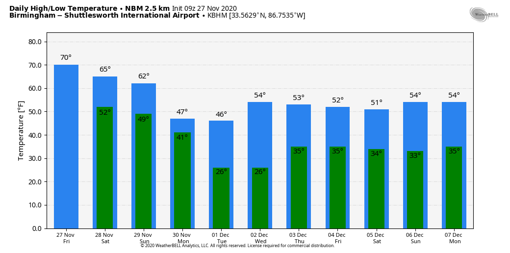
ACTIVE PATTERN CONTINUES: A wave of low pressure will move along a stalled surface front over south Alabama today; we note a few showers from near Montgomery to Opelika early this morning just north of the front. The wave will bring rain to about the southern two-thirds of the state later today and tonight. The most widespread rain comes south of U.S. 80 (Demopolis to Selma to Montgomery to Opelika); north of there, rain will be fairly light and spotty. Otherwise, clouds will increase today with a high around 70 degrees.
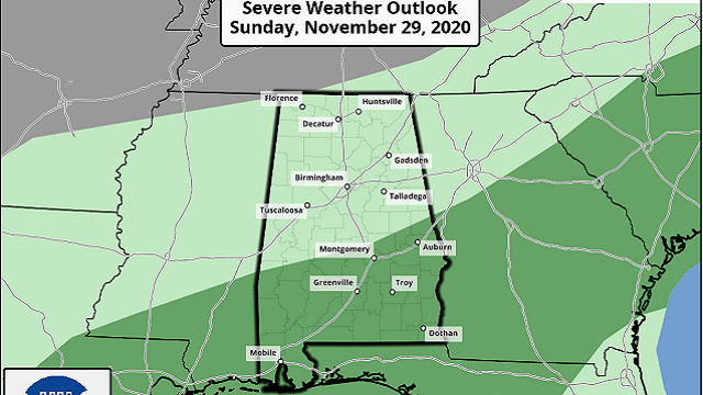
THE ALABAMA WEEKEND: Saturday will be dry for most of the state; with a mostly sunny sky the high will be in the mid 60s. Any showers will be confined to far south Alabama, and even there they will be widely scattered. Clouds return Sunday as yet another wave forms on the front, and a statewide soaking is likely Sunday afternoon and Sunday night as the surface low moves through north Alabama. Rain amounts of 1-2 inches are likely, and a few strong storms are possible over the southern half of the state, where the Storm Prediction Center has defined a marginal risk (level 1 out of 5) of severe thunderstorms.
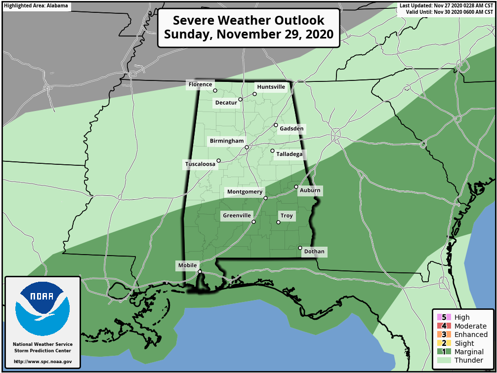
A few storms across south Alabama late Sunday and Sunday night could produce small hail and strong, gusty winds. A brief, isolated tornado can’t be totally ruled out.
NEXT WEEK: The rain ends very early Monday, followed by the arrival of the coldest air so far this season. Monday will be windy and cold, with temperatures slipping into the 30s over the northern third of the state by afternoon. A few flurries are possible over far north Alabama as the cold air rushes in, but there won’t be any accumulation or impact; the cold air is the big story.
Temperatures drop into the 20- to 26-degree range by early Tuesday morning over north and central Alabama, with a freeze all the way down to the Gulf Coast. Wednesday morning could be just as cold; then we moderate slowly for the rest of the week. A disturbance will bring some clouds to the state toward the end of the week, but for the moment the air looks too dry for any really significant rain.
IRON BOWL: We are expecting picture-perfect weather for Saturday’s Iron Bowl in Tuscaloosa (Auburn at Alabama; 2:30 p.m. kickoff). The sky will be mostly sunny with temperatures falling from near 65 at kickoff to 60 at the final whistle.
HIGH SCHOOL PLAYOFFS: Some rain is possible for the high school football playoff games across the state tonight, with the most widespread rain over the southern half of the state. Temperatures will be in the 50s.
ON THIS DATE IN 1898: A powerful storm known as the “Portland Gale” affected the coastal areas of New England on Nov. 26-27. The storm formed when two areas of low pressure merged off the coast of New Jersey and traveled up the East Coast. This storm produced hurricane-force winds in Nantucket and sank more than 150 boats and ships.
ON THIS DATE IN 2019: Three EF-0 tornadoes touched down in Pike and Barbour counties in south Alabama.
BEACH FORECAST: Click here to see the AlabamaWx Beach Forecast Center page.
WEATHER BRAINS: You can listen to our weekly 90-minute show any time on your favorite podcast app. This is the show all about weather featuring many familiar voices, including the meteorologists at ABC 33/40.
CONNECT: You can find me on the major social networks:
For more weather news and information from James Spann and his team, visit AlabamaWx.


